Hamilton County, Nebraska
| Hamilton County, Nebraska | |
|---|---|
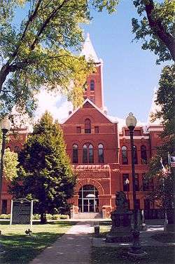 Hamilton County courthouse in Aurora | |
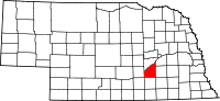 Location in the U.S. state of Nebraska | |
 Nebraska's location in the U.S. | |
| Founded | 1870 |
| Named for | Alexander Hamilton |
| Seat | Aurora |
| Largest city | Aurora |
| Area | |
| • Total | 547 sq mi (1,417 km2) |
| • Land | 544 sq mi (1,409 km2) |
| • Water | 4.1 sq mi (11 km2), 0.8% |
| Population | |
| • (2010) | 9,124 |
| • Density | 17/sq mi (7/km²) |
| Congressional district | 3rd |
| Time zone | Central: UTC-6/-5 |
| Website |
www |
Hamilton County is a county located in the U.S. state Nebraska. As of the 2010 census, the population was 9,124.[1] Its county seat is Aurora.[2] The county was named for Alexander Hamilton, the first Secretary of the Treasury.
Hamilton County is included in the Grand Island, NE Metropolitan Statistical Area.
In the Nebraska license plate system, Hamilton County is represented by the prefix 28 (it had the twenty-eighth-largest number of vehicles registered in the county when the license plate system was established in 1922).
History
The first permanent settlers arrived in Hamilton County in 1866.[3] Hamilton County was created in 1867[4] and later organized in 1870.[5][6] It was named after Alexander Hamilton.[7]
Geography
According to the U.S. Census Bureau, the county has a total area of 547 square miles (1,420 km2), of which 543 square miles (1,410 km2) is land and 4.1 square miles (11 km2) (0.8%) is water.[8]
Major highways
Adjacent counties
- Polk County (northeast)
- York County (east)
- Clay County (south)
- Hall County (west)
- Merrick County (north)
Demographics
| Historical population | |||
|---|---|---|---|
| Census | Pop. | %± | |
| 1870 | 130 | — | |
| 1880 | 8,267 | 6,259.2% | |
| 1890 | 14,096 | 70.5% | |
| 1900 | 13,330 | −5.4% | |
| 1910 | 13,459 | 1.0% | |
| 1920 | 13,237 | −1.6% | |
| 1930 | 12,159 | −8.1% | |
| 1940 | 9,982 | −17.9% | |
| 1950 | 8,778 | −12.1% | |
| 1960 | 8,714 | −0.7% | |
| 1970 | 8,867 | 1.8% | |
| 1980 | 9,301 | 4.9% | |
| 1990 | 8,862 | −4.7% | |
| 2000 | 9,403 | 6.1% | |
| 2010 | 9,124 | −3.0% | |
| Est. 2015 | 9,190 | [9] | 0.7% |
| U.S. Decennial Census[10] 1790-1960[11] 1900-1990[12] 1990-2000[13] 2010-2013[1] | |||
As of the census[14] of 2000, there were 9,403 people, 3,503 households, and 2,676 families residing in the county. The population density was 17 people per square mile (7/km²). There were 3,850 housing units at an average density of 7 per square mile (3/km²). The racial makeup of the county was 98.43% White, 0.18% Black or African American, 0.12% Native American, 0.22% Asian, 0.49% from other races, and 0.56% from two or more races. 1.14% of the population were Hispanic or Latino of any race.
There were 3,503 households out of which 37.30% had children under the age of 18 living with them, 67.40% were married couples living together, 5.90% had a female householder with no husband present, and 23.60% were non-families. 21.10% of all households were made up of individuals and 10.10% had someone living alone who was 65 years of age or older. The average household size was 2.64 and the average family size was 3.07.
In the county the population was spread out with 29.10% under the age of 18, 5.90% from 18 to 24, 26.50% from 25 to 44, 23.20% from 45 to 64, and 15.30% who were 65 years of age or older. The median age was 38 years. For every 100 females there were 99.40 males. For every 100 females age 18 and over, there were 96.10 males.
The median income for a household in the county was $40,277, and the median income for a family was $45,659. Males had a median income of $29,238 versus $20,308 for females. The per capita income for the county was $17,590. About 5.90% of families and 7.50% of the population were below the poverty line, including 9.80% of those under age 18 and 5.40% of those age 65 or over.
Communities
See also
References
- 1 2 "State & County QuickFacts". United States Census Bureau. Retrieved September 20, 2013.
- ↑ "Find a County". National Association of Counties. Retrieved 2011-06-07.
- ↑ Burr, George L. (1921). History of Hamilton and Clay Counties, Nebraska, Volume 1. S.J. Clarke Publishing Company. p. 116.
- ↑ Fitzpatrick, Lilian Linder (1925). Nebraska Place-Names. Lincoln: University of Nebraska Studies in Language, Literature, and Criticism. p. 70. Retrieved December 15, 2014.
- ↑ "Hamilton County Nebraska Historic Buildings Survey" (PDF). Nebraska State Historical Society. July 2009. Retrieved December 15, 2014.
- ↑ Andreas, A. T. (1882). "Andreas' History of the State of Nebraska". The Kansas Collection. Retrieved December 15, 2014.
- ↑ Retrieved on March 15, 2008.
- ↑ "2010 Census Gazetteer Files". United States Census Bureau. August 22, 2012. Retrieved December 8, 2014.
- ↑ "County Totals Dataset: Population, Population Change and Estimated Components of Population Change: April 1, 2010 to July 1, 2015". Retrieved July 2, 2016.
- ↑ "U.S. Decennial Census". United States Census Bureau. Retrieved December 8, 2014.
- ↑ "Historical Census Browser". University of Virginia Library. Retrieved December 8, 2014.
- ↑ "Population of Counties by Decennial Census: 1900 to 1990". United States Census Bureau. Retrieved December 8, 2014.
- ↑ "Census 2000 PHC-T-4. Ranking Tables for Counties: 1990 and 2000" (PDF). United States Census Bureau. Retrieved December 8, 2014.
- ↑ "American FactFinder". United States Census Bureau. Retrieved 2008-01-31.
External links
 |
Merrick County | Polk County | | |
| Hall County | |
York County | ||
| ||||
| | ||||
| Clay County |
Municipalities and communities of Hamilton County, Nebraska, United States | ||
|---|---|---|
| City | ||
| Villages | ||
| CDPs | ||
Coordinates: 40°53′N 98°01′W / 40.88°N 98.02°W