Harrison Township, Benton County, Iowa
| Harrison Township | |
|---|---|
| Township | |
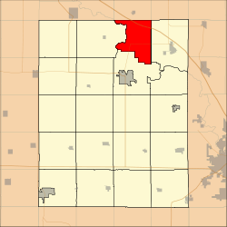 Location in Benton County | |
| Coordinates: 42°15′12″N 91°59′19″W / 42.25333°N 91.98861°WCoordinates: 42°15′12″N 91°59′19″W / 42.25333°N 91.98861°W | |
| Country |
|
| State |
|
| County | Benton |
| Area | |
| • Total | 27.05 sq mi (70.07 km2) |
| • Land | 26.57 sq mi (68.81 km2) |
| • Water | 0.48 sq mi (1.25 km2) 1.78% |
| Elevation | 810 ft (247 m) |
| Population (2000) | |
| • Total | 354 |
| • Density | 13.3/sq mi (5.1/km2) |
| Time zone | CST (UTC-6) |
| • Summer (DST) | CDT (UTC-5) |
| ZIP code | 52349 |
| GNIS feature ID | 0468010 |
Harrison Township is one of twenty townships in Benton County, Iowa, USA. As of the 2000 census, its population was 354.[1]
History
Harrison Township was founded in 1849.[2]
Geography
According to the United States Census Bureau, Harrison Township covers an area of 27.05 square miles (70.07 square kilometers); of this, 26.57 square miles (68.81 square kilometers, 98.2 percent) is land and 0.48 square miles (1.25 square kilometers, 1.78 percent) is water.
Adjacent townships
- Jefferson Township, Buchanan County (north)
- Homer Township, Buchanan County (northeast)
- Polk Township (east)
- Taylor Township (south)
- Cedar Township (west)
Cemeteries
The township contains Bear Creek Cemetery.
Major highways
Landmarks
- Minne Estema Park
- Mount Auburn Bridge Park
School districts
- Independence Community School District
- Vinton-Shellsburg Community School District
Political districts
- Iowa's 3rd congressional district
- State House District 39
- State Senate District 20
References
- United States Census Bureau 2007 TIGER/Line Shapefiles
- United States Board on Geographic Names (GNIS)
- United States National Atlas
- ↑ United States Census Bureau American FactFinder
- ↑ The History of Benton County, Iowa, Containing a History of the County, Its Cities, Towns, &c. Western Historical. 1878. p. 312.
External links
| Wikimedia Commons has media related to Harrison Township, Benton County, Iowa. |
Municipalities and communities of Benton County, Iowa, United States | ||
|---|---|---|
| Cities | ||
| Townships | ||
| CDP | ||
| Unincorporated communities | ||
| Footnotes | ‡This populated place also has portions in an adjacent county or counties | |
This article is issued from Wikipedia - version of the 10/30/2016. The text is available under the Creative Commons Attribution/Share Alike but additional terms may apply for the media files.