Taylor Township, Benton County, Iowa
| Taylor Township | |
|---|---|
| Township | |
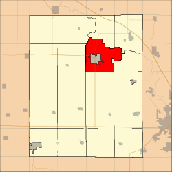 Location in Benton County | |
| Coordinates: 42°10′19″N 92°00′04″W / 42.17194°N 92.00111°WCoordinates: 42°10′19″N 92°00′04″W / 42.17194°N 92.00111°W | |
| Country |
|
| State |
|
| County | Benton |
| Area | |
| • Total | 36.7 sq mi (95.04 km2) |
| • Land | 36.13 sq mi (93.59 km2) |
| • Water | 0.56 sq mi (1.46 km2) 1.54% |
| Elevation | 768 ft (234 m) |
| Population (2000) | |
| • Total | 781 |
| • Density | 21.6/sq mi (8.3/km2) |
| Time zone | CST (UTC-6) |
| • Summer (DST) | CDT (UTC-5) |
| ZIP code | 52349 |
| GNIS feature ID | 0468783 |
Taylor Township is one of twenty townships in Benton County, Iowa, USA. As of the 2000 census, its population was 781.[1]
History
Taylor Township was founded in 1846.[2]
Geography
According to the United States Census Bureau, Taylor Township covers an area of 36.7 square miles (95.04 square kilometers); of this, 36.13 square miles (93.59 square kilometers, 98.47 percent) is land and 0.56 square miles (1.46 square kilometers, 1.54 percent) is water.
The city of Vinton is entirely within this township geographically but is a separate entity.
Adjacent townships
- Harrison Township (north)
- Polk Township (northeast)
- Benton Township (east)
- Canton Township (southeast)
- Eden Township (south)
- Big Grove Township (southwest)
- Jackson Township (west)
- Vinton Township (west)
- Cedar Township (northwest)
Cemeteries
The township contains these five cemeteries: Maplewood, Pettit Hill, Plum Grove, Saint Marys and United Brethren.
Major highways
Airports and landing strips
- Vinton Veterans Memorial Airpark
School districts
- Vinton-Shellsburg Community School District
Political districts
- Iowa's 3rd congressional district
- State House District 39
- State Senate District 20
References
- United States Census Bureau 2007 TIGER/Line Shapefiles
- United States Board on Geographic Names (GNIS)
- United States National Atlas
- ↑ United States Census Bureau American FactFinder
- ↑ The History of Benton County, Iowa, Containing a History of the County, Its Cities, Towns, &c. Western Historical. 1878. p. 312.
External links
| Wikimedia Commons has media related to Taylor Township, Benton County, Iowa. |
Municipalities and communities of Benton County, Iowa, United States | ||
|---|---|---|
| Cities | ||
| Townships | ||
| CDP | ||
| Unincorporated communities | ||
| Footnotes | ‡This populated place also has portions in an adjacent county or counties | |
This article is issued from Wikipedia - version of the 11/1/2016. The text is available under the Creative Commons Attribution/Share Alike but additional terms may apply for the media files.