Kane Township, Benton County, Iowa
| Kane Township | |
|---|---|
| Township | |
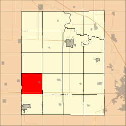 Location in Benton County | |
| Coordinates: 41°59′36″N 92°14′25″W / 41.99333°N 92.24028°WCoordinates: 41°59′36″N 92°14′25″W / 41.99333°N 92.24028°W | |
| Country |
|
| State |
|
| County | Benton |
| Area | |
| • Total | 35.59 sq mi (92.17 km2) |
| • Land | 35.59 sq mi (92.17 km2) |
| • Water | 0 sq mi (0 km2) 0% |
| Elevation | 906 ft (276 m) |
| Population (2000) | |
| • Total | 944 |
| • Density | 26.5/sq mi (10.2/km2) |
| Time zone | CST (UTC-6) |
| • Summer (DST) | CDT (UTC-5) |
| ZIP codes | 52208, 52225, 52249 |
| GNIS feature ID | 0468158 |
Kane Township is one of twenty townships in Benton County, Iowa, USA. As of the 2000 census, its population was 944.[1]
Geography
According to the United States Census Bureau, Kane Township covers an area of 35.59 square miles (92.17 square kilometers).
Cities, towns, villages
Adjacent townships
- Homer Township (north)
- Big Grove Township (northeast)
- Union Township (east)
- Leroy Township (southeast)
- Iowa Township (south)
- Salt Creek Township, Tama County (southwest)
- York Township, Tama County (west)
- Oneida Township, Tama County (northwest)
Cemeteries
The township contains these four cemeteries: Holy Cross, Irving, Keystone and Redman.
Major highways
School districts
- Belle Plaine Community School District
- Benton Community School District
Political districts
- Iowa's 3rd congressional district
- State House District 39
- State Senate District 20
References
- United States Census Bureau 2007 TIGER/Line Shapefiles
- United States Board on Geographic Names (GNIS)
- United States National Atlas
External links
| Wikimedia Commons has media related to Kane Township, Benton County, Iowa. |
Municipalities and communities of Benton County, Iowa, United States | ||
|---|---|---|
| Cities | ||
| Townships | ||
| CDP | ||
| Unincorporated communities | ||
| Footnotes | ‡This populated place also has portions in an adjacent county or counties | |
This article is issued from Wikipedia - version of the 11/17/2013. The text is available under the Creative Commons Attribution/Share Alike but additional terms may apply for the media files.