Aure, Norway
| Aure kommune | |||
|---|---|---|---|
| Municipality | |||
 | |||
| |||
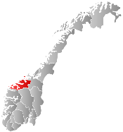
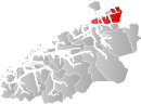 Aure within Møre og Romsdal | |||
| Coordinates: 63°16′7″N 8°36′28″E / 63.26861°N 8.60778°ECoordinates: 63°16′7″N 8°36′28″E / 63.26861°N 8.60778°E | |||
| Country | Norway | ||
| County | Møre og Romsdal | ||
| District | Nordmøre | ||
| Administrative centre | Aure | ||
| Government | |||
| • Mayor (2007) | Ingunn Oldervik Golmen (Sp) | ||
| Area | |||
| • Total | 643.94 km2 (248.63 sq mi) | ||
| • Land | 624.25 km2 (241.02 sq mi) | ||
| • Water | 19.69 km2 (7.60 sq mi) | ||
| Population (2010) | |||
| • Total | 3,570 | ||
| • Density | 5.7/km2 (15/sq mi) | ||
| • Change (10 years) | 33.7 % | ||
| Demonym(s) | Aurgjelding[1] | ||
| Time zone | CET (UTC+1) | ||
| • Summer (DST) | CEST (UTC+2) | ||
| ISO 3166 code | NO-1576 | ||
| Official language form | Neutral | ||
| Website |
www | ||
|
| |||
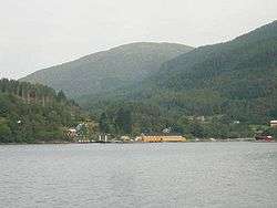
Aure is a municipality in Møre og Romsdal county, Norway. It is part of the region of Nordmøre. The administrative centre is the village of Aure. Other villages in Aure include Gullstein, Stemshaug, Todalen, Tjeldbergodden, and Tømmervåg. Aure has one of the largest wooden churches in Norway, Aure Church.
General information
The municipality was established on 1 January 1838 (see formannskapsdistrikt). On 1 January 1894, the southern district of Aure (population: 942) was separated to form the new municipality of Valsøyfjord. Then on 1 July 1914, the northeastern district of Aure (population: 851) was separated to form the new municipality of Stemshaug. On 1 January 1965, the municipality of Stemshaug (population: 877), the part of Valsøyfjord municipality on the island of Ertvågsøya (population: 141), and the part of Tustna municipality on Ertvågsøya (population: 85) were all merged into the municipality of Aure. On 1 January 1976, the district of Aure located south of the Vinjefjorden (population: 158) was merged into Halsa Municipality. On 1 January 2006, the municipality of Tustna was merged into Aure.[2]
Name
The municipality (originally the parish) is named after the old Aure farm (Old Norse: Aurar), since the first church (Aure Church) was built there. The name is the plural form of aurr which means "gravel".[3]
Coat-of-arms
The coat-of-arms were granted in 2006 when the municipalities of Tustna and Aure were merged. They are based on the arms of the old municipality of Tustna, only the colors were changed. The arms show a white klippfisk (cod) on a blue background. The commercial production of cod in Norway started in Tustna around 1690.[4]
-

Current arms of Aure (since 2006)
-
Old arms of Aure (before 2006)
-

Old arms of Tustna (before 2006)
Churches
The Church of Norway has three parishes (sokn) within the municipality of Aure. It is part of the Ytre Nordmøre deanery in the Diocese of Møre.
| Parish (Sokn) | Church Name | Location of the Church | Year Built |
|---|---|---|---|
| Aure | Aure Church | Aure | 1924 |
| Stemshaug | Stemshaug Church | Stemshaug | 1908 |
| Tustna | Gullstein Church | Gullstein | 1864 |
| Sør-Tustna Chapel | Tømmervåg | 1952 |
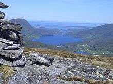
Geography
.jpg)
The municipality includes many islands as well as some parts of the mainland. Islands of Aure include Ertvågsøya, Grisvågøya, Rottøya, Ruøya, Skardsøya, Solskjelsøya, Stabblandet, and Tustna. The Vinjefjorden, Arasvikfjord, and Edøyfjorden surround the municipality. Several bridges connect the islands including the Mjosund Bridge, Aursund Bridge, and Dromnessund Bridge.
Economy
Agriculture and aquaculture employ 13.6% of the workforce, mostly within dairy farming, fishing, and fish farming. Manufacturing industry and construction employ 25.5%, where the most important industries are the shipyards in Mjosundet and the natural gas processing plant in Tjeldbergodden, as well as the Tjeldbergodden Reserve Power Station. A liquefied natural gas (LNG) pipeline from the Heidrun oil field terminates here. The remaining 60.5% work in the service industry.[5]
Notable residents
- Kristofer Leirdal, famous sculptor is originally from Aure
- Anne Marie Stavnes (1918-2002), politician
References
- ↑ "Navn på steder og personer: Innbyggjarnamn" (in Norwegian). Språkrådet. Retrieved 2015-12-01.
- ↑ Jukvam, Dag (1999). "Historisk oversikt over endringer i kommune- og fylkesinndelingen" (PDF) (in Norwegian). Statistisk sentralbyrå.
- ↑ Rygh, Oluf (1908). Norske gaardnavne: Romsdals amt (in Norwegian) (13 ed.). Kristiania, Norge: W. C. Fabritius & sønners bogtrikkeri. p. 433.
- ↑ "Kommunevåpen". Aure Kommune. Archived from the original on 2016-03-03. Retrieved 2008-10-18.
- ↑ "Tall om Aure kommune 2008". Archived from the original on 2007-10-14. Retrieved 2010-02-25.