Hinje, Žužemberk
| Hinje | |
|---|---|
| Village | |
 | |
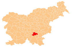
 Hinje Location in Slovenia | |
| Coordinates: 45°45′58.56″N 14°53′10.34″E / 45.7662667°N 14.8862056°ECoordinates: 45°45′58.56″N 14°53′10.34″E / 45.7662667°N 14.8862056°E | |
| Country |
|
| Traditional region | Lower Carniola |
| Statistical region | Southeast Slovenia |
| Municipality | Žužemberk |
| Area | |
| • Total | 4.71 km2 (1.82 sq mi) |
| Elevation | 518.6 m (1,701.4 ft) |
| Population (2012) | |
| • Total | 70 |
| • Density | 15/km2 (40/sq mi) |
| [1] | |
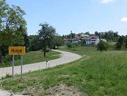
Hinje (pronounced [ˈxiːnjɛ]; German: Hinnach[2]) is a small village in the Municipality of Žužemberk in southeastern Slovenia. The area is part of the historical region of Lower Carniola. The municipality is now included in the Southeast Slovenia Statistical Region.[3]
Name
Hinje was attested in written sources in 1372 as Bechyn (and as Hynoch in 1382 and Pchin in 1422). The name is derived from *Bhinje or *Bihinje, likely derived from the plural demonym *Byxyn′ane based on the hydronym *Byxyn′a (which yielded the name of Hinja Creek near Hinje in the Municipality of Sevnica). The first unaccented syllable was lost through modern vowel reduction. The name therefore means 'people living along Hinja Creek' and may refer to settlers from the Hinja Creek area that moved to Hinje in the Municipality of Žužemberk.[4] The village was known as Hinnach in German in the past.[2]
Parish church
The local parish church is dedicated to the Annunciation of the Blessed Virgin Mary and belongs to the Roman Catholic Diocese of Novo Mesto. The church, originally erected around 1800,[5] was burned in January 1945, during World War II, by the Slovene Partisans, and rebuilt only in 1971. It was reconsecrated in 1972.[6]
Gallery
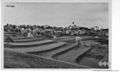 Postcard of Hinje before World War II
References
- ↑ "Hinje, Žužemberk". Place Names. Statistical Office of the Republic of Slovenia. Retrieved 21 March 2013.
- 1 2 Leksikon občin kraljestev in dežel zastopanih v državnem zboru, vol. 6: Kranjsko. 1906. Vienna: C. Kr. Dvorna in Državna Tiskarna, p. 174.
- ↑ Žužemberk municipal site
- ↑ Snoj, Marko. 2009. Etimološki slovar slovenskih zemljepisnih imen. Ljubljana: Modrijan and Založba ZRC, p. 159.
- ↑ Stele, France. "Hinje, ž.c.". Steletovi zapiski [Stele's Notes] (in Slovenian). Scientific Research Centre of the Slovene Academy of Sciences and Arts. Retrieved 21 March 2013.
- ↑ Škufca, Nataša (2009). Geografija Krajevne skupnosti Hinje: primerjava vasi Lazina in Visejec [The Geography of the Local Community of Hinje: The Comparison of the Villages of Lazina and Visejec] (PDF) (in Slovenian). Department of Geography, University of Ljubljana. pp. 16–17.
External links
 Media related to Hinje, Žužemberk at Wikimedia Commons
- Hinje at Geopedia
![Steletovi zapiski [Stele's Notes]](http://arzenal.zrc-sazu.si/static/tmp/1617743e5353208e13ac09dd3826b647.jpg)