Howard Township, Parke County, Indiana
| Howard Township | |
|---|---|
| Township | |
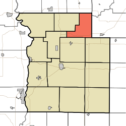 Location in Parke County | |
| Coordinates: 39°54′11″N 87°07′58″W / 39.90306°N 87.13278°WCoordinates: 39°54′11″N 87°07′58″W / 39.90306°N 87.13278°W | |
| Country |
|
| State |
|
| County | Parke |
| Government | |
| • Type | Indiana township |
| Area | |
| • Total | 23.82 sq mi (61.7 km2) |
| • Land | 23.75 sq mi (61.5 km2) |
| • Water | 0.07 sq mi (0.2 km2) 0.29% |
| Elevation | 751 ft (229 m) |
| Population (2010) | |
| • Total | 341 |
| • Density | 14.4/sq mi (5.6/km2) |
| ZIP codes | 47859, 47872, 47989 |
| GNIS feature ID | 0453420 |
Howard Township is one of thirteen townships in Parke County, Indiana, United States. As of the 2010 census, its population was 341 and it contained 157 housing units.[1] The township includes the western end of Shades State Park and the southeast quarter of Turkey Run State Park.
History
Howard Township was established about 1855, and named for General Howard, an early settler.[2]
Geography
According to the 2010 census, the township has a total area of 23.82 square miles (61.7 km2), of which 23.75 square miles (61.5 km2) (or 99.71%) is land and 0.07 square miles (0.18 km2) (or 0.29%) is water.[1]
Unincorporated towns
- Banner Mills at 39°55′58″N 87°06′04″W / 39.932821°N 87.101121°W
- Byron at 39°54′13″N 87°06′20″W / 39.903654°N 87.105566°W
(This list is based on USGS data and may include former settlements.)
Cemeteries
The township contains Lough Cemetery. Wolf creek cemetery
Major highways
School districts
- Turkey Run Community School Corporation
Political districts
- State House District 41
- State Senate District 38
References
- "Howard Township, Parke County, Indiana". Geographic Names Information System. United States Geological Survey. Retrieved 2009-11-01.
- United States Census Bureau 2009 TIGER/Line Shapefiles
- IndianaMap
- 1 2 "Population, Housing Units, Area, and Density: 2010 - County -- County Subdivision and Place -- 2010 Census Summary File 1". United States Census. Retrieved 2013-05-10.
- ↑ History of Parke and Vermillion Counties, Indiana. B.F. Bowen & Cos. 1913. p. 185.
External links
- Indiana Township Association
- United Township Association of Indiana
- City-Data.com page for Howard Township
 |
Jackson Township, Fountain County | Ripley Township, Montgomery County | | |
| Sugar Creek Township | |
Brown Township, Montgomery County | ||
| ||||
| | ||||
| Penn Township Washington Township |
|
Greene Township |
Municipalities and communities of Parke County, Indiana, United States | ||
|---|---|---|
| Towns | ||
| Townships | ||
| Unincorporated communities |
| |
| Footnotes | ‡This populated place also has portions in an adjacent county or counties | |
This article is issued from Wikipedia - version of the 9/30/2015. The text is available under the Creative Commons Attribution/Share Alike but additional terms may apply for the media files.