Javorník (Hodonín District)
| Javorník | |||
|---|---|---|---|
| Municipality | |||
|
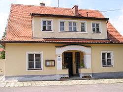
Protestant rectory | |||
| |||
 Javorník | |||
| Coordinates: 48°51′45″N 17°31′57″E / 48.86250°N 17.53250°ECoordinates: 48°51′45″N 17°31′57″E / 48.86250°N 17.53250°E | |||
| Country |
| ||
| Region | South Moravian | ||
| District | Hodonín | ||
| Area | |||
| • Total | 24.43 km2 (9.43 sq mi) | ||
| Elevation | 312 m (1,024 ft) | ||
| Population (2008) | |||
| • Total | 726 | ||
| • Density | 30/km2 (77/sq mi) | ||
| Postal code | 696 74 | ||
Javorník is a village and municipality (obec) in Hodonín District in the South Moravian Region of the Czech Republic.
The municipality covers an area of 24.43 square kilometres (9.43 sq mi), and has a population of 726 (as at 1 January 2008).
Javorník, a part of traditional ethnographic region Horňácko, lies approximately 30 kilometres (19 mi) east of Hodonín, 77 km (48 mi) south-east of Brno, and 263 km (163 mi) south-east of Prague.
References
| Wikimedia Commons has media related to Javorník (Hodonín District). |
This article is issued from Wikipedia - version of the 4/7/2016. The text is available under the Creative Commons Attribution/Share Alike but additional terms may apply for the media files.