Svatobořice-Mistřín
| Svatobořice-Mistřín | |||
| Village | |||
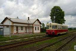 Disused train station in Svatobořice (2005) | |||
|
|||
| Country | Czech Republic | ||
|---|---|---|---|
| Region | South Moravian | ||
| District | Hodonín | ||
| Commune | Kyjov | ||
| River | Kyjovka | ||
| Elevation | 193 m (633 ft) | ||
| Coordinates | CZ 48°58′39″N 17°5′20″E / 48.97750°N 17.08889°ECoordinates: CZ 48°58′39″N 17°5′20″E / 48.97750°N 17.08889°E | ||
| Area | 23.11 km2 (8.92 sq mi) | ||
| Population | 3,553 (2007-12-31) | ||
| Density | 154/km2 (399/sq mi) | ||
| Merger | 1964 | ||
| Mayor | Ing. Jan Němčanský | ||
| Timezone | CET (UTC+1) | ||
| - summer (DST) | CEST (UTC+2) | ||
| Postal code | 696 04 | ||
  Location in the Czech Republic | |||
| Wikimedia Commons: Svatobořice-Mistřín | |||
| Statistics: statnisprava.cz | |||
| Website: www.svatoborice-mistrin.cz | |||

Svatobořice-Mistřín is a village and municipality in the South Moravian Region of the Czech Republic. It has around 3,500 inhabitants.
External links
- Municipal website (cz)
| Wikimedia Commons has media related to Svatobořice-Mistřín. |
This article is issued from Wikipedia - version of the 4/7/2016. The text is available under the Creative Commons Attribution/Share Alike but additional terms may apply for the media files.