Kamennogorsk
| Kamennogorsk (English) Каменногорск (Russian) | |
|---|---|
| - Town[1] - | |
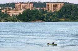 Panorama of Kamennogorsk across the Vuoksa River | |
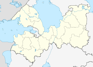
.svg.png) Location of Leningrad Oblast in Russia | |
 Kamennogorsk | |
|
| |
 | |
|
| |
| Administrative status (as of June 2013) | |
| Country | Russia |
| Federal subject | Leningrad Oblast[1] |
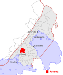
| Administrative district | Vyborgsky District[1] |
| Settlement municipal formation | Kamennogorskoye Settlement Municipal Formation[1] |
| Administrative center of | Kamennogorskoye Settlement Municipal Formation[1] |
| Municipal status (as of June 2013) | |
| Municipal district | Vyborgsky Municipal District[2] |
| Urban settlement | Kamennogorskoye Urban Settlement[2] |
| Administrative center of | Kamennogorskoye Urban Settlement[2] |
| Statistics | |
| Population (2010 Census) | 6,739 inhabitants[3] |
| Time zone | MSK (UTC+03:00)[4] |
| Town status since | 1940[5] |
| Previous names | Antrea (until October 1, 1948)[6] |
| Postal code(s)[7] | 188950 |
|
| |
| Kamennogorsk on Wikimedia Commons | |
Kamennogorsk (Russian: Каменного́рск), known under the Finnish name of Antrea (Russian: А́нтреа; Swedish: S:t Andree) before 1948, is a town in Vyborgsky District of Leningrad Oblast, Russia, located on the Karelian Isthmus on the left bank of the Vuoksa River (Lake Ladoga's basin) 170 kilometers (110 mi) northwest of St. Petersburg. Population: 6,739 (2010 Census);[3] 6,084 (2002 Census);[8] 5,694 (1989 Census).[9]
History
Human habitation in the area where Kamennogorsk now stands goes back to the Stone Age. In the beginning of the 20th century, a Stone Age site was discovered under a layer of peat. Findings at the site included wooden and flint implements, polished instruments of shale, remains of net of nettle fibers, sixteen fishing floats of piny bark, thirty-one stone plummets, a long bone dagger, and remains of nets with a length of 27 meters (89 ft) and a width of up to 3 meters (9.8 ft).
In the 14th-17th centuries, Antrea was a main administrative center of Karelian settlements on the upper Vuoksi. The name comes from Lutheran community founded in the 17th century and the church of St. Andrew.
In 1710, during the Great Northern War, the troops of Tsar Peter the Great included the whole area of the modern Vyborgsky District to Russia. In the course of Peter's second administrative reform, Antrea became a part of Vyborg Province of St. Petersburg Governorate. The 1721 Treaty of Nystad, which concluded the war with Sweden, finalized the transfer of this part of Old Finland to Russia.[10]
In 1744, Vyborg Governorate, with the seat in Vyborg, was established.[11] After several changes, Vyborg Governorate was renamed Finland Governorate in 1802.[11] In 1811, it was renamed back and included in the Grand Duchy of Finland, which was previously ceded to Russia by Sweden.[11] In Finland, it became known as the Viipuri Province. In 1918, the Viipuri Province became a part of independent Finland.[5]
Antrea, together with the rest of the Karelian Isthmus, was ceded by Finland to the Soviet Union by the Moscow Peace Treaty as a result of the Winter War. It was recaptured by Finns between 1941 and 1944 during Continuation War but was again ceded to the Soviet Union after Moscow Armistice. This secession was formalized after signing Paris Peace Treaty in 1947. The population was resettled to Finland, and population from Central Russia was resettled to populate the Karelian Isthmus.
In 1940, Antrea became a part of newly established was Yaskinsky District with the administrative center in the work settlement of Yaski. At the same time, it was granted town status.[5] At that time, it was a part of the Karelian ASSR (after March 30, 1940 of the Karelo-Finnish SSR).[12] On November 24, 1944, Yaskinsky District was transferred from Karelo-Finnish SSR to Leningrad Oblast.[6] To replace Finnish names of the localities with Russian names, on October 1, 1948, the district was renamed Lesogorsky and the town of Antrea was renamed Kamennogorsk.[6] The town's new name was due to the presence of crystalline deposit outcrops and a granite mine in the vicinity.[13] On December 9, 1960, Lesogorsky District was abolished and merged into Vyborgsky District.[6]
Administrative and municipal status
Within the framework of administrative divisions, it is, together with twenty-nine rural localities, incorporated within Vyborgsky District as Kamennogorskoye Settlement Municipal Formation.[1] As a municipal division, Kamennogorskoye Settlement Municipal Formation is incorporated within Vyborgsky Municipal District as Kamennogorskoye Urban Settlement.[2]
Economy
Industry
A large quarry for extraction of grey granite is situated in Kamennogorsk. Also there is an offset paper factory, which before the war was used for producing sugar from sugar beets.
Transportation
The town has a railway station on the railway line connecting Vyborg and Khiytola (the old Vyborg–Joensuu railroad). Another railway branches up north to Svetogorsk; the continuation beyond Svetogorsk to the Finnish–Russian border is disused. All these railways are served by suburban trains. A new railway to Sosnovo and Losevo is under construction.
The town is connected by roads with Vyborg, Svetogorsk, and Melnikovo.
Notable people
- Matti Kekki, agronomist and politician
- Antti Litja, actor
References
Notes
- 1 2 3 4 5 6 Oblast Law #32-oz
- 1 2 3 4 Law #17-oz
- 1 2 Russian Federal State Statistics Service (2011). "Всероссийская перепись населения 2010 года. Том 1" [2010 All-Russian Population Census, vol. 1]. Всероссийская перепись населения 2010 года (2010 All-Russia Population Census) (in Russian). Federal State Statistics Service. Retrieved June 29, 2012.
- ↑ Правительство Российской Федерации. Федеральный закон №107-ФЗ от 3 июня 2011 г. «Об исчислении времени», в ред. Федерального закона №271-ФЗ от 03 июля 2016 г. «О внесении изменений в Федеральный закон "Об исчислении времени"». Вступил в силу по истечении шестидесяти дней после дня официального опубликования (6 августа 2011 г.). Опубликован: "Российская газета", №120, 6 июня 2011 г. (Government of the Russian Federation. Federal Law #107-FZ of June 31, 2011 On Calculating Time, as amended by the Federal Law #271-FZ of July 03, 2016 On Amending Federal Law "On Calculating Time". Effective as of after sixty days following the day of the official publication.).
- 1 2 3 Энциклопедия Города России. Moscow: Большая Российская Энциклопедия. 2003. p. 176. ISBN 5-7107-7399-9.
- 1 2 3 4 Яскинский район (ноябрь 1944 г. - октябрь 1948 г.), Лесогорский район (октябрь 1948 г. - декабрь 1960 г.) (in Russian). Система классификаторов исполнительных органов государственной власти Санкт-Петербурга. Retrieved March 21, 2014.
- ↑ Почта России. Информационно-вычислительный центр ОАСУ РПО. (Russian Post). Поиск объектов почтовой связи (Postal Objects Search) (Russian)
- ↑ Russian Federal State Statistics Service (May 21, 2004). "Численность населения России, субъектов Российской Федерации в составе федеральных округов, районов, городских поселений, сельских населённых пунктов – районных центров и сельских населённых пунктов с населением 3 тысячи и более человек" [Population of Russia, Its Federal Districts, Federal Subjects, Districts, Urban Localities, Rural Localities—Administrative Centers, and Rural Localities with Population of Over 3,000] (XLS). Всероссийская перепись населения 2002 года [All-Russia Population Census of 2002] (in Russian). Retrieved August 9, 2014.
- ↑ Demoscope Weekly (1989). "Всесоюзная перепись населения 1989 г. Численность наличного населения союзных и автономных республик, автономных областей и округов, краёв, областей, районов, городских поселений и сёл-райцентров" [All Union Population Census of 1989: Present Population of Union and Autonomous Republics, Autonomous Oblasts and Okrugs, Krais, Oblasts, Districts, Urban Settlements, and Villages Serving as District Administrative Centers]. Всесоюзная перепись населения 1989 года [All-Union Population Census of 1989] (in Russian). Институт демографии Национального исследовательского университета: Высшая школа экономики [Institute of Demography at the National Research University: Higher School of Economics]. Retrieved August 9, 2014.
- ↑ История Выборгского района, история Выборгской земли (in Russian). Муниципальное образование Выборгский район Ленинградской Области. Retrieved March 20, 2014.
- 1 2 3 С. А. Тархов (2001). "Изменение административно-территориального деления России за последние 300 лет". Электронная версия журнала "География".
- ↑ Карело-Финская ССР (PDF) (in Russian). Handbook of administrative divisions of Soviet Union. Retrieved March 12, 2014.
- ↑ Pospelov, p. 28
Sources
- Законодательное собрание Ленинградской области. Областной закон №32-оз от 15 июня 2010 г. «Об административно-территориальном устройстве Ленинградской области и порядке его изменения», в ред. Областного закона №23-оз от 8 мая 2014 г. «Об объединении муниципальных образований "Приморское городское поселение" Выборгского района Ленинградской области и "Глебычевское сельское поселение" Выборгского района Ленинградской области и о внесении изменений в отдельные Областные законы». Вступил в силу со дня официального опубликования. Опубликован: "Вести", №112, 23 июня 2010 г. (Legislative Assembly of Leningrad Oblast. Oblast Law #32-oz of June 15, 2010 On the Administrative-Territorial Structure of Leningrad Oblast and on the Procedures for Its Change, as amended by the Oblast Law #23-oz of May 8, 2014 On Merging the Municipal Formations of "Primorskoye Urban Settlement" in Vyborgsky District of Leningrad Oblast and "Glebychevskoye Rural Settlement" in Vyborgsky District of Leningrad Oblast and on Amending Various Oblast Laws. Effective as of the day of the official publication.).
- Законодательное собрание Ленинградской области. Областной закон №17-оз от 10 марта 2004 г. «Об установлении границ и наделении соответствующим статусом муниципальных образований Всеволожский район и Выборгский район и муниципальных образований в их составе», в ред. Областного закона №23-оз от 8 мая 2014 г. «Об объединении муниципальных образований "Приморское городское поселение" Выборгского района Ленинградской области и "Глебычевское сельское поселение" Выборгского района Ленинградской области и о внесении изменений в отдельные Областные законы». Вступил в силу со дня официального опубликования. Опубликован: "Вести", №27, 11 марта 2004 г. (Legislative Assembly of Leningrad Oblast. Oblast Law #17-oz of March 10, 2004 On Establishing the Borders of and Granting an Appropriate Status to the Municipal Formations of Vsevolozhsky District and Vyborgsky District and to the Municipal Formations Comprising It, as amended by the Oblast Law #23-oz of May 8, 2014 On Merging the Municipal Formations of "Primorskoye Urban Settlement" in Vyborgsky District of Leningrad Oblast and "Glebychevskoye Rural Settlement" in Vyborgsky District of Leningrad Oblast and on Amending Various Oblast Laws. Effective as of the day of the official publication.).
- Е. М. Поспелов (Ye. M. Pospelov). "Имена городов: вчера и сегодня (1917–1992). Топонимический словарь." (City Names: Yesterday and Today (1917–1992). Toponymic Dictionary.) Москва, "Русские словари", 1993.
Administrative center: none | |||
| Cities and towns |
| ||
| Districts | |||