Slantsevsky District
| Slantsevsky District Сланцевский район (Russian) | |
|---|---|
.svg.png) Location of Slantsevsky District in Leningrad Oblast | |
| Coordinates: 59°07′N 28°05′E / 59.117°N 28.083°ECoordinates: 59°07′N 28°05′E / 59.117°N 28.083°E | |
.png) |
.png) |
|
| |
| Location | |
| Country | Russia |
| Federal subject | Leningrad Oblast[1] |
| Administrative structure (as of May 2012) | |
| Administrative center | town of Slantsy[1] |
| Administrative divisions:[1] | |
| settlement municipal formation | 6 |
| Inhabited localities:[1] | |
| Cities/towns | 1 |
| Rural localities | 155 |
| Municipal structure (as of May 2010) | |
| Municipally incorporated as | Slantsevsky Municipal District[2] |
| Municipal divisions:[2] | |
| Urban settlements | 1 |
| Rural settlements | 6 |
| Statistics | |
| Area | 2,191.1 km2 (846.0 sq mi)[3] |
| Population (2010 Census) | 10,038 inhabitants[4] |
| • Urban | 0% |
| • Rural | 100% |
| Density | 4.58/km2 (11.9/sq mi)[5] |
| Time zone | MSK (UTC+03:00)[6] |
| Official website | |
| Slantsevsky District on WikiCommons | |
Slantsevsky District (Russian: Сла́нцевский райо́н) is an administrative[1] and municipal[2] district (raion), one of the seventeen in Leningrad Oblast, Russia. It is located in the southwest of the oblast and borders with Ida-Viru County of Estonia in the west, Kingiseppsky District in the north, Volosovsky District in the northeast, Luzhsky District in the east, Plyussky District of Pskov Oblast in the south, and Gdovsky District, also of Pskov Oblast, in the southwest. The area of the district is 2,191.1 square kilometers (846.0 sq mi).[3] Its administrative center is the town of Slantsy.[1] Population (excluding the administrative center): 10,038 (2010 Census);[4] 10,480 (2002 Census);[7] 10,974 (1989 Census).[8]
Geography
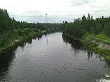
The area of the district is flat. Its western and southern parts belong to the drainage basin of the Narva River. The Narva flows at the border between Russia and Estonia, and in the northwestern part of the district is dammed and forms the Narva Reservoir. The largest tributary of the Narva within the district is the Plyussa. The eastern part of the district belongs to the basin of the Luga River, with the largest tributary of the Luga within the district being the Dolgaya River. The Luga itself forms the northeastern border of the district.
History
Originally, the area of the district was populated by Finnic peoples, eventually, the Slavs began arriving. After the 9th century, the eastern part of the area was dependent on the Novgorod Republic (from the 15th century, the Grand Duchy of Moscow), and the western part belonged to Pskov. The area was constantly at the frontier and became the battleground between Germans and Swedes, on one side, and Russians, on the other side. It was desolated during the Livonian War. In 1617, according to the Treaty of Stolbovo, the west of the area was transferred to Sweden, and in the 1700s, during the Great Northern War, it was conquered back by Russia.[9]
In the course of the administrative reform carried out in 1708 by Peter the Great, the area was included into Ingermanland Governorate (known since 1710 as Saint Petersburg Governorate). Later on, Gdovsky Uyezd with the administrative center in Gdov was established, and the area was a part of Gdovsky Uyezd.[9] The governorate was renamed Petrograd in 1914 and Leningrad in 1924. In 1919, Gdovsky Uyezd was an area where important events of the Russian Civil War and the Estonian War of Independence were taking place. Originally, the area east of the Narva was under control of the revolutionary government. On May 15, 1919, the detachment under command of Stanislav Bulak-Balakhovich captured Gdov, and the whole uyezd thus came under control of the Yudenich's White Army troops. In November 1919, the Red Army recaptured Gdov.[10]
On August 1, 1927, the uyezds were abolished, and Gdovsky District was established, with the administrative center in the town of Gdov. It included parts of former Gdovsky Uyezd. The governorates were abolished as well, and the district became a part of Luga Okrug of Leningrad Oblast. On July 23, 1930, the okrugs were abolished as well, and the districts were directly subordinated to the oblast. Between March 22, 1935 and September 19, 1940, Gdovsky District was a part of Pskov Okrug of Leningrad Oblast, one of the okrugs abutting the state boundaries of the Soviet Union.
On March 11, 1941, Slantsevsky District, with the administrative center in the urban-type settlement of Slantsy, was split from Gdovsky District. One selsoviet from Kingiseppsky District was transferred to newly established Slantsevsky District.[11] Between August 1941, and February 1944, Slantsevsky District was occupied by German troops.[12] In February 1944, the Kingisepp–Gdov Offensive, a military operation in which the Soviet Army advanced to the east bank of the Narva and of Lake Peipus, took place here.
The areas adjacent to the Narva River were assigned to Estonia in 1920, following the Estonian War of Independence and the Treaty of Tartu, signed on February 2, 1920. On November 24, 1944 this area was transferred to Leningrad Oblast and shared between Slantsevsky (south) and Kingiseppsky (north) Districts.[12]
On April 5, 1949 Slantsy was granted town status. On January 1, 1963 Slantsevsky District was abolished and split between Kingiseppsky and Luzhsky Districts. On November 3, 1965 it was re-established and included some of the areas previously transferred to Kingiseppsky District.[12]
On August 1, 1927 Osminsky District with the administrative center in the selo of Osmino was established as well. It was s part of Luga Okrug of Leningrad Oblast. It included areas which were previously parts of Gdovsky, Luzhsky, and Kingiseppsky Uyezds. On July 23, 1930, the okrugs were abolished, and the districts were directly subordinated to the oblast. Between March 22, 1935 and September 19, 1940, Osminsky District was a part of Kingisepp Okrug of Leningrad Oblast, one of the okrugs abutting the state boundaries of the Soviet Union. Between August 1941, and February 1944, Osminsky District was occupied by German troops. On August 2, 1961 Osminsky District was abolished and split between Slantsevsky and Volosovsky Districts.[13] After the abortive administrative reform of the 1960s, its territory became split between Slantsevsky, Volosovsky, Luzhsky, and Kingiseppsky Districts.[12]
Another district established on August 1, 1927 was Rudnensky District, with the administrative center in the selo of Rudno. It included parts of former Gdovsky Uyezd. The district was a part of Luga Okrug of Leningrad Oblast. On August 30, 1930, the administrative center of the district was transferred to the village of Vyskatka. On August 10, 1933, Rudnensky District was abolished and split between Gdovsky and Osminsky Districts. Its area is currently split between Gdovsky and Slantsevsky Districts.[14]
Restricted access
The western part of the district, a strip along the Narva River, is included into the border security zone, intended to protect the borders of Russia from unwanted activity. In order to visit the zone, a permit issued by the local Federal Security Service department is required.[15]
Economy
Industry
In the district, there are construction industry (including several cement plants), chemical industry, and food industry enterprises.[16] The district has considerable deposits of Oil shale, one of the most important in Russia. In fact the name Slantsy in Russian means oil shale.
Agriculture
The main specialization of agriculture in the district is cattle breeding with meat and milk productions. As of 2012, there were for large-scale farms in the district, as well as one trout farm.[17]
Transportation
A railway connects Slantsy with Gdov in the south and with Veymarn in the north. Originally, the railway connected Pskov with Veymarn. It was destroyed during World War II, and the stretch between Gdov and Pskov was never rebuilt.
Slantsy is connected by roads with Pskov via Gdov and with Kingisepp. There are also local roads, with bus traffic originating from Slantsy.
Culture and recreation
The district contains thirty-seven objects classified as cultural and historical heritage of local significance (four of them in the town of Slantsy).[18] Most of those commemorate events related to World War II.
The Slantsy Museum of History and Culture, located in the town of Slantsy and focusing on the history of the town, is the only state museum in the district.[19]
References
Notes
- 1 2 3 4 5 6 Oblast Law #32-oz
- 1 2 3 Law #47-oz
- 1 2 Общая характеристика района (in Russian). Администрация Сланцевского муниципального района. Retrieved 5 March 2013.
- 1 2 Russian Federal State Statistics Service (2011). "Всероссийская перепись населения 2010 года. Том 1" [2010 All-Russian Population Census, vol. 1]. Всероссийская перепись населения 2010 года (2010 All-Russia Population Census) (in Russian). Federal State Statistics Service. Retrieved June 29, 2012.
- ↑ The value of density was calculated automatically by dividing the 2010 Census population by the area specified in the infobox. Please note that this value is only approximate as the area specified in the infobox does not necessarily correspond to the area of the entity proper or is reported for the same year as the population.
- ↑ Правительство Российской Федерации. Федеральный закон №107-ФЗ от 3 июня 2011 г. «Об исчислении времени», в ред. Федерального закона №271-ФЗ от 03 июля 2016 г. «О внесении изменений в Федеральный закон "Об исчислении времени"». Вступил в силу по истечении шестидесяти дней после дня официального опубликования (6 августа 2011 г.). Опубликован: "Российская газета", №120, 6 июня 2011 г. (Government of the Russian Federation. Federal Law #107-FZ of June 31, 2011 On Calculating Time, as amended by the Federal Law #271-FZ of July 03, 2016 On Amending Federal Law "On Calculating Time". Effective as of after sixty days following the day of the official publication.).
- ↑ Russian Federal State Statistics Service (May 21, 2004). "Численность населения России, субъектов Российской Федерации в составе федеральных округов, районов, городских поселений, сельских населённых пунктов – районных центров и сельских населённых пунктов с населением 3 тысячи и более человек" [Population of Russia, Its Federal Districts, Federal Subjects, Districts, Urban Localities, Rural Localities—Administrative Centers, and Rural Localities with Population of Over 3,000] (XLS). Всероссийская перепись населения 2002 года [All-Russia Population Census of 2002] (in Russian). Retrieved August 9, 2014.
- ↑ Demoscope Weekly (1989). "Всесоюзная перепись населения 1989 г. Численность наличного населения союзных и автономных республик, автономных областей и округов, краёв, областей, районов, городских поселений и сёл-райцентров" [All Union Population Census of 1989: Present Population of Union and Autonomous Republics, Autonomous Oblasts and Okrugs, Krais, Oblasts, Districts, Urban Settlements, and Villages Serving as District Administrative Centers]. Всесоюзная перепись населения 1989 года [All-Union Population Census of 1989] (in Russian). Институт демографии Национального исследовательского университета: Высшая школа экономики [Institute of Demography at the National Research University: Higher School of Economics]. Retrieved August 9, 2014.
- 1 2 История Сланцевского района (in Russian). Администрация Сланцевского муниципального района. Retrieved 6 March 2013.
- ↑ Ратьковский, И.С.; Ходяков М.В. (2001). История Советской России (in Russian). Лань. Retrieved June 6, 2012.
- ↑ Гдовский район (авг. 1927 - авг. 1944) (in Russian). Справочник истории административно-территориального деления Ленинградской области. Retrieved June 6, 2012.
- 1 2 3 4 Сланцевский район (март 1941 - февр. 1963, нояб. 1965) (in Russian). Система классификаторов исполнительных органов государственной власти Санкт-Петербурга. Retrieved March 7, 2013.
- ↑ Осьминский район (авг. 1927 - авг. 1961) (in Russian). Система классификаторов исполнительных органов государственной власти Санкт-Петербурга. Retrieved March 7, 2013.
- ↑ Рудненский район (август 1927 г. - август 1933 г.) (in Russian). Справочник истории административно-территориального деления Ленинградской области. Retrieved June 6, 2012.
- ↑ "Приказ ФСБ РФ от 2 июня 2006 года N 239 "О пределах пограничной зоны на территории Ленинградской области"; Приказ ФСБ РФ от 5 мая 2007 г. N 222 "О внесении изменений в Приказ ФСБ РФ ОТ 2 июня 2006 Г. N 239 "О пределах пограничной зоны на территории Ленинградской области""". Rossiyskaya Gazeta (in Russian). 2006.
- ↑ Экономика (in Russian). Администрация Сланцевского муниципального района. Retrieved 6 March 2013.
- ↑ Сельское хозяйство (in Russian). Администрация Сланцевского муниципального района. Retrieved 6 March 2013.
- ↑ Памятники истории и культуры народов Российской Федерации (in Russian). Russian Ministry of Culture. Retrieved 2 June 2016.
- ↑ Сланцевский историко-краеведческий музей (in Russian). Российская сеть культурного наследия. Retrieved 12 March 2013.
Sources
- Законодательное собрание Ленинградской области. Областной закон №32-оз от 15 июня 2010 г. «Об административно-территориальном устройстве Ленинградской области и порядке его изменения», в ред. Областного закона №23-оз от 8 мая 2014 г. «Об объединении муниципальных образований "Приморское городское поселение" Выборгского района Ленинградской области и "Глебычевское сельское поселение" Выборгского района Ленинградской области и о внесении изменений в отдельные Областные законы». Вступил в силу со дня официального опубликования. Опубликован: "Вести", №112, 23 июня 2010 г. (Legislative Assembly of Leningrad Oblast. Oblast Law #32-oz of June 15, 2010 On the Administrative-Territorial Structure of Leningrad Oblast and on the Procedures for Its Change, as amended by the Oblast Law #23-oz of May 8, 2014 On Merging the Municipal Formations of "Primorskoye Urban Settlement" in Vyborgsky District of Leningrad Oblast and "Glebychevskoye Rural Settlement" in Vyborgsky District of Leningrad Oblast and on Amending Various Oblast Laws. Effective as of the day of the official publication.).
- Законодательное собрание Ленинградской области. Областной закон №47-оз от 1 сентября 2004 г. «Об установлении границ и наделении соответствующим статусом муниципального образования Сланцевский муниципальный район и муниципальных образований в его составе», в ред. Областного закона №17-оз от 6 мая 2010 г «О внесении изменений в некоторые областные законы в связи с принятием федерального закона "О внесении изменений в отдельные законодательные акты Российской Федерации в связи с совершенствованием организации местного самоуправления"». Вступил в силу через 10 дней со дня официального опубликования (24 сентября 2004 г.). Опубликован: "Вестник Правительства Ленинградской области", №27, 14 сентября 2004 г. (Legislative Assembly of Leningrad Oblast. Oblast Law #47-oz of September 1, 2004 On Establishing the Borders of and Granting an Appropriate Status to the Municipal Formation of Slantsevsky Municipal District and to the Municipal Formations Comprised By It, as amended by the Oblast Law #17-oz of May 6, 2010 On Amending Various Oblast Laws Due to the Adoption of the Federal Law "On Amending Various Legislative Acts of the Russian Federation Due to the Improvement of the Organization of the Local Self-Government". Effective as of after 10 days from the day of the official publication (September 24 2004).).
Administrative center: none | |||
| Cities and towns |
| ||
| Districts | |||