Priozersky District
| Priozersky District Приозерский район (Russian) | |
|---|---|
.svg.png) Location of Priozersky District in Leningrad Oblast | |
| Coordinates: 61°02′N 30°07′E / 61.033°N 30.117°ECoordinates: 61°02′N 30°07′E / 61.033°N 30.117°E | |
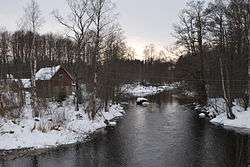 The Tikhaya River near Brigadnoye in Priozersky District | |
.png) | |
|
| |
| Location | |
| Country | Russia |
| Federal subject | Leningrad Oblast[1] |
| Administrative structure (as of May 2012) | |
| Administrative center | town of Priozersk[1] |
| Administrative divisions:[1] | |
| settlement municipal formation | 12 |
| Inhabited localities:[1] | |
| Cities/towns | 1 |
| Urban-type settlements[2] | 1 |
| Rural localities | 101 |
| Municipal structure (as of May 2010) | |
| Municipally incorporated as | Priozersky Municipal District[3] |
| Municipal divisions:[3] | |
| Urban settlements | 2 |
| Rural settlements | 12 |
| Statistics | |
| Area (municipal district) | 3,579.5 km2 (1,382.1 sq mi)[4] |
| Population (2010 Census) | 43,260 inhabitants[5] |
| • Urban | 10.3% |
| • Rural | 89.7% |
| Density | 12.09/km2 (31.3/sq mi)[6] |
| Time zone | MSK (UTC+03:00)[7] |
| Official website | |
| Priozersky District on WikiCommons | |
Priozersky District (Russian: Приозе́рский райо́н) is an administrative[1] and municipal[3] district (raion), one of the seventeen in Leningrad Oblast, Russia. It is located in the northwest of the oblast and borders with Lakhdenpokhsky District of the Republic of Karelia in the north, Vsevolozhsky District in the south, and Vyborgsky District in the west. In the east, the district is bounded by Lake Ladoga. The area of the district is 3,597.5 square kilometers (1,389.0 sq mi).[4] Its administrative center is the town of Priozersk.[1] Population (excluding the administrative center): 43,260 (2010 Census);[5] 42,859 (2002 Census);[8] 40,231 (1989 Census).[9].
Geography
The area of the district is elongated from north to south along the shore of Lake Ladoga. It completely belongs to the catchment area of Lake Ladoga, with the biggest river being the Vuoksi. The landscapes are typical for Kartelian Isthmus, with the hilly and rocky terrain covered by coniferous forest, and with many lakes. The biggest lakes in the district are Lake Vuoksa, Lake Sukhodolskoye, and Lake Otradnoye. Konevets Island on Lake Ladoga also belongs to the district. Forests occupy 63% of the area of the district.[4]
History
The territory of the modern district was originally settled by Karelians around the 1st century CE. It was a part of the Kievan Rus' from the 9th to 12th century. After that, it was a part the Novgorod Republic. Most Karelians were converted to the Russian Orthodox faith during Russian rule. Russians built the fortress of Korela, which was a nucleus of modern Priozersk. The territory passed hands many times during the 16th and 17th centuries between Russians and Swedish, until it was finally claimed by Russians in 1711 during the Great Northern War. During Swedish rule in the area, the town was known by its Swedish name Kexholm, which in Russian became Keksgolm.[4] In the 18th century, it was a part of Saint Petersburg Governorate, and later of Vyborg Governorate, which in 1812 was included in the newly created Grand Duchy of Finland as its Viipuri Province. It became part of independent Finland, when the former Grand Duchy declared its independence in December 1917. During the Interwar Period, the location was known by its Finnish and Swedish names; Käkisalmi (Finnish) and Kexholm (Swedish).
The area was ceded from Finland to the Soviet Union as a result of the 1939-40 Winter War. It was retaken by Finland during the 1941-44 Continuation War, regained by Soviet troops in 1944, and formally ceded to the Soviet Union in 1947. Nearly all of Finnish residents evacuated the area, which was repopulated by Russians, Ukrainians, and Belarusians. Place names were changed in 1948 to remove remaining Finnish names in the district.
Keksgolmsky District with the administrative center in Keksgolm was established in March 1940 as a part of the Karelian Autonomous Soviet Socialist Republic (Karelian ASSR). On March 31, 1940, the Karelian ASSR was transformed into the Karelo-Finnish Soviet Socialist Republic. On November 24, 1944, Keksgolmsky District was transferred from Karelo-Finnish Soviet Socialist Republic to Leningrad Oblast. On October 1, 1948, the district was renamed Priozersky, and Keksgolm was renamed Priozersk. On February 1, 1963 the district was abolished and merged into Vyborgsky District; on January 12, 1965 it was re-esteblished.[10]
On May 16, 1940, Rautovsky District with the administrative center in the suburban settlement of Rautu was also established. It was a part of Leningrad Oblast. On October 1, 1948, the district was renamed Sosnovsky and on January 13, 1949, all localities whose names originated in Finnish were renamed using Russian names. In particular, Rautu was renamed Sosnovo. On December 9, 1960, Sosnovsky District was abolished and split between Roshchinsky and Priozersky Districts.[11]
Economy
Industry
Industry in the district is dominated by the treatment of granite, timber production, and food production.[4]
Agriculture
The main specializations of agriculture in the district are meat (beef and pork) and milk production, as well as trout farming.[4]
Transportation
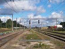
The Saint Petersburg – Hiitola railroad crosses the district from south to north passing Sosnovo, Priozersk, and Kuznechnoye. There is passenger service from the Finland Station of Saint Petersburg. Another railroad, connecting Vyborg with Hiitola via Kamennogorsk, serves as a stretch of the border with Vyborgsky District.
The road network in the district is relatively well-connected and provides access to Vyborg, Sortavala, and Saint Petersburg. In particular, the A129 highway connects Saint Petersburg and Sortavala and runs through Priozersk.
Culture and recreation
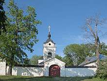
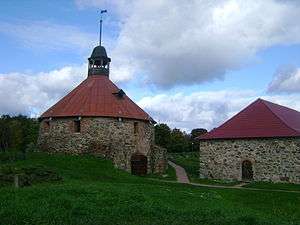
Some remains of the pre-1917 Russian culture, including the Korela Fortress in Priozersk and the Konevsky Monastery at Konevets Island, survive. Much of the remnants of the Finnish presence was destroyed. The district is the most popular with tourists part of Karelian Isthmus.
The district contains 64 cultural heritage monuments of federal significance (33 of which are in Priozersk) and additionally 70 objects classified as cultural and historical heritage of local significance.[12] The great majority of these monuments belong to the Korela fortress and the Konevets Island.
References
Notes
- 1 2 3 4 5 6 Oblast Law #32-oz
- ↑ The count of urban-type settlements may include the work settlements, the resort settlements, the suburban (dacha) settlements, as well as urban-type settlements proper.
- 1 2 3 Law #50-oz
- 1 2 3 4 5 6 Приозерский муниципальный район (in Russian). Администрация муниципального образования Приозерский муниципальный район Ленинградской области. Retrieved 18 June 2013.
- 1 2 Russian Federal State Statistics Service (2011). "Всероссийская перепись населения 2010 года. Том 1" [2010 All-Russian Population Census, vol. 1]. Всероссийская перепись населения 2010 года (2010 All-Russia Population Census) (in Russian). Federal State Statistics Service. Retrieved June 29, 2012.
- ↑ The value of density was calculated automatically by dividing the 2010 Census population by the area specified in the infobox. Please note that this value is only approximate as the area specified in the infobox does not necessarily correspond to the area of the entity proper or is reported for the same year as the population.
- ↑ Правительство Российской Федерации. Федеральный закон №107-ФЗ от 3 июня 2011 г. «Об исчислении времени», в ред. Федерального закона №271-ФЗ от 03 июля 2016 г. «О внесении изменений в Федеральный закон "Об исчислении времени"». Вступил в силу по истечении шестидесяти дней после дня официального опубликования (6 августа 2011 г.). Опубликован: "Российская газета", №120, 6 июня 2011 г. (Government of the Russian Federation. Federal Law #107-FZ of June 31, 2011 On Calculating Time, as amended by the Federal Law #271-FZ of July 03, 2016 On Amending Federal Law "On Calculating Time". Effective as of after sixty days following the day of the official publication.).
- ↑ Russian Federal State Statistics Service (May 21, 2004). "Численность населения России, субъектов Российской Федерации в составе федеральных округов, районов, городских поселений, сельских населённых пунктов – районных центров и сельских населённых пунктов с населением 3 тысячи и более человек" [Population of Russia, Its Federal Districts, Federal Subjects, Districts, Urban Localities, Rural Localities—Administrative Centers, and Rural Localities with Population of Over 3,000] (XLS). Всероссийская перепись населения 2002 года [All-Russia Population Census of 2002] (in Russian). Retrieved August 9, 2014.
- ↑ Demoscope Weekly (1989). "Всесоюзная перепись населения 1989 г. Численность наличного населения союзных и автономных республик, автономных областей и округов, краёв, областей, районов, городских поселений и сёл-райцентров" [All Union Population Census of 1989: Present Population of Union and Autonomous Republics, Autonomous Oblasts and Okrugs, Krais, Oblasts, Districts, Urban Settlements, and Villages Serving as District Administrative Centers]. Всесоюзная перепись населения 1989 года [All-Union Population Census of 1989] (in Russian). Институт демографии Национального исследовательского университета: Высшая школа экономики [Institute of Demography at the National Research University: Higher School of Economics]. Retrieved August 9, 2014.
- ↑ Кексгольмский район (нояб. 1944 - окт.1948), Приозерский район (окт.1948 – февр.1963, янв.1965) (in Russian). Система классификаторов исполнительных органов государственной власти Санкт-Петербурга. Retrieved June 20, 2013.
- ↑ Раутовский район (май 1940 г. - октябрь 1948 г.), Сосновский район (октябрь 1948 г. - дек. 1960) (in Russian). Система классификаторов исполнительных органов государственной власти Санкт-Петербурга. Retrieved June 19, 2013.
- ↑ Памятники истории и культуры народов Российской Федерации (in Russian). Russian Ministry of Culture. Retrieved 2 June 2016.
Sources
- Законодательное собрание Ленинградской области. Областной закон №32-оз от 15 июня 2010 г. «Об административно-территориальном устройстве Ленинградской области и порядке его изменения», в ред. Областного закона №23-оз от 8 мая 2014 г. «Об объединении муниципальных образований "Приморское городское поселение" Выборгского района Ленинградской области и "Глебычевское сельское поселение" Выборгского района Ленинградской области и о внесении изменений в отдельные Областные законы». Вступил в силу со дня официального опубликования. Опубликован: "Вести", №112, 23 июня 2010 г. (Legislative Assembly of Leningrad Oblast. Oblast Law #32-oz of June 15, 2010 On the Administrative-Territorial Structure of Leningrad Oblast and on the Procedures for Its Change, as amended by the Oblast Law #23-oz of May 8, 2014 On Merging the Municipal Formations of "Primorskoye Urban Settlement" in Vyborgsky District of Leningrad Oblast and "Glebychevskoye Rural Settlement" in Vyborgsky District of Leningrad Oblast and on Amending Various Oblast Laws. Effective as of the day of the official publication.).
- Законодательное собрание Ленинградской области. Областной закон №50-оз от 1 сентября 2004 г. «Об установлении границ и наделении соответствующим статусом муниципального образования Приозерский муниципальный район и муниципальных образований в его составе», в ред. Областного закона №43-оз от 27 июня 2013 г. «О присоединении деревни Большая Загвоздка к городу Гатчина и о внесении изменений в некоторые Областные законы в сфере административно-территориального устройства Ленинградской области». Вступил в силу через 10 дней со дня официального опубликования (24 сентября 2004 г.). Опубликован: "Вестник Правительства Ленинградской области", №27, 14 сентября 2004 г. (Legislative Assembly of Leningrad Oblast. Oblast Law #50-oz of September 1, 2004 On Establishing the Borders of and Granting an Appropriate Status to the Municipal Formation of Priozersky Municipal District and to the Municipal Formations Comprised By It, as amended by the Oblast Law #43-oz of June 27, 2013 On Merging the Village of Bolshaya Zagvozdka into the Town of Gatchina and on Amending Various Oblast Laws on the Subject of the Administrative-Territorial Structure of Leningrad Oblast. Effective as of after 10 days from the day of the official publication (September 24 2004).).
Administrative center: none | |||
| Cities and towns |
| ||
| Districts | |||