LaSalle Parish, Louisiana
| LaSalle Parish, Louisiana | |
|---|---|
|
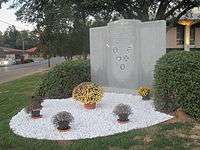
The La Salle Parish Courthouse in Jena | |
 Location in the U.S. state of Louisiana | |
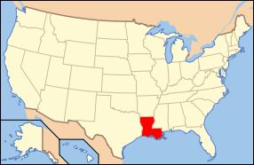 Louisiana's location in the U.S. | |
| Founded | January 1, 1910 |
| Named for | René-Robert Cavelier, Sieur de La Salle |
| Seat | Jena |
| Largest town | Jena |
| Area | |
| • Total | 662 sq mi (1,715 km2) |
| • Land | 625 sq mi (1,619 km2) |
| • Water | 38 sq mi (98 km2), 5.7% |
| Population | |
| • (2010) | 14,890 |
| • Density | 24/sq mi (9/km²) |
| Congressional district | 5th |
| Time zone | Central: UTC-6/-5 |

LaSalle Parish (French: Paroisse de La Salle) is a parish located in the U.S. state of Louisiana. As of the 2010 census, the population was 14,890.[1] The parish seat is Jena.[2] The parish was created in 1910 from the western section of Catahoula Parish and named for René-Robert Cavelier, Sieur de La Salle.[3]
Geography
According to the U.S. Census Bureau, the parish has a total area of 662 square miles (1,710 km2), of which 625 square miles (1,620 km2) is land and 38 square miles (98 km2) (5.7%) is water.[4]
Major highways
Adjacent parishes
- Caldwell Parish (north)
- Catahoula Parish (east)
- Avoyelles Parish (south)
- Rapides Parish (southwest)
- Grant Parish (west)
- Winn Parish (northwest)
National protected area
Demographics
| Historical population | |||
|---|---|---|---|
| Census | Pop. | %± | |
| 1910 | 9,402 | — | |
| 1920 | 9,856 | 4.8% | |
| 1930 | 11,668 | 18.4% | |
| 1940 | 10,959 | −6.1% | |
| 1950 | 12,717 | 16.0% | |
| 1960 | 13,011 | 2.3% | |
| 1970 | 13,295 | 2.2% | |
| 1980 | 17,004 | 27.9% | |
| 1990 | 13,662 | −19.7% | |
| 2000 | 14,282 | 4.5% | |
| 2010 | 14,890 | 4.3% | |
| Est. 2015 | 14,974 | [5] | 0.6% |
| U.S. Decennial Census[6] 1790-1960[7] 1900-1990[8] 1990-2000[9] 2010-2013[1] | |||
As of the census[10] of 2000, there were 14,282 people, 5,291 households, and 3,798 families residing in the parish. The population density was 23 people per square mile (9/km²). There were 6,273 housing units at an average density of 10 per square mile (4/km²). The racial makeup of the parish was 86.13% White, 12.20% Black or African American, 0.64% Native American, 0.18% Asian, 0.01% Pacific Islander, 0.20% from other races, and 0.64% from two or more races. 0.82% of the population were Hispanic or Latino of any race.
There were 5,291 households, out of which 33.60% had children under the age of 18 living with them, 59.00% were married couples living together, 9.80% had a female householder with no husband present, and 28.20% were non-families. 25.70% of all households were made up of individuals and 13.00% had someone living alone who was 65 years of age or older. The average household size was 2.52 and the average family size was 3.03.
In the parish the population was spread out with 26.10% under the age of 18, 9.40% from 18 to 24, 27.20% from 25 to 44, 22.60% from 45 to 64, and 14.80% who were 65 years of age or older. The median age was 36 years. For every 100 females there were 100.30 males. For every 100 females age 18 and over, there were 97.20 males.
The median income for a household in the parish was $28,189, and the median income for a family was $36,197. Males had a median income of $27,431 versus $19,697 for females. The per capita income for the parish was $14,033. About 14.90% of families and 18.70% of the population were below the poverty line, including 23.70% of those under age 18 and 18.90% of those age 65 or over.
National Guard
The 1087TH Transportation Company of the 165TH CSS (combat service support) Battalion of the 139TH RSG (regional support group) resides in Jena, Louisiana.
Communities
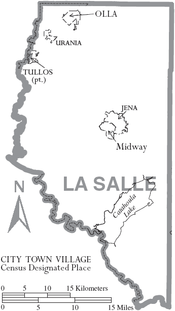
Towns
Unincorporated communities
Notable residents
- Evelyn Blackmon, born in Standard in 1924; Democratic member of the Louisiana House of Representatives from 1984 to 1988 from West Monroe; Realtor for a half century[11]
- Thomas "Bud" Brady, member of the Louisiana House of Representatives from 1976 to 1988
- U. T. Downs, sheriff of Rapides Parish, 1924-1940; mayor of Pineville, 1914-1924, born in LaSalle Parish in 1880[12]
- Mike Francis, former Louisiana Republican state chairman
- Henry E. Hardtner, lumberman known as "Louisiana's first conservationist", member of both houses of the Louisiana State Legislature, LaSalle Parish police juror, founder of Urania
- Speedy O. Long, state senator, U.S. representative, district attorney
- Lula V. Coleman, 1918 first female deputy sheriff in State of Louisiana, 1920 appointed first female mayor in Louisiana for Jena, LA. (parish seat) by Governor Parker
See also
References
- 1 2 "La Salle Parish, Louisiana". quickfacts.census.gov. Retrieved July 4, 2013.
- ↑ "Find a County". National Association of Counties. Retrieved 2011-06-07.
- ↑ "La Salle Parish". Center for Cultural and Eco-Tourism. Retrieved September 4, 2014.
- ↑ "2010 Census Gazetteer Files". United States Census Bureau. August 22, 2012. Retrieved September 1, 2014.
- ↑ "County Totals Dataset: Population, Population Change and Estimated Components of Population Change: April 1, 2010 to July 1, 2015". Retrieved July 2, 2016.
- ↑ "U.S. Decennial Census". United States Census Bureau. Retrieved September 1, 2014.
- ↑ "Historical Census Browser". University of Virginia Library. Retrieved September 1, 2014.
- ↑ "Population of Counties by Decennial Census: 1900 to 1990". United States Census Bureau. Retrieved September 1, 2014.
- ↑ "Census 2000 PHC-T-4. Ranking Tables for Counties: 1990 and 2000" (PDF). United States Census Bureau. Retrieved September 1, 2014.
- ↑ "American FactFinder". United States Census Bureau. Retrieved 2008-01-31.
- ↑ "Evelyn Blackmon obituary". Monroe News-Star. Retrieved May 23, 2014.
- ↑ Henry E. Chambers, A History of Louisiana: Wilderness, Colony, Province, Territory, State, People, (Chicago and New York City: American Historical Society, Inc., 1925), pp. 245-246
External links
Municipalities and communities of LaSalle Parish, Louisiana, United States | ||
|---|---|---|
| Towns | | |
| CDP | ||
| Unincorporated communities | ||
| Footnotes | ‡This populated place also has portions in an adjacent parish or parishes | |
Coordinates: 31°41′N 92°10′W / 31.68°N 92.16°W