Lassay-les-Châteaux
| Lassay-les-Châteaux | ||
|---|---|---|
|
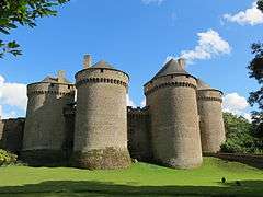
View of Lassay-les-Châteaux. The medieval castle is visible on the left. | ||
| ||
 Lassay-les-Châteaux | ||
|
Location within Pays de la Loire region  Lassay-les-Châteaux | ||
| Coordinates: 48°26′18″N 0°29′40″W / 48.4383°N 0.4944°WCoordinates: 48°26′18″N 0°29′40″W / 48.4383°N 0.4944°W | ||
| Country | France | |
| Region | Pays de la Loire | |
| Department | Mayenne | |
| Arrondissement | Mayenne | |
| Canton | Lassay-les-Châteaux | |
| Government | ||
| • Mayor (2008–2014) | Jean-Michel Crinière | |
| Area1 | 57.63 km2 (22.25 sq mi) | |
| Population (2006)2 | 2,450 | |
| • Density | 43/km2 (110/sq mi) | |
| Time zone | CET (UTC+1) | |
| • Summer (DST) | CEST (UTC+2) | |
| INSEE/Postal code | 53127 / 53110 | |
| Elevation |
98–270 m (322–886 ft) (avg. 205 m or 673 ft) | |
|
1 French Land Register data, which excludes lakes, ponds, glaciers > 1 km² (0.386 sq mi or 247 acres) and river estuaries. 2 Population without double counting: residents of multiple communes (e.g., students and military personnel) only counted once. | ||


Lassay-les-Châteaux is a commune in the Mayenne department in north-western France.
Monuments

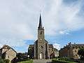 Church.
See also
| Wikimedia Commons has media related to Lassay-les-Châteaux. |
This article is issued from Wikipedia - version of the 11/19/2016. The text is available under the Creative Commons Attribution/Share Alike but additional terms may apply for the media files.