Laurens (town), New York
Laurens is a town in Otsego County, New York, United States. The population was 2,424 at the 2010 census.
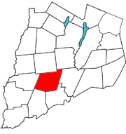
The Town of Laurens is in the south half of the county, north of the City of Oneonta. There is also a village named Laurens, located in the town.
History
The town was first settled by Europeans around 1773. Joseph Mayall arrived in 1773 about one mile north of the present Laurens village. The raiding party responsible for the Cherry Valley Massacre also pillaged part of Laurens and burned some property.
The town was formed from the Town of Otsego in 1810. It was named for Revolutionary War hero Henry Laurens.[1]
A resort developed by the Oneonta Mohawk trolley line called Otsego Park was formerly located in the eastern part of Laurens. Cotton mills once were an industry in Laurens, powered by the water of Gilbert Lake.
Laurens Central School is renowned for its excellent concert band, jazz band, and color guard.
Notable people
- Mel Gibson, actor, lived in the hamlet of Mount Vision and attended Laurens Central School before moving to Australia when he was a child.
- Perry G. Harrington, Wisconsin State Assemblyman, was born in the town.
- Mary Whitcher, a Shaker trustee, schoolteacher, and author at the Canterbury Shaker Village was born in the town.
Geography
According to the United States Census Bureau, the town has a total area of 42.7 square miles (110.5 km²), of which, 42.6 square miles (110.3 km²) of it is land and 0.1 square miles (0.3 km²) of it (0.23%) is water.
Otego Creek flows southward through the eastern part of Laurens.
A sulfur spring is located about a mile north of Laurens village.
New York State Route 205, a north-south highway, follows the course of Otsego Creek. New York State Route 23, an east-west highway, passes through the center of the town.
Demographics
| Historical population | |||
|---|---|---|---|
| Census | Pop. | %± | |
| 1820 | 2,074 | — | |
| 1830 | 2,231 | 7.6% | |
| 1840 | 2,173 | −2.6% | |
| 1850 | 2,168 | −0.2% | |
| 1860 | 1,936 | −10.7% | |
| 1870 | 1,919 | −0.9% | |
| 1880 | 1,827 | −4.8% | |
| 1890 | 1,659 | −9.2% | |
| 1900 | 1,483 | −10.6% | |
| 1910 | 1,453 | −2.0% | |
| 1920 | 1,335 | −8.1% | |
| 1930 | 1,423 | 6.6% | |
| 1940 | 1,395 | −2.0% | |
| 1950 | 1,447 | 3.7% | |
| 1960 | 1,498 | 3.5% | |
| 1970 | 1,730 | 15.5% | |
| 1980 | 2,101 | 21.4% | |
| 1990 | 2,349 | 11.8% | |
| 2000 | 2,402 | 2.3% | |
| 2010 | 2,424 | 0.9% | |
| Est. 2014 | 2,372 | [2] | −2.1% |
As of the census[4] of 2000, there were 2,402 people, 965 households, and 692 families residing in the town. The population density was 56.4 people per square mile (21.8/km²). There were 1,145 housing units at an average density of 26.9 per square mile (10.4/km²). The racial makeup of the town was 97.04% White, 0.25% Black or African American, 0.46% Native American, 0.12% Asian, 0.08% Pacific Islander, 0.75% from other races, and 1.29% from two or more races. Hispanic or Latino of any race were 1.46% of the population.
There were 965 households out of which 32.1% had children under the age of 18 living with them, 55.5% were married couples living together, 11.5% had a female householder with no husband present, and 28.2% were non-families. 21.9% of all households were made up of individuals and 7.6% had someone living alone who was 65 years of age or older. The average household size was 2.49 and the average family size was 2.88.
In the town the population was spread out with 25.8% under the age of 18, 6.3% from 18 to 24, 27.5% from 25 to 44, 27.2% from 45 to 64, and 13.2% who were 65 years of age or older. The median age was 40 years. For every 100 females there were 95.4 males. For every 100 females age 18 and over, there were 93.9 males.
The median income for a household in the town was $36,324, and the median income for a family was $40,833. Males had a median income of $30,144 versus $23,235 for females. The per capita income for the town was $16,985. About 9.8% of families and 11.9% of the population were below the poverty line, including 16.7% of those under age 18 and 6.3% of those age 65 or over.
Communities and locations in Laurens
- Butts Corners – A location north of West Laurens on County Road 10.
- Gilbert Lake State Park – A state park partly inside the north town line.
- Laurens – The Village of Laurens by the junction of County Roads 10, 11 and 12, near Otsego Creek.
- Mount Vision – A hamlet in the northeast part of town on NY-205. Formerly known as "Jacksonville."
- Naylor Corners – A location at the north town line. The Bassett Family House and Kenyon Residences are listed on the National Register of Historic Places.[5]
- Oneonta Municipal Airport (N66) – The airport is about three miles north of the City of Oneonta and lies in the southeast part of the Town of Laurens.
- West Laurens – A hamlet at the intersection of NY-23 and County Road 10 near the west town line, once known locally as "Sheepskin". Laurens is a tight knit but very welcoming community. It offers peaceful tranquility, but is only minutes to the city of Oneonta.
References
- ↑ "Comprehensive Plan for the Town of Laurens" (PDF). Cooperstown, New York: Otsego County Planning Department. October 1998. p. 4. Retrieved 18 November 2012.
The town of Laurens ... was formed in 1811 ... and named after Henry Laurens, a hero of the Revolutionary War
External link in|publisher=(help) - ↑ "Annual Estimates of the Resident Population for Incorporated Places: April 1, 2010 to July 1, 2014". Retrieved June 4, 2015.
- ↑ "Census of Population and Housing". Census.gov. Retrieved June 4, 2015.
- ↑ "American FactFinder". United States Census Bureau. Retrieved 2008-01-31.
- ↑ National Park Service (2009-03-13). "National Register Information System". National Register of Historic Places. National Park Service.
External links
Municipalities and communities of Otsego County, New York, United States | ||
|---|---|---|
| City | 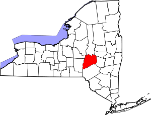 | |
| Towns | ||
| Villages | ||
| CDPs | ||
| Other hamlets | ||
| Footnotes | ‡This populated place also has portions in an adjacent county or counties | |
Coordinates: 42°31′53″N 75°05′17″W / 42.53139°N 75.08806°W