Pittsfield, New York
| Pittsfield, New York | |
|---|---|
| Town | |
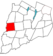 Otsego County map with the Town of Pittsfield in Red | |
| Coordinates: 42°38′N 75°16′W / 42.633°N 75.267°W | |
| Country | United States |
| State | New York |
| County | Otsego |
| Area | |
| • Total | 37.8 sq mi (97.8 km2) |
| • Land | 37.7 sq mi (97.7 km2) |
| • Water | 0.1 sq mi (0.1 km2) |
| Elevation | 1,752 ft (534 m) |
| Population (2010) | |
| • Total | 1,366 |
| • Density | 36/sq mi (14/km2) |
| Time zone | Eastern (EST) (UTC-5) |
| • Summer (DST) | EDT (UTC-4) |
| FIPS code | 36-58343 |
| GNIS feature ID | 0979371 |
Pittsfield is a town in Otsego County, New York, United States. The population was 1,366 at the 2010 census.
The Town of Pittsfield is on the west border of the county, northwest of the City of Oneonta.
History
The town was first settled around 1793.
The Town of Pittsfield was formed from part of the Town of Burlington in 1797. The territory of Pittsfield was reduced two times, in 1806 to form Town of New Lisbon, and in 1859 to form part of the Town of Morris. It was named by the Noble family from Pittsfield, MA, for their old home, who settled in the Pittsfield Centre vicinity.
The hamlet of Pittsfield, or "Pittsfield Centre", had an unmanned whistlestop station and siding on the Ontario & Western RR branch to Edmeston from New Berlin, later purchased by the Unadilla Valley RR. During World War I Richard Freeman and Charles Walton shipped lumber by the carload from here, milled over in Ketchum.
Ketchum takes its name from the Rev. Orvib Ketchum who founded a congregational church on the headwaters of Aldrich Creek in the east part of town, the church was later sold by the Wyoming Conference to the Americana Village near Hamilton, NY. A schoolhouse, store, several steam sawmills and cemetery also existed here. The Ball family operated several "rope walks" nearby, where hemp was wound into twine and then rope.
County Route 13 between Morris and New Berlin is referred to as "the turnpike" by locals, originally constructed in 1832, it was the last section to operate a tollgate due to being the most expensive to build.
Ebenezer Chapel, near the southwest border, was coincidentally named after a nearby resident, and was a small settlement originally known as "Hayti" at one time. In 1956, a nearby house made statewide news when a moonshine still was busted up.
The Beardslee Farm was listed on the National Register of Historic Places in 2000.[1]
Geography
According to the United States Census Bureau, the town has a total area of 37.8 square miles (98 km2), of which, 37.7 square miles (98 km2) of it is land and 0.1 square miles (0.26 km2) of it (0.13%) is water.
The west town line, defined by the Unadilla River, is the border of Chenango County. Wharton Creek flows into the Unadilla River at the west town line. Aldrich Creek drains the east end of town southwards into the Butternut at Elm Grove in Morris.
New York State Route 80 passes through the northwest part of the town.
Demographics
| Historical population | |||
|---|---|---|---|
| Census | Pop. | %± | |
| 1820 | 839 | — | |
| 1830 | 1,005 | 19.8% | |
| 1840 | 1,395 | 38.8% | |
| 1850 | 1,591 | 14.1% | |
| 1860 | 1,480 | −7.0% | |
| 1870 | 1,469 | −0.7% | |
| 1880 | 1,450 | −1.3% | |
| 1890 | 1,218 | −16.0% | |
| 1900 | 1,101 | −9.6% | |
| 1910 | 917 | −16.7% | |
| 1920 | 813 | −11.3% | |
| 1930 | 727 | −10.6% | |
| 1940 | 796 | 9.5% | |
| 1950 | 850 | 6.8% | |
| 1960 | 880 | 3.5% | |
| 1970 | 968 | 10.0% | |
| 1980 | 1,067 | 10.2% | |
| 1990 | 1,116 | 4.6% | |
| 2000 | 1,295 | 16.0% | |
| 2010 | 1,366 | 5.5% | |
| Est. 2014 | 1,334 | [2] | −2.3% |
As of the census[4] of 2000, there were 1,295 people, 474 households, and 359 families residing in the town. The population density was 34.3 people per square mile (13.3/km²). There were 605 housing units at an average density of 16.0 per square mile (6.2/km²). The racial makeup of the town was 98.84% White, 0.23% African American, 0.15% Native American, 0.23% Asian, 0.08% from other races, and 0.46% from two or more races. Hispanic or Latino of any race were 0.69% of the population.
There were 474 households out of which 36.5% had children under the age of 18 living with them, 63.3% were married couples living together, 7.2% had a female householder with no husband present, and 24.1% were non-families. 19.2% of all households were made up of individuals and 9.1% had someone living alone who was 65 years of age or older. The average household size was 2.73 and the average family size was 3.03.
In the town the population was spread out with 27.3% under the age of 18, 5.9% from 18 to 24, 28.3% from 25 to 44, 26.8% from 45 to 64, and 11.7% who were 65 years of age or older. The median age was 38 years. For every 100 females there were 104.6 males. For every 100 females age 18 and over, there were 104.6 males.
The median income for a household in the town was $30,078, and the median income for a family was $36,328. Males had a median income of $27,446 versus $21,912 for females. The per capita income for the town was $15,347. About 13.5% of families and 17.0% of the population were below the poverty line, including 20.9% of those under age 18 and 12.3% of those age 65 or over.
Communities and locations in Pittsfield
- Briggs Corners – A location northwest of Pittsfield village.
- Cardtown – A location northeast of Pittsfield village.
- Finksville – About a mile east of New Berlin on the Turnpike/County 13, once home of a large woodenware and pump log manufactory.
- Hoboken – A hamlet near the west town line on NY-80. Named for workers who migrated up from Hoboken, NJ, at the Bordens Condensory that was originally the Arkwright textile mill and c. 1900 was the largest dairy condensory in the world, just east of the Village of New Berlin and served by a branch of the O&WRR.
- Ketchum – A location in the western part of the town on County Route 49, formerly site of a Congregational church founded by Rev. Orvib Ketchum for whom the hamlet was named.
- Pittsfield – The hamlet of Pittsfield, formerly "Pittsfield Centre", is on NY Route 80 in the northern part of the town.
- Silver Lake – (1) A hamlet near the Unadilla River located north of (2) a small lake of the same name, both located west of County Highway 18.
- Shacktown Mountain – An elevation in the southwest corner of Pittsfield.
- Taylors Corners – A location northeast of Pittsfield village on County Route 49.
References
- ↑ National Park Service (2009-03-13). "National Register Information System". National Register of Historic Places. National Park Service.
- ↑ "Annual Estimates of the Resident Population for Incorporated Places: April 1, 2010 to July 1, 2014". Retrieved June 4, 2015.
- ↑ "Census of Population and Housing". Census.gov. Retrieved June 4, 2015.
- ↑ "American FactFinder". United States Census Bureau. Retrieved 2008-01-31.
External links
Municipalities and communities of Otsego County, New York, United States | ||
|---|---|---|
| City | 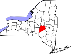 | |
| Towns | ||
| Villages | ||
| CDPs | ||
| Other hamlets | ||
| Footnotes | ‡This populated place also has portions in an adjacent county or counties | |
Coordinates: 42°38′N 75°16′W / 42.633°N 75.267°W