Le Château-d'Oléron
| Le Château-d'Oléron | ||
|---|---|---|
 | ||
| ||
 Le Château-d'Oléron | ||
|
Location within Nouvelle-Aquitaine region  Le Château-d'Oléron | ||
| Coordinates: 45°53′09″N 1°11′41″W / 45.8858°N 1.1947°WCoordinates: 45°53′09″N 1°11′41″W / 45.8858°N 1.1947°W | ||
| Country | France | |
| Region | Nouvelle-Aquitaine | |
| Department | Charente-Maritime | |
| Arrondissement | Rochefort | |
| Canton | Le Château-d'Oléron | |
| Intercommunality | Île-d'Oléron | |
| Government | ||
| • Mayor (2008–2014) | Michel Parent | |
| Area1 | 15.67 km2 (6.05 sq mi) | |
| Population (2008)2 | 3,941 | |
| • Density | 250/km2 (650/sq mi) | |
| Time zone | CET (UTC+1) | |
| • Summer (DST) | CEST (UTC+2) | |
| INSEE/Postal code | 17093 / 17480 | |
| Elevation | 0–10 m (0–33 ft) | |
|
1 French Land Register data, which excludes lakes, ponds, glaciers > 1 km² (0.386 sq mi or 247 acres) and river estuaries. 2 Population without double counting: residents of multiple communes (e.g., students and military personnel) only counted once. | ||
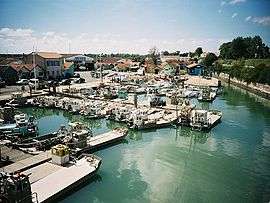
Le Château-d'Oléron is a commune located on the island of Oleron in the Charente-Maritime department in southwestern France.
Population
| Historical population | ||
|---|---|---|
| Year | Pop. | ±% |
| 1793 | 2,251 | — |
| 1800 | 2,558 | +13.6% |
| 1806 | 2,735 | +6.9% |
| 1821 | 2,632 | −3.8% |
| 1831 | 2,527 | −4.0% |
| 1836 | 2,644 | +4.6% |
| 1841 | 2,485 | −6.0% |
| 1846 | 2,542 | +2.3% |
| 1851 | 2,632 | +3.5% |
| 1856 | 3,003 | +14.1% |
| 1861 | 2,920 | −2.8% |
| 1866 | 3,211 | +10.0% |
| 1872 | 3,328 | +3.6% |
| 1876 | 2,850 | −14.4% |
| 1881 | 3,132 | +9.9% |
| 1886 | 3,007 | −4.0% |
| 1891 | 3,458 | +15.0% |
| 1896 | 3,573 | +3.3% |
| 1901 | 3,803 | +6.4% |
| 1906 | 3,334 | −12.3% |
| 1911 | 3,734 | +12.0% |
| 1921 | 3,142 | −15.9% |
| 1926 | 3,018 | −3.9% |
| 1931 | 3,061 | +1.4% |
| 1936 | 3,281 | +7.2% |
| 1946 | 2,864 | −12.7% |
| 1954 | 2,870 | +0.2% |
| 1962 | 3,171 | +10.5% |
| 1968 | 3,254 | +2.6% |
| 1975 | 3,324 | +2.2% |
| 1982 | 3,411 | +2.6% |
| 1990 | 3,544 | +3.9% |
| 1999 | 3,552 | +0.2% |
| 2008 | 3,941 | +11.0% |
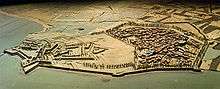 Le Château-d'Oléron, 1703 military mock-up
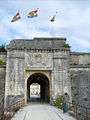 The main gate of the citadel
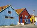 Old oyster farmers' huts renewed and converted into arts and crafts shops
See also
References
| Wikimedia Commons has media related to Le Château-d'Oléron. |
This article is issued from Wikipedia - version of the 2/12/2016. The text is available under the Creative Commons Attribution/Share Alike but additional terms may apply for the media files.