Lexington, Minnesota
| Lexington, Minnesota | |
|---|---|
| City | |
 Location of the city of Lexington within Anoka County, Minnesota | |
| Coordinates: 45°8′15″N 93°10′20″W / 45.13750°N 93.17222°WCoordinates: 45°8′15″N 93°10′20″W / 45.13750°N 93.17222°W | |
| Country | United States |
| State | Minnesota |
| County | Anoka |
| Area[1] | |
| • Total | 0.69 sq mi (1.79 km2) |
| • Land | 0.69 sq mi (1.79 km2) |
| • Water | 0 sq mi (0 km2) |
| Elevation | 909 ft (277 m) |
| Population (2010)[2] | |
| • Total | 2,049 |
| • Estimate (2014) | 2,022 |
| • Density | 2,969.6/sq mi (1,146.6/km2) |
| Time zone | Central (CST) (UTC-6) |
| • Summer (DST) | CDT (UTC-5) |
| ZIP code | 55014 |
| Area code(s) | 763 |
| FIPS code | 27-36836[3] |
| GNIS feature ID | 0646627[4] |
| Website | www.ci.lexington.mn.us |
Lexington is a city in Anoka County, Minnesota, United States, and is a northern suburb of the Twin Cities metropolitan area. The population was 2,049 at the 2010 census.[5]
Geography
According to the United States Census Bureau, the city has a total area of 0.69 square miles (1.79 km2), all of it land.[1]
Lake Drive / County 23 serves as a main route in the community. Other routes include Lexington Avenue and Lovell Road. Interstate 35W is in close proximity to the city.
The city of Lexington borders Blaine, Circle Pines, and Lino Lakes. The landscape in the area is uniformly flat because the city sits entirely on the Anoka Sand Plain.
Public service
The city of Lexington is served by the Centennial Lakes Police Department, the Lexington Fire Department and the Centennial School District.
Demographics
| Historical population | |||
|---|---|---|---|
| Census | Pop. | %± | |
| 1960 | 1,457 | — | |
| 1970 | 2,165 | 48.6% | |
| 1980 | 2,150 | −0.7% | |
| 1990 | 2,279 | 6.0% | |
| 2000 | 2,214 | −2.9% | |
| 2010 | 2,049 | −7.5% | |
| Est. 2015 | 2,022 | [6] | −1.3% |
2010 census
As of the census[2] of 2010, there were 2,049 people, 787 households, and 519 families residing in the city. The population density was 2,969.6 inhabitants per square mile (1,146.6/km2). There were 861 housing units at an average density of 1,247.8 per square mile (481.8/km2). The racial makeup of the city was 87.8% White, 2.7% African American, 1.1% Native American, 3.0% Asian, 0.1% Pacific Islander, 2.6% from other races, and 2.5% from two or more races. Hispanic or Latino of any race were 5.7% of the population.
There were 787 households of which 34.4% had children under the age of 18 living with them, 43.6% were married couples living together, 15.1% had a female householder with no husband present, 7.2% had a male householder with no wife present, and 34.1% were non-families. 25.7% of all households were made up of individuals and 4.3% had someone living alone who was 65 years of age or older. The average household size was 2.60 and the average family size was 3.13.
The median age in the city was 34.6 years. 25.5% of residents were under the age of 18; 9.8% were between the ages of 18 and 24; 28.9% were from 25 to 44; 29.1% were from 45 to 64; and 6.5% were 65 years of age or older. The gender makeup of the city was 52.0% male and 48.0% female.
2000 census
As of the census[3] of 2000, there were 2,214 people, 847 households, and 553 families residing in the city. The population density was 3,196.1 people per square mile (1,238.9/km²). There were 879 housing units at an average density of 1,268.9 per square mile (491.9/km²). The racial makeup of the city was 93.36% White, 1.49% African American, 0.95% Native American, 1.36% Asian, 0.09% Pacific Islander, 0.99% from other races, and 1.76% from two or more races. Hispanic or Latino of any race were 2.53% of the population.
There were 847 households out of which 37.3% had children under the age of 18 living with them, 44.2% were married couples living together, 14.9% had a female householder with no husband present, and 34.6% were non-families. 27.0% of all households were made up of individuals and 5.7% had someone living alone who was 65 years of age or older. The average household size was 2.61 and the average family size was 3.15.
In the city the population was spread out with 29.2% under the age of 18, 9.9% from 18 to 24, 36.9% from 25 to 44, 18.6% from 45 to 64, and 5.5% who were 65 years of age or older. The median age was 32 years. For every 100 females there were 110.5 males. For every 100 females age 18 and over, there were 112.9 males.
The median income for a household in the city was $41,618, and the median income for a family was $48,047. Males had a median income of $35,903 versus $27,147 for females. The per capita income for the city was $18,944. About 9.6% of families and 10.7% of the population were below the poverty line, including 15.0% of those under age 18 and 12.4% of those age 65 or over.
References
- 1 2 "US Gazetteer files 2010". United States Census Bureau. Archived from the original on January 24, 2012. Retrieved 2012-11-13.
- 1 2 "American FactFinder". United States Census Bureau. Retrieved 2012-11-13.
- 1 2 "American FactFinder". United States Census Bureau. Archived from the original on September 11, 2013. Retrieved 2008-01-31.
- ↑ "US Board on Geographic Names". United States Geological Survey. 2007-10-25. Retrieved 2008-01-31.
- ↑ "2010 Census Redistricting Data (Public Law 94-171) Summary File". American FactFinder. U.S. Census Bureau, 2010 Census. Archived from the original on July 21, 2011. Retrieved 23 April 2011.
- ↑ "Annual Estimates of the Resident Population for Incorporated Places: April 1, 2010 to July 1, 2015". Retrieved July 2, 2016.
- ↑ "Census of Population and Housing". Census.gov. Archived from the original on May 11, 2015. Retrieved June 4, 2015.
External links
Municipalities and communities of Anoka County, Minnesota, United States | ||
|---|---|---|
| Cities | 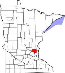 | |
| Township | ||
| CDP | ||
| Unincorporated community | ||
| Ghost town | ||
| Footnotes | ‡This populated place also has portions in an adjacent county or counties | |