Lino Lakes, Minnesota
| Lino Lakes | |
|---|---|
| City | |
| Lino Lakes, Minnesota | |
| Motto: "A Community With A Vision" | |
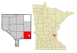 Location of the city of Lino Lakes within Anoka County, Minnesota | |
| Coordinates: 45°10′3″N 93°5′51″W / 45.16750°N 93.09750°W | |
| Country | United States |
| State | Minnesota |
| County | Anoka |
| Government | |
| • Mayor | Jeff Reinert (R) |
| Area[1] | |
| • Total | 33.21 sq mi (86.01 km2) |
| • Land | 28.22 sq mi (73.09 km2) |
| • Water | 4.99 sq mi (12.92 km2) |
| Elevation | 886 ft (270 m) |
| Population (2010)[2] | |
| • Total | 20,216 |
| • Estimate (2015)[3] | 21,050 |
| • Density | 716.4/sq mi (276.6/km2) |
| Time zone | Central (CST) (UTC-6) |
| • Summer (DST) | CDT (UTC-5) |
| ZIP code | 55014/55038 |
| Area code(s) | Area code 651 |
| FIPS code | 27-37322[4] |
| GNIS feature ID | 0659714[5] |
| Website | City of Lino Lakes |
Lino Lakes (/ˈlaɪnoʊ ˈleɪks/ LY-noh LAYKS) is a city in Anoka County, Minnesota, United States. The population was 20,216 at the 2010 census.[6] Interstates 35W and 35E are two of the main routes in the community. It is an outer suburb north of the Twin Cities.
Geography
According to the United States Census Bureau, the city has a total area of 33.21 square miles (86.01 km2), of which, 28.22 square miles (73.09 km2) is land and 4.99 square miles (12.92 km2) is water.[1] Only 44% of the land within the city was developed in 2010 compared to 37% in 2000.
Rice Creek flows through the city.[7] Rice Creek Chain of Lakes Regional Park Reserve is located within Lino Lakes.
Lino Lakes' main shopping area is the Town Center at the intersection of Interstate 35W and County 23–Lake Drive. It includes a SuperTarget and Kohl's, a YMCA, civic complex and other office, medical and retail.
Nearby places include Forest Lake, Hugo, White Bear Township, Shoreview, Circle Pines, Lexington, Blaine, Ham Lake, and Columbus. The city of Centerville is an enclave within Lino Lakes—that is, entirely surrounded on all borders by Lino Lakes.
Demographics
| Historical population | |||
|---|---|---|---|
| Census | Pop. | %± | |
| 1960 | 2,329 | — | |
| 1970 | 3,692 | 58.5% | |
| 1980 | 4,966 | 34.5% | |
| 1990 | 7,807 | 57.2% | |
| 2000 | 11,791 | 51.0% | |
| 2010 | 20,216 | 71.5% | |
| Est. 2015 | 21,050 | [8] | 4.1% |
| U.S. Decennial Census[9] 2015 Estimate[3] | |||
2010 census
As of the census[2] of 2010, there were 20,216 people, 4,174 households, and 3,683 families residing in the city. The population density was 516.4 inhabitants per square mile (199.4/km2). There were 5,323 housing units at an average density of 214.1 per square mile (82.7/km2). The racial makeup of the city was 94.14% White, 1.1% African American, 2.03% Native American, 2.6% Asian, 0.1% Pacific Islander, 0.3% from other races, and 0.6% from two or more races. Hispanic or Latino of any race were 2.7% of the population.
There were 6,174 households of which 48.1% had children under the age of 18 living with them, 73.2% were married couples living together, 7.2% had a female householder with no husband present, 3.5% had a male householder with no wife present, and 16.1% were non-families. 12.0% of all households were made up of individuals and 2.4% had someone living alone who was 65 years of age or older. The average household size was 3.05 and the average family size was 3.37.
The median age in the city was 37.44 years. 28.8% of residents were under the age of 18; 7.8% were between the ages of 18 and 24; 27.1% were from 25 to 44; 31.6% were from 45 to 64; and 4.8% were 65 years of age or older. The gender makeup of the city was 53.8% male and 46.2% female.
2000 census
As of the census[4] of 2000, there were 11,791 people, 3,857 households, and 3,162 families residing in the city. The population density was 475.1 people per square mile (229.7/km²). There were 4,021 housing units at an average density of 174.4 per square mile (67.3/km²). The racial makeup of the city was 95.56% White, 0.9% African American, 1.0% Native American, 1.4% Asian, 0.01% Pacific Islander, 0.68% from other races, and 1.22% from two or more races. Hispanic or Latino of any race were 1.54% of the population.
There were 3,857 households out of which 55.9% had children under the age of 18 living with them, 77.6% were married couples living together, 5.0% had a female householder with no husband present, and 14.3% were non-families. 10.0% of all households were made up of individuals and 2.1% had someone living alone who was 65 years of age or older. The average household size was 3.20 and the average family size was 3.44.
In the city the population was spread out with 33.7% under the age of 18, 6.6% from 18 to 24, 39.8% from 25 to 44, 16.7% from 45 to 64, and 3.3% who were 65 years of age or older. The median age was 33 years. For every 100 females there were 118.3 males. For every 100 females age 18 and over, there were 124.8 males.
The median income for a household in the city was $75,708, and the median income for a family was $79,183. Males had a median income of $56,088 versus $37,220 for females. The per capita income for the city was $25,419. About 1.1% of families and 2.0% of the population were below the poverty line, including 2.6% of those under age 18 and 1.4% of those age 65 or over.
History
Settlement
When the first settlers arrived, Native Americans were already making their home in the area where Reshanau, Baldwin, Rice and Marshan Lakes cluster. The Dakota Indians found this to be a land of plenty with an abundance of wild rice and small game. Today, several Indian burial grounds are located in the area. White hunters and trappers began coming to this area from both Canada and the eastern states around 1850. Those who settled on the west side of the lake had names like Ramsden, Speiserand Wenzel. The east side of the lake was settled by families including the Cardinals, LaMottes, Houles and Dupres. Many of their descendants still live in the area today. The first unit of local government in the area was the township of Centerville, organized August 11, 1857, encompassing an area of 36 square miles. The population of just under 300 people was organized into three loosely knit communities known as the "German settlement" west of the lakes, the "Swede settlement" south of the lakes, and the "French settlement" east of the lakes. In the 1950s neighboring villages started annexing land away from Centerville Township. To protect the boundaries and allow for the financing of public improvements, the residents of the township voted to incorporate into a village.[10]
Naming
Several names were suggested for the new village, and most contained the word "lakes". Although the origin of the word "Lino" is unknown, a Lino post office operated for about 10 years in the late 1800s. The town board decided to name the new village "Lino Lakes". On May 11, 1955, the Village of Lino Lakes was incorporated. It covered the original Centerville Township, with the exception of the Village of Centerville, and comprised 21,000 acres of land and 1,800 citizens. In 1972, the State Legislature passed a law changing all Minnesota villages to cities, hence Lino Lakes' current status.[10]
Education
A majority of the city is served by the Centennial School District which was ranked as having better public schools than 90% of the country, and 95% of the rest of the state in 2011.[11] Lino Lakes Elementary is also located within the city, but falls within the adjacent Forest Lake School District.
| Centennial District Schools | ||
| Blue Heron Elementary (Lino Lakes) | Centennial Elementary (Centerville) | |
| Centennial Adult Continuing Education (Circle Pines) | Centennial High School (Blaine) | |
| Centennial Area Learning Center (Circle Pines) | Centennial Middle School (Lino Lakes) | |
| Centennial Early Childhood Center (Lino Lakes) | Golden Lake Elementary (Circle Pines) | |
| Centennial Elementary (Blaine) | Rice Lake Elementary (Lino Lakes) | |
Places of worship
- St. Joseph of the Lakes (Catholic)
- North Springs Church (Assembly of God)
- Living Waters Lutheran Church (Lutheran)
- Eagle Brook Church (Baptist)
- Rice Creek Covenant Church (Covenant)
- Russian Baptist Church (Russian Baptist)
- Gethsemane United Methodist (Methodist)
- Christo's Center for Spiritual Formation (Ecumenical)
Recreation
Parks
The Lakes Parks and Recreation Department is responsible for the development and maintenance of the parks and trails system. Development of the parks system includes installing playground equipment, and benches, irrigation, landscaping projects. Staff maintains 11 softball/baseball fields, 12 soccer fields and 3 ice rinks as well as approximately 30 miles of trails. The 5,500-acre Rice Creek Chain of Lakes Regional Park Reserve is located in Lino Lakes and is one of the largest parks in the seven-county metropolitan area and contains some of the most significant native wildlife habitat and water resources in the regional area.
| Lino Lakes Parks | ||
| Arena Acres Park | Clearwater Creek Park | Rice Creek Regional Park |
| Behm's Park | Country Lakes Park | Shenandoah Park |
| Birch Park | Highland Meadow's Park | Sunrise Park |
| Birchwood Acres Park | Lino Park | Sunset Oaks Park |
| Brandywood Park | Marshan Park | Wenzel Farms Park |
| City Hall Park | Pheasant Hills Park | Woods of Baldwin Lake |
Golf
There are 2 golf facilities in Lino Lakes, Chomonix Golf Course and Shadow Ridge Driving Range.
Controversies
English Only Resolution
On July 26, 2010, the Lino Lakes City Council voted 4–1 in favor of establishing English as the official language in Lino Lakes. The resolution was voted on to avoid unnecessary expense and simply stated that all official documents would be prepared in English and that the city would not pay for any translation of its official documents into any other language. Costs for a government entity to officially translate documents is very time consuming and expensive. Many cities needlessly spend tax payer dollars translating their official documents into other languages when citizens can simply do the translations themselves on the internet in just a few minutes.
Some people misunderstood the intent of the resolution and called it a controversial English-only resolution for the city, the first city in Minnesota to approve such a measure as part of the English-only movement.[12] The resolution would bar use of city money for translation of city documents into languages other than English. The Metro North Chamber of Commerce president Lori Higgens stated "it makes the area appear unwelcoming."[13]
References
- 1 2 "US Gazetteer files 2010". United States Census Bureau. Retrieved 2012-11-13.
- 1 2 "American FactFinder". United States Census Bureau. Retrieved 2012-11-13.
- 1 2 "Population Estimates". United States Census Bureau. Retrieved June 13, 2016.
- 1 2 "American FactFinder". United States Census Bureau. Retrieved 2008-01-31.
- ↑ "US Board on Geographic Names". United States Geological Survey. 2007-10-25. Retrieved 2008-01-31.
- ↑ "2010 Census Redistricting Data (Public Law 94-171) Summary File". American FactFinder. U.S. Census Bureau, 2010 Census. Retrieved 23 April 2011.
- ↑ King's Twin Cities Metro Street Atlas '04. Minneapolis: The Lawrence Group. 2004. ISBN 1-58301-215-X.
- ↑ "Annual Estimates of the Resident Population for Incorporated Places: April 1, 2010 to July 1, 2015". Retrieved July 2, 2016.
- ↑ United States Census Bureau. "Census of Population and Housing". Retrieved October 28, 2014.
- 1 2 "Resident's Guide", City of Lino Lakes, March 2014
- ↑ http://www.cnbc.com/id/44347217/page/9
- ↑ "Lino Lakes approves English-only resolution", Minneapolis Star Tribune, July 27, 2010.
- ↑ "Lino Lakes OKs English-only ordinance", Minneapolis Star Tribune, July 26, 2010 ,
External links
Municipalities and communities of Anoka County, Minnesota, United States | ||
|---|---|---|
| Cities |  | |
| Township | ||
| CDP | ||
| Unincorporated community | ||
| Ghost town | ||
| Footnotes | ‡This populated place also has portions in an adjacent county or counties | |
Coordinates: 45°09′37″N 93°05′20″W / 45.16028°N 93.08889°W