Liberty County, Montana
| Liberty County, Montana | |
|---|---|
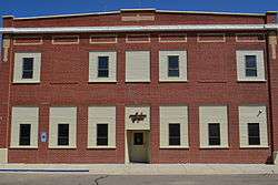 Liberty County Courthouse in Chester | |
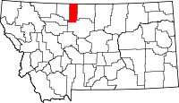 Location in the U.S. state of Montana | |
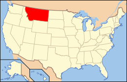 Montana's location in the U.S. | |
| Founded | February 11, 1920[1] |
| Seat | Chester |
| Largest town | Chester |
| Area | |
| • Total | 1,447 sq mi (3,748 km2) |
| • Land | 1,430 sq mi (3,704 km2) |
| • Water | 17 sq mi (44 km2), 1.2% |
| Population (est.) | |
| • (2015) | 2,408 |
| • Density | 1.6/sq mi (1/km²) |
| Congressional district | At-large |
| Time zone | Mountain: UTC-7/-6 |
| Website |
www |
Liberty County is a county located in the U.S. state of Montana. As of the 2010 census, the population was 2,339.[2] Its county seat is Chester.[3] The county was established in 1919.[4]
Liberty County is home to Tiber Dam, which is located in the south western part of the county. It is south of the Canada–US border with Alberta.
Geography
According to the U.S. Census Bureau, the county has a total area of 1,447 square miles (3,750 km2), of which 1,430 square miles (3,700 km2) is land and 17 square miles (44 km2) (1.2%) is water.[5]
Adjacent counties
- Toole County, Montana – west
- Pondera County, Montana – southwest
- Chouteau County, Montana – south
- Hill County, Montana – east
- County of Forty Mile No. 8, Alberta – north
Demographics
| Historical population | |||
|---|---|---|---|
| Census | Pop. | %± | |
| 1920 | 2,416 | — | |
| 1930 | 2,198 | −9.0% | |
| 1940 | 2,209 | 0.5% | |
| 1950 | 2,180 | −1.3% | |
| 1960 | 2,624 | 20.4% | |
| 1970 | 2,359 | −10.1% | |
| 1980 | 2,329 | −1.3% | |
| 1990 | 2,295 | −1.5% | |
| 2000 | 2,158 | −6.0% | |
| 2010 | 2,339 | 8.4% | |
| Est. 2015 | 2,408 | [6] | 2.9% |
| U.S. Decennial Census[7] 1790–1960[8] 1900–1990[9] 1990–2000[10] 2010–2015[2] | |||
2000 census
As of the census[11] of 2000, there were 2,158 people, 833 households, and 583 families residing in the county. The population density was 2 people per square mile (1/km²). There were 1,070 housing units at an average density of 1 per square mile (0/km²). The racial makeup of the county was 99.21% White, 0.09% Native American, 0.32% Asian, 0.09% from other races, and 0.28% from two or more races. 0.19% of the population were Hispanic or Latino of any race. 39.0% were of German, 20.0% Norwegian, 7.2% English, 5.8% American and 5.0% Irish ancestry. 84.5% spoke English and 15.5% German as their first language.
There were 833 households out of which 30.40% had children under the age of 18 living with them, 62.70% were married couples living together, 5.60% had a female householder with no husband present, and 29.90% were non-families. 27.90% of all households were made up of individuals and 14.00% had someone living alone who was 65 years of age or older. The average household size was 2.51 and the average family size was 3.11.
In the county the population was spread out with 25.80% under the age of 18, 5.80% from 18 to 24, 24.70% from 25 to 44, 24.10% from 45 to 64, and 19.70% who were 65 years of age or older. The median age was 42 years. For every 100 females there were 97.10 males. For every 100 females age 18 and over, there were 93.60 males.
The median income for a household in the county was $30,284, and the median income for a family was $37,361. Males had a median income of $23,158 versus $16,579 for females. The per capita income for the county was $14,882. About 19.00% of families and 20.30% of the population were below the poverty line, including 28.90% of those under age 18 and 15.50% of those age 65 or over.
Researchers William P. O'Hare and Kenneth M. Johnson described the county as typical of the northern Great Plains in being very thinly settled, almost fully dependent on agriculture, and lacking in urban areas. They noted that income can fluctuate substantially from year to year, depending on rainfall (which affects harvest yields) as well as grain and cattle prices, and that the 2000 Census recorded low incomes in 1999 after several years of drought. Also, the presence of Hutterite colonies in the county depresses per capita incomes because Hutterite families have significantly more children than the general population.[12]
2010 census
As of the 2010 United States Census, there were 2,339 people, 822 households, and 537 families residing in the county.[13] The population density was 1.6 inhabitants per square mile (0.62/km2). There were 1,043 housing units at an average density of 0.7 per square mile (0.27/km2).[14] The racial makeup of the county was 98.2% white, 0.2% American Indian, 0.1% black or African American, 0.1% Asian, 0.2% from other races, and 1.2% from two or more races. Those of Hispanic or Latino origin made up 0.3% of the population.[13] In terms of ancestry, 55.4% were German, 24.1% were Norwegian, 14.5% were Irish, 9.9% were English, and 1.4% were American.[15]
Of the 822 households, 23.7% had children under the age of 18 living with them, 59.5% were married couples living together, 4.7% had a female householder with no husband present, 34.7% were non-families, and 32.2% of all households were made up of individuals. The average household size was 2.36 and the average family size was 3.00. The median age was 44.6 years.[13]
The median income for a household in the county was $40,212 and the median income for a family was $44,957. Males had a median income of $35,788 versus $30,714 for females. The per capita income for the county was $19,097. About 12.4% of families and 19.5% of the population were below the poverty line, including 31.6% of those under age 18 and 15.6% of those age 65 or over.[16]
Communities
Town
- Chester (county seat)
Census-designated place
Unincorporated communities
See also
- List of cemeteries in Liberty County, Montana
- List of lakes in Liberty County, Montana
- List of mountains in Liberty County, Montana
- National Register of Historic Places listings in Liberty County, Montana
References
- ↑ http://genealogytrails.com/mon/countytimeline.html
- 1 2 "State & County QuickFacts". United States Census Bureau. Retrieved September 15, 2013.
- ↑ "Find a County". National Association of Counties. Archived from the original on May 31, 2011. Retrieved 2011-06-07.
- ↑ "History". Liberty County. Retrieved November 30, 2014.
- ↑ "2010 Census Gazetteer Files". United States Census Bureau. August 22, 2012. Retrieved November 28, 2014.
- ↑ "County Totals Dataset: Population, Population Change and Estimated Components of Population Change: April 1, 2010 to July 1, 2015". Retrieved July 2, 2016.
- ↑ "U.S. Decennial Census". United States Census Bureau. Archived from the original on May 11, 2015. Retrieved November 28, 2014.
- ↑ "Historical Census Browser". University of Virginia Library. Retrieved November 28, 2014.
- ↑ "Population of Counties by Decennial Census: 1900 to 1990". United States Census Bureau. Retrieved November 28, 2014.
- ↑ "Census 2000 PHC-T-4. Ranking Tables for Counties: 1990 and 2000" (PDF). United States Census Bureau. Retrieved November 28, 2014.
- ↑ "American FactFinder". United States Census Bureau. Archived from the original on September 11, 2013. Retrieved 2008-01-31.
- ↑ Facing Child Poverty in Rural America by William P. O'Hare and Kenneth M. Johnson, Population Reference Bureau, January 2004
- 1 2 3 "DP-1 Profile of General Population and Housing Characteristics: 2010 Demographic Profile Data". United States Census Bureau. Retrieved 2016-01-10.
- ↑ "Population, Housing Units, Area, and Density: 2010 – County". United States Census Bureau. Retrieved 2016-01-10.
- ↑ "DP02 SELECTED SOCIAL CHARACTERISTICS IN THE UNITED STATES – 2006–2010 American Community Survey 5-Year Estimates". United States Census Bureau. Retrieved 2016-01-10.
- ↑ "DP03 SELECTED ECONOMIC CHARACTERISTICS – 2006–2010 American Community Survey 5-Year Estimates". United States Census Bureau. Retrieved 2016-01-10.
 |
Forty Mile County No. 8, Alberta, Canada | | ||
| Toole County | |
Hill County | ||
| ||||
| | ||||
| Pondera County | Chouteau County |
Municipalities and communities of Liberty County, Montana, United States | ||
|---|---|---|
| Town | | |
| CDP | ||
| Unincorporated communities | ||
Coordinates: 48°33′N 111°02′W / 48.55°N 111.03°W