List of villages in Alberta
A village is an urban municipality status type used in the Canadian province of Alberta. Alberta villages are created when communities with populations of at least 300 people, where a majority of their buildings are on parcels of land smaller than 1,850 m², apply to Alberta Municipal Affairs for village status under the authority of the Municipal Government Act.[1] Applications for village status are approved via orders in council made by the Lieutenant Governor in Council under recommendation from the Minister of Municipal Affairs.[1]
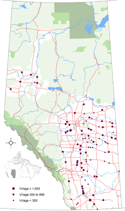
As of 2016, Alberta had 90 villages that had a cumulative population of 38,223 and an average population of 425 in the 2011 Census.[2][3][4][5][6][7] This amount was reduced from 92 on January 1, 2016 when both Galahad and Strome dissolved and become hamlets under the jurisdiction of Flagstaff County.[6][7] Alberta's largest and smallest villages are Stirling and Gadsby with populations of 1,090 and 25 respectively.[2]
When a village's population reaches or exceeds 1,000 people, the council may request a change to town status, but the change in incorporated status is not mandatory.[8] Villages with populations less than 300, whether their populations have declined below 300 or they were incorporated as villages prior to the minimum 300 population requirement, are permitted to retain village status.
Village governance is delivered by 372 elected village officials (90 mayors and 282 councillors) throughout the province.[9]
The highest frequencies of villages in Alberta are found along existing and former rail lines in the east central portion of the province.
Administration
Pursuant to Part 5, Division 1 of the Municipal Government Act (MGA), each municipality created under the authority of the MGA is governed by a council. As a requirement of the MGA, a village council consists of three councillors by default, one of which is the village's chief elected official (CEO) or mayor. A village council may consist of a higher odd number if council passes a bylaw altering its size.[1] For the 2013-2017 term, 39 villages have a council of three, and 51 have a council of five.[9]
Village councils are governed by a mayor and an even number of councillors that are elected by popular vote, resulting in a total odd number of councillors to avoid tie votes on council matters.[1] All council members are elected under the provisions of the Local Authorities Election Act (LAEA).[10] Mayoral or councillor candidates are required to be residents of their municipality for a minimum of six consecutive months prior to nomination day. The last municipal election was October 21, 2013.
Alberta Municipal Affairs, a ministry of the Cabinet of Alberta, is charged with coordination of all levels of local government.
Administrative duties of villages include public safety, local transit, roads, water service, drainage and waste collection, as well as coordination of infrastructure with provincial and regional authorities (including road construction, education, and health).
|


List
| Municipal census population (year)[11] | Population (2011)[2] | Population (2006)[2] | Change (%)[2] | Land area (km²)[2] | Population density (per km²)[2] | |||
|---|---|---|---|---|---|---|---|---|
| Acme | Kneehill County | July 7, 1910 | align=center| 653 | 656 | −0.5 | 2.47 | 263.9 | |
| Alberta Beach | Lac Ste. Anne County | January 1, 1999 | align=center| 865 | 884 | −2.1 | 1.98 | 436.7 | |
| Alix | Lacombe County | June 3, 1907 | align=center| 830 | 851 | −2.5 | 3.15 | 263.4 | |
| Alliance | Flagstaff County | August 26, 1918 | align=center| 174 | 158 | 10.1 | 0.64 | 270.1 | |
| Amisk | Provost No. 52, M.D. of | January 1, 1956 | align=center| 207 | 172 | 20.3 | 0.76 | 272.2 | |
| Andrew | Lamont County | June 24, 1930 | align=center| 379 | 465 | −18.5 | 1.23 | 308.7 | |
| Arrowwood | Vulcan County | May 13, 1926 | align=center| 188 | 221 | −14.9 | 0.66 | 286.1 | |
| Barnwell | Taber, M.D. of | January 1, 1980 | 960 (2015) | align=center| 771 | 618 | 24.8 | 1.49 | 517.2 |
| Barons | Lethbridge County | May 6, 1910 | 318 (2014) | align=center| 315 | 276 | 14.1 | 0.68 | 462.2 |
| Bawlf | Camrose County | October 12, 1906 | align=center| 403 | 367 | 9.8 | 0.96 | 418.5 | |
| Beiseker | Rocky View County | February 23, 1921 | align=center| 785 | 804 | −2.4 | 2.84 | 276.8 | |
| Berwyn | Peace No. 135, M.D. of | November 28, 1936 | align=center| 526 | 516 | 1.9 | 1.66 | 316.7 | |
| Big Valley | Stettler No. 6, County of | March 9, 1942 | 347 (2015) | align=center| 364 | 351 | 3.7 | 1.84 | 198.3 |
| Bittern Lake[N 1] | Camrose County | November 2, 1904 | align=center| 224 | 225 | −0.4 | 6.64 | 33.7 | |
| Botha | Stettler No. 6, County of | September 5, 1911 | align=center| 175 | 185 | −5.4 | 1.09 | 160.7 | |
| Boyle | Athabasca County | December 31, 1953 | 948 (2014) | align=center| 916 | 854 | 7.3 | 7.28 | 125.8 |
| Breton | Brazeau County | January 1, 1957 | 581 (2012) | align=center| 496 | 550 | −9.8 | 1.73 | 286.5 |
| Carbon | Kneehill County | November 18, 1912 | align=center| 592 | 570 | 3.9 | 2.00 | 295.6 | |
| Carmangay | Vulcan County | March 4, 1936 | 262 (2013) | align=center| 367 | 336 | 9.2 | 1.86 | 197.1 |
| Caroline | Clearwater County | December 31, 1951 | align=center| 501 | 515 | −2.7 | 1.98 | 252.8 | |
| Cereal | Special Area No. 3 | August 19, 1914 | align=center| 134 | 126 | 6.3 | 0.95 | 141.6 | |
| Champion | Vulcan County | May 27, 1911 | align=center| 378 | 364 | 3.8 | 0.88 | 429.7 | |
| Chauvin | Wainwright No. 61, M.D. of | December 30, 1912 | 340 (2011) | align=center| 334 | 308 | 8.4 | 2.32 | 143.9 |
| Chipman | Lamont County | October 21, 1913 | align=center| 284 | 253 | 12.3 | 9.61 | 29.5 | |
| Clive | Lacombe County | January 9, 1912 | align=center| 675 | 562 | 20.1 | 2.12 | 318.3 | |
| Clyde | Westlock County | January 28, 1914 | align=center| 503 | 470 | 7.0 | 1.36 | 370.7 | |
| Consort | Special Area No. 4 | September 23, 1912 | 722 (2012) | align=center| 689 | 739 | −6.8 | 2.83 | 243.3 |
| Coutts | Warner No. 5, County of | January 1, 1960 | align=center| 277 | 305 | −9.2 | 0.98 | 283.3 | |
| Cowley | Pincher Creek No. 9, M.D. of | August 16, 1906 | align=center| 236 | 219 | 7.8 | 1.40 | 168.8 | |
| Cremona | Mountain View County | January 1, 1955 | align=center| 457 | 463 | −1.3 | 1.71 | 267.8 | |
| Czar | Provost No. 52, M.D. of | November 12, 1917 | align=center| 167 | 175 | −4.6 | 1.18 | 141.6 | |
| Delburne | Red Deer County | January 17, 1913 | align=center| 830 | 765 | 8.5 | 3.92 | 211.5 | |
| Delia[N 2] | Starland County | July 20, 1914 | align=center| 186 | 207 | −10.1 | 1.31 | 142.5 | |
| Dewberry | Vermilion River, County of | January 1, 1957 | align=center| 201 | 196 | 2.6 | 0.84 | 238.5 | |
| Donalda | Stettler No. 6, County of | December 30, 1912 | align=center| 259 | 224 | 15.6 | 0.99 | 262.3 | |
| Donnelly | Smoky River No. 130, M.D. of | January 1, 1956 | align=center| 305 | 293 | 4.1 | 1.27 | 239.9 | |
| Duchess | Newell, County of | May 12, 1921 | align=center| 992 | 978 | 1.4 | 1.89 | 526.2 | |
| Edberg | Camrose County | February 4, 1930 | align=center| 168 | 155 | 8.4 | 0.36 | 470.9 | |
| Edgerton | Wainwright No. 61, M.D. of | September 11, 1917 | 401 (2012) | align=center| 317 | 373 | −15.0 | 1.89 | 168.1 |
| Elnora | Red Deer County | July 22, 1929 | 320 (2011) | align=center| 313 | 280 | 11.8 | 1.48 | 210.9 |
| Empress | Special Area No. 2 | February 5, 1914 | align=center| 188 | 136 | 38.2 | 1.75 | 107.6 | |
| Ferintosh | Camrose County | January 9, 1911 | align=center| 181 | 153 | 18.3 | 0.62 | 290.2 | |
| Foremost | Forty Mile No. 8, County of | December 31, 1950 | align=center| 526 | 524 | 0.4 | 1.89 | 277.8 | |
| Forestburg | Flagstaff County | August 21, 1919 | 880 (2014) | align=center| 831 | 895 | −7.2 | 2.75 | 302.0 |
| Gadsby | Stettler No. 6, County of | May 6, 1910 | align=center| 25 | 35 | −28.6 | 0.82 | 30.5 | |
| Girouxville | Smoky River No. 130, M.D. of | December 31, 1951 | align=center| 266 | 282 | −5.7 | 0.58 | 461.2 | |
| Glendon | Bonnyville No. 87, M.D. of | January 1, 1956 | align=center| 486 | 421 | 15.4 | 1.98 | 245.1 | |
| Glenwood | Cardston County | January 1, 1961 | align=center| 287 | 280 | 2.5 | 1.46 | 197.2 | |
| Halkirk | Paintearth No. 18, County of | February 10, 1912 | align=center| 121 | 113 | 7.1 | 0.65 | 185.7 | |
| Hay Lakes[N 3] | Camrose County | April 17, 1928 | 492 (2015) | align=center| 425 | 362 | 17.4 | 0.58 | 730.1 |
| Heisler | Flagstaff County | January 1, 1961 | align=center| 151 | 153 | −1.3 | 0.76 | 199.9 | |
| Hill Spring | Cardston County | January 1, 1961 | align=center| 186 | 192 | −3.1 | 1.11 | 167.2 | |
| Hines Creek | Clear Hills County | December 31, 1951 | align=center| 380 | 430 | −11.6 | 4.37 | 86.9 | |
| Holden | Beaver County | April 14, 1909 | align=center| 381 | 398 | −4.3 | 1.70 | 224.3 | |
| Hughenden | Provost No. 52, M.D. of | December 27, 1917 | 258 (2012) | align=center| 230 | 231 | −0.4 | 0.78 | 296.6 |
| Hussar | Wheatland County | April 20, 1928 | align=center| 176 | 187 | −5.9 | 0.99 | 177.8 | |
| Hythe | Grande Prairie No. 1, County of | August 31, 1929 | align=center| 820 | 821 | −0.1 | 4.12 | 198.8 | |
| Innisfree | Minburn No. 27, County of | March 11, 1911 | align=center| 220 | 233 | −5.6 | 1.27 | 172.6 | |
| Irma | Wainwright No. 61, M.D. of | May 30, 1912 | align=center| 457 | 444 | 2.9 | 1.11 | 410.7 | |
| Kitscoty | Vermilion River, County of | March 22, 1911 | 967 (2013) | align=center| 846 | 709 | 19.3 | 1.54 | 549.8 |
| Linden | Kneehill County | January 1, 1964 | align=center| 725 | 660 | 9.8 | 2.56 | 283.3 | |
| Lomond | Vulcan County | February 16, 1916 | align=center| 173 | 175 | −1.1 | 1.28 | 134.9 | |
| Longview | Foothills No. 31, M.D. of | January 1, 1964 | align=center| 307 | 300 | 2.3 | 1.09 | 282.1 | |
| Lougheed | Flagstaff County | November 7, 1911 | 273 (2013) | align=center| 233 | 217 | 7.4 | 1.92 | 121.5 |
| Mannville | Minburn No. 27, County of | December 29, 1906 | align=center| 803 | 782 | 2.7 | 2.15 | 373.6 | |
| Marwayne | Vermilion River, County of | December 31, 1952 | 667 (2013) | align=center| 612 | 521 | 17.5 | 1.68 | 364.5 |
| Milo | Vulcan County | May 7, 1931 | align=center| 122 | 100 | 22.0 | 1.04 | 116.9 | |
| Morrin | Starland County | April 16, 1920 | align=center| 245 | 253 | −3.2 | 0.82 | 298.9 | |
| Munson | Starland County | May 5, 1911 | align=center| 204 | 217 | −6.0 | 2.60 | 78.5 | |
| Myrnam | Two Hills No. 21, County of | August 22, 1930 | align=center| 370 | 362 | 2.2 | 2.76 | 134.2 | |
| Nampa | Northern Sunrise County | January 1, 1958 | align=center| 362 | 360 | 0.6 | 1.86 | 194.9 | |
| Nobleford | Lethbridge County | February 28, 1918 | align=center| 1,000 | 689 | 45.1 | 1.54 | 647.8 | |
| Paradise Valley | Vermilion River, County of | January 1, 1964 | align=center| 174 | 183 | −4.9 | 0.57 | 306.9 | |
| Rockyford | Wheatland County | March 28, 1919 | align=center| 325 | 349 | −6.9 | 1.08 | 300.0 | |
| Rosalind | Camrose County | January 1, 1966 | align=center| 190 | 190 | 0.0 | 0.59 | 322.2 | |
| Rosemary | Newell, County of | December 31, 1951 | 421 (2012) | align=center| 342 | 388 | −11.9 | 0.56 | 607.8 |
| Rycroft | Spirit River No. 133, M.D. of | March 15, 1944 | align=center| 628 | 638 | −1.6 | 1.69 | 372.5 | |
| Ryley[N 4] | Beaver County | April 2, 1910 | align=center| 497 | 458 | 8.5 | 1.97 | 251.9 | |
| Spring Lake[N 5] | Parkland County | January 1, 1999 | 614 (2012) | align=center| 533 | 501 | 6.4 | 2.12 | 251.5 |
| Standard | Wheatland County | April 29, 1922 | align=center| 379 | 380 | −0.3 | 2.34 | 162.1 | |
| Stirling[N 6] | Warner No. 5, County of | September 3, 1901 | 1,215 (2015) | align=center| 1,090 | 921 | 18.3 | 2.64 | 413.6 |
| Thorsby | Leduc County | December 31, 1949 | 1,025 (2015) | align=center| 951[16] | 945 | 0.6 | 3.87 | 245.7 |
| Veteran | Special Area No. 4 | June 30, 1914 | align=center| 249 | 293 | −15.0 | 0.84 | 297.0 | |
| Vilna | Smoky Lake County | June 23, 1923 | 290 (2012) | align=center| 249 | 274 | −9.1 | 0.90 | 277.5 |
| Wabamun | Parkland County | January 1, 1980 | align=center| 661 | 601 | 10.0 | 3.24 | 203.8 | |
| Warburg | Leduc County | December 31, 1953 | align=center| 789 | 621 | 27.1 | 2.70 | 292.6 | |
| Warner | Warner No. 5, County of | November 12, 1908 | 392 (2011) | align=center| 331 | 307 | 7.8 | 1.15 | 288.5 |
| Waskatenau | Smoky Lake County | May 19, 1932 | align=center| 255 | 278 | −8.3 | 0.60 | 427.6 | |
| Willingdon | Two Hills No. 21, County of | August 31, 1928 | align=center| 275 | 295 | −6.8 | 0.97 | 283.8 | |
| Youngstown | Special Area No. 3 | December 31, 1936 | align=center| 178 | 170 | 4.7 | 1.00 | 177.7 | |
| Total villages | – | – | – | 38,223 | 36,837 | 3.8 | 163.87 | 233.3 |
Notes:
- ↑ Bittern Lake was formerly known as Rosenroll prior to December 16, 1911.[12]
- ↑ Delia was formerly known as Highland prior to December 9, 1915.[13]
- ↑ Hay Lakes was formerly known as Hay Lake prior to January 1, 1932.
- ↑ Ryley was also known as Equity in 1909.[14]
- ↑ Spring Lake was formerly known as Edmonton Beach prior to January 1, 1999.[15]
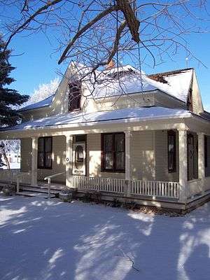
- ↑ Stirling is designated a national historic site.
Village status eligibility
Numerous Alberta hamlets meet the minimum population requirement for village status eligibility.
Town status eligibility
The villages of Stirling, Thorsby and Nobleford are currently eligible for town status having populations of 1,090, 1,025 and 1,000 respectively,[2][17] of which Thorsby is in the final consultation phase before deciding to formally apply for town status.[18]
See also
- List of census divisions of Alberta
- List of cities in Alberta
- List of communities in Alberta
- List of hamlets in Alberta
- List of mayors in Alberta
- List of municipal districts in Alberta
- List of municipalities in Alberta
- List of summer villages in Alberta
- List of towns in Alberta
References
- 1 2 3 4 "Municipal Government Act". Alberta Queen's Printer. Retrieved March 21, 2010.
- 1 2 3 4 5 6 7 8 "Population and dwelling counts, for Canada, provinces and territories, and census subdivisions (municipalities), 2011 and 2006 censuses (Alberta)". Statistics Canada. August 9, 2016. Retrieved November 5, 2016.
- ↑ "Order in Council (O.C.) 328/2012". Province of Alberta. October 17, 2012. Retrieved October 17, 2012.
- ↑ "O.C. 250/2013". Alberta Queen's Printer. August 13, 2013. Retrieved August 18, 2013.
- ↑ "O.C. 152/2015". Government of Alberta. June 24, 2015. Retrieved June 30, 2015.
- 1 2 "O.C. 259/2015". Government of Alberta. November 17, 2015. Retrieved November 19, 2015.
- 1 2 "O.C. 260/2015". Government of Alberta. November 17, 2015. Retrieved November 19, 2015.
- ↑ "Types of Municipalities in Alberta". Alberta Municipal Affairs. Retrieved March 21, 2010.
- 1 2 "Municipal Profiles (Villages)" (PDF). Alberta Municipal Affairs. Retrieved January 19, 2014.
- ↑ "Local Authorities Election Act". Alberta Queen's Printer. Retrieved March 21, 2010.
- ↑ 2015 Municipal Affairs Population List (PDF). Alberta Municipal Affairs. ISBN 978-1-4601-2630-1. Retrieved February 21, 2016.
- ↑ "Order in Council (O.C.) 979/11" (PDF). Alberta Municipal Affairs. December 16, 1911. Retrieved July 26, 2010.
- ↑ "Change in Name of Village Municipality - Highland to Delia" (PDF). Alberta Municipal Affairs. December 9, 1915. Retrieved July 26, 2010.
- ↑ "The Village of Ryley - Equity". Village of Ryley. Archived from the original on February 22, 2012. Retrieved April 13, 2010.
- ↑ "Order in Council (O.C.) 517/98". Alberta Municipal Affairs. December 9, 1998. Retrieved July 26, 2010.
- ↑ "Corrections and updates". Statistics Canada. December 30, 2015. Retrieved November 5, 2016.
- ↑ Mark Wierzbicki (May 21, 2015). "Thorsby council briefs". Leduc Representative. Canoe Sun Media. Retrieved May 23, 2015.
- ↑ "Town Status – Join the conversation". Village of Thorsby. June 16, 2016. Retrieved June 18, 2016.
External links
- Alberta First - Alberta communities (information and statistics)
- Alberta Municipal Affairs
- Alberta Urban Municipalities Association
| Provinces | |
|---|---|
| Territories | |
| |
| History | ||
|---|---|---|
| Politics | ||
| Geography | ||
| Communities | ||
| Economy |
| |
| Culture | ||
| ||