Madeira, Ohio
| Madeira | |
|---|---|
| City | |
|
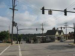
Downtown Madeira | |
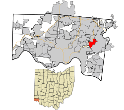 Location in Hamilton County and the state of Ohio. | |
| Coordinates: 39°11′18″N 84°22′6″W / 39.18833°N 84.36833°WCoordinates: 39°11′18″N 84°22′6″W / 39.18833°N 84.36833°W | |
| Country | United States |
| State | Ohio |
| County | Hamilton |
| Government | |
| • Mayor | Melisa Adrien (R)[1] |
| Area[2] | |
| • Total | 3.38 sq mi (8.75 km2) |
| • Land | 3.38 sq mi (8.75 km2) |
| • Water | 0 sq mi (0 km2) |
| Elevation[3] | 758 ft (231 m) |
| Population (2010)[4] | |
| • Total | 8,726 |
| • Estimate (2012[5]) | 8,809 |
| • Density | 2,581.7/sq mi (996.8/km2) |
| Time zone | Eastern (EST) (UTC-5) |
| • Summer (DST) | EDT (UTC-4) |
| ZIP code | 45243 |
| Area code(s) | 513 |
| FIPS code | 39-46312[6] |
| GNIS feature ID | 1061459[3] |
| Website |
www |
Madeira is a city in Hamilton County, Ohio, United States. The population was 8,726 at the 2010 census.[7] Madeira has a Council-Manager form of government, where the elected City Council appoints a paid City Manager to run the day-to-day operations of the city. Madeira is served by its own police department, while fire service is provided by the Madeira-Indian Hill Joint Fire District. Madeira is largely a residential community, with a small downtown and some light industry. Educational needs are served by the nationally ranked Madeira City Schools. Madeira is a suburb of Cincinnati. In 2007, BusinessWeek ranked it as one of the "Best Places to Raise Kids--For Less."[8]
Geography
Madeira is located at 39°11′18″N 84°22′6″W / 39.18833°N 84.36833°W (39.188310, -84.368366).[9]
According to the United States Census Bureau, the city has a total area of 3.38 square miles (8.75 km2), all land.[2]
It is bordered by:
- Indian Hill to the east
- Columbia Township to the south
- Cincinnati (Madisonville) to the south and west
- Silverton to the west
- Sycamore Township to the north
History
Madeira was largely laid out in 1871. Before this time the place was known as a post town, and was named for John Madeira who owned a large tract of land in the vicinity.[10]
Demographics
| Historical population | |||
|---|---|---|---|
| Census | Pop. | %± | |
| 1920 | 600 | — | |
| 1930 | 1,162 | 93.7% | |
| 1940 | 1,384 | 19.1% | |
| 1950 | 2,689 | 94.3% | |
| 1960 | 6,744 | 150.8% | |
| 1970 | 6,713 | −0.5% | |
| 1980 | 9,341 | 39.1% | |
| 1990 | 9,141 | −2.1% | |
| 2000 | 8,923 | −2.4% | |
| 2010 | 8,726 | −2.2% | |
| Est. 2015 | 8,976 | [11] | 2.9% |
| Sources:[6][12][13][14][15] | |||
2010 census
As of the census[4] of 2010, there were 8,726 people, 3,297 households, and 2,420 families residing in the city. The population density was 2,581.7 inhabitants per square mile (996.8/km2). There were 3,498 housing units at an average density of 1,034.9 per square mile (399.6/km2). The racial makeup of the city was 93.0% White, 2.5% African American, 0.1% Native American, 2.8% Asian, 0.3% from other races, and 1.2% from two or more races. Hispanic or Latino of any race were 2.3% of the population.
There were 3,297 households of which 36.3% had children under the age of 18 living with them, 62.1% were married couples living together, 8.3% had a female householder with no husband present, 3.0% had a male householder with no wife present, and 26.6% were non-families. 23.7% of all households were made up of individuals and 10.5% had someone living alone who was 65 years of age or older. The average household size was 2.58 and the average family size was 3.08.
The median age in the city was 42.9 years. 25.6% of residents were under the age of 18; 6% were between the ages of 18 and 24; 21.7% were from 25 to 44; 30.8% were from 45 to 64; and 16% were 65 years of age or older. The gender makeup of the city was 48.1% male and 51.9% female.
2000 census
As of the census[6] of 2000, there were 8,923 people, 3,383 households, and 2,472 families residing in the city. The population density was 2,651.0 people per square mile (1,022.3/km²). There were 3,484 housing units at an average density of 1,035.1 per square mile (399.2/km²). The racial makeup of the city was 95.70% White, 1.29% African American, 0.13% Native American, 1.89% Asian, 0.35% from other races, and 0.64% from two or more races. Hispanic or Latino of any race were 0.77% of the population.
There were 3,383 households out of which 35.8% had children under the age of 18 living with them, 62.9% were married couples living together, 7.7% had a female householder with no husband present, and 26.9% were non-families. 24.7% of all households were made up of individuals and 12.0% had someone living alone who was 65 years of age or older. The average household size was 2.55 and the average family size was 3.06.
In the city the population was spread out with 26.7% under the age of 18, 4.3% from 18 to 24, 25.0% from 25 to 44, 24.6% from 45 to 64, and 19.4% who were 65 years of age or older. The median age was 42 years. For every 100 females there were 89.2 males. For every 100 females age 18 and over, there were 82.8 males.
The median income for a household in the city was $59,626, and the median income for a family was $70,625. Males had a median income of $51,318 versus $38,172 for females. The per capita income for the city was $30,676. About 0.8% of families and 1.3% of the population were below the poverty line, including 0.3% of those under age 18 and 3.3% of those age 65 or over.
Notable people
- Clarence DeMar, marathoner
- Andrew Benintendi, baseball player
References
- ↑ "Hamilton County Officials 2016" (PDF). Hamilton County Board of Elections. 27 January 2016. p. 15. Retrieved 1 February 2016.
- 1 2 "US Gazetteer files 2010". United States Census Bureau. Retrieved 2013-01-06.
- 1 2 "US Board on Geographic Names". United States Geological Survey. 2007-10-25. Retrieved 2008-01-31.
- 1 2 "American FactFinder". United States Census Bureau. Retrieved 2013-01-06.
- ↑ "Population Estimates". United States Census Bureau. Retrieved 2013-06-17.
- 1 2 3 "American FactFinder". United States Census Bureau. Retrieved 2008-01-31.
- ↑ "Profile of General Population and Housing Characteristics: 2010 Demographic Profile Data (DP-1): Madeira city, Ohio". U.S. Census Bureau, American Factfinder. Retrieved October 30, 2012.
- ↑ Douglas McMillan (2007-11-16). "Best Places to Raise Your Kids, 2007". Business Week. Retrieved 2008-01-30.
- ↑ "US Gazetteer files: 2010, 2000, and 1990". United States Census Bureau. 2011-02-12. Retrieved 2011-04-23.
- ↑ Clarke, S. J. (1912). Cincinnati, the Queen City, 1788-1912, Volume 2. The S. J. Clarke Publishing Company. p. 531. Retrieved 2013-05-20.
- ↑ "Annual Estimates of the Resident Population for Incorporated Places: April 1, 2010 to July 1, 2015". Retrieved July 2, 2016.
- ↑ "Population: Ohio" (PDF). 1930 US Census. U.S. Census Bureau. Retrieved 28 November 2013.
- ↑ "Number of Inhabitants: Ohio" (PDF). 18th Census of the United States. U.S. Census Bureau. Retrieved 22 November 2013.
- ↑ "Ohio: Population and Housing Unit Counts" (PDF). U.S. Census Bureau. Retrieved 22 November 2013.
- ↑ "Incorporated Places and Minor Civil Divisions Datasets: Subcounty Population Estimates: April 1, 2010 to July 1, 2012". U.S. Census Bureau. Retrieved 25 November 2013.
External links
- City website
- Madeira City Schools
- ShopInMadeira.com - Madeira Chamber of Commerce
- Madeira Community Guide
Municipalities and communities of Hamilton County, Ohio, United States | ||
|---|---|---|
| Cities |  | |
| Villages | ||
| Townships | ||
| CDPs |
| |
| Other unincorporated communities | ||
| Footnotes | ‡This populated place also has portions in an adjacent county or counties | |