Mannahill, South Australia
| Mannahill South Australia | |||||||||||||
|---|---|---|---|---|---|---|---|---|---|---|---|---|---|
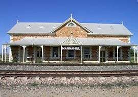 The railway station. | |||||||||||||
 Mannahill | |||||||||||||
| Coordinates | 32°25′50″S 139°59′08″E / 32.4305°S 139.9856°ECoordinates: 32°25′50″S 139°59′08″E / 32.4305°S 139.9856°E | ||||||||||||
| Population | 492 (shared with other localities in the “State Suburb of Yunta”) (2011 census)[1] | ||||||||||||
| Postcode(s) | 5440 | ||||||||||||
| Elevation | 370 m (1,214 ft) | ||||||||||||
| Location |
| ||||||||||||
| LGA(s) | Outback Communities Authority | ||||||||||||
| State electorate(s) | Stuart | ||||||||||||
| Federal Division(s) | Grey | ||||||||||||
| |||||||||||||
| Footnotes | Adjoining localities[2] | ||||||||||||
Mannahill (gazetted as Manna Hill)[2] is a settlement on the Barrier Highway and Indian Pacific railway line in South Australia.[3] Mannahill is in the Northeast Pastoral district and is one of the easternmost settlements in South Australia.[4] The population of Mannahill is 66 persons: 42 males and 24 females.
History
Mannahill was located on the stock route that passed from the Barrier Ranges in New South Wales to the then rail head at Terowie. The village also supported early gold mining activity at Mannahill and at Wadnaminga to the south. Mannahill was surveyed in the mid-1880s as a water-supply and maintenance point on the Peterborough to Cockburn railway line which was completed in 1887. The railway station had been previously constructed in 1886.[5]
In September 1886 a deputation, consisting of William Dening Glyde, M.L.C., Messrs. William Copley, William Henry Beaglehole, and David Bews, M.P.s, H. Nackin, and A. Champion, met the Commissioner of Crown Lands (Hon. J. Horn) seeking £600 to encourage further gold mining at the Mannahill Goldfields.[6]
Shortly afterwards this article appeared in the Melbourne Argus on 22 October 1886 in the context of the goldrush to the Mannahill goldfields:
The journey is principally across saltbush plains and low undulating hills, lightly timbered with mulga and ti-tree. Water and food on the road are both scarce and of inferior quality. The distance from Adelaide to Petersburg (now Peterborough) is 150 miles. The first train leaves Adelaide about 8 o'clock in the morning, and reaches Petersburg at 3pm. A second train leaves Adelaide shortly before 5 in the evening, but only goes as far as Terowie 10 miles from Petersburg, reaching Terowie at midnight. There is one train a day from Petersburg to Mannahill. This journey covers a distance of between 80 and 90 miles, over flat uninteresting country. Provision has to be made by travellers for their own refreshments until Mannahill is reached. Here there is a large hotel, capable of accommodating about 50 people. In shearing time the proprietor does a fair trade, shearers and teamsters from the surrounding stations being the principal customers. The country around here possesses a very dreary outlook.
The village still has the Mannahill Hotel which was built in 1889.[7] Mannahill Police Station is situated in Railway Terrace, Mannahill.[8] Local weather records have been kept at Mannahill for 109 years.[9]
Heritage listings
Mannahill has a number of heritage-listed sites, including:
Governance
Manna Hill is located within the federal division of Grey, the state electoral district of Stuart and the unincorporated area of South Australia.[12][13][2] As of 2016, the community within Manna Hill received municipal services from a South Australian agency, the Outback Communities Authority.[14]
References
- ↑ Australian Bureau of Statistics (31 October 2012). "Yunta". 2011 Census QuickStats. Retrieved 9 April 2016.
- 1 2 3 "Search result for "Mannahill (LOCB)" (Record no SA0042463) with the following layers selected - "Suburbs and Localities" and "Place names (gazetter)"". Property Location Browser. Government of South Australia. Retrieved 20 May 2016.
- ↑ "2905.0 - Statistical Geography: Volume 2 -- Census Geographic Areas, Australia, 2006". Australian Bureau of Statistics. Retrieved 8 December 2009.
- ↑ "May rainfall variable over SA Agricultural districts". Monthly Climate Summary - South Australian Regional Office. Bureau of Meteorology. Retrieved 1 June 2011.
- ↑ "Mannahill - SA". Explore Oz. I.T. Beyond Pty Ltd. Retrieved 21 May 2011.
- ↑ goldfields&searchLimits= "The Mannahill Goldfields" Check
|url=value (help). Trove Digitised newspapers. The South Australian Advertiser. Retrieved 21 May 2011. - ↑ "Mannahill Hotel". Campervan and Motorhome Club of Australia. Retrieved 1 June 2011.
- ↑ "Local police stations". South Australian Government. Retrieved 1 June 2011.
- ↑ "SIGNIFICANT WEATHER". FEBRUARY 1997. Bureau of Meteorology. Retrieved 1 June 2011.
- ↑ "Mannahill Railway Station Building, Water Tank, Goods Platform and Crane". South Australian Heritage Register. Department of Environment, Water and Natural Resources. Retrieved 12 February 2016.
- ↑ "'Antro' Woolshed & Shearers Kitchen, Bimbowrie Station". South Australian Heritage Register. Department of Environment, Water and Natural Resources. Retrieved 12 February 2016.
- ↑ "Federal electoral division of Grey" (PDF). Australian Electoral Commission. Retrieved 24 July 2015.
- ↑ "District of StuartBackground Profile". Electoral Commission SA. Retrieved 19 May 2016.
- ↑ "Copley". Outback Communities Authority. Retrieved 19 May 2016.