Marion County, Alabama
| Marion County, Alabama | |
|---|---|
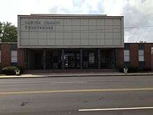 Marion County Courthouse in Hamilton | |
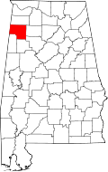 Location in the U.S. state of Alabama | |
 Alabama's location in the U.S. | |
| Founded | February 13, 1818 |
| Named for | Francis Marion |
| Seat | Hamilton |
| Largest city | Hamilton |
| Area | |
| • Total | 744 sq mi (1,927 km2) |
| • Land | 742 sq mi (1,922 km2) |
| • Water | 1.3 sq mi (3 km2), 0.2% |
| Population (est.) | |
| • (2015) | 30,168 |
| • Density | 41/sq mi (16/km²) |
| Congressional district | 4th |
| Time zone | Central: UTC-6/-5 |
| Website |
marioncountyalabama |
|
Footnotes:
| |
Marion County is a county of the U.S. state of Alabama. As of the 2010 census the population was 30,776.[1] The county seat is Hamilton.[2] The county was created by an act of the Alabama Territorial General Assembly on February 13, 1818. The county seat was originally established in Pikeville in 1820, and moved to Hamilton in 1881. The county was named for General Francis Marion of South Carolina.[3]
Marion County is located in the northwestern part of the state, bounded on the west by the state of Mississippi. It encompasses 743 square miles (1,920 km2). The county is a prohibition or dry county, however, the sale of alcohol is permitted within the cities of Guin, Hamilton, and Winfield.
History
The county was created by the Alabama Territorial General Assembly on February 13, 1818, preceding Alabama's statehood by almost two years. It was created from land acquired from the Chickasaw Indians by the Treaty of 1816. Marion County included all of its current territory and parts of what are now Winston, Walker, Fayette, and Lamar counties in Alabama as well as portions of present-day Lowndes, Monroe, and Itawamba counties in Mississippi. The county was named in honor of General Francis Marion (1732–1795), an American Revolutionary War hero from South Carolina who was known as "The Swamp Fox." Most early settlers of Marion County came from Kentucky and Tennessee after General Andrew Jackson established the Military Road. The first towns in the area were Pikeville, Hamilton (formerly Toll Gate), Winfield, and Guin.
Old Marion County CourthouseIn 1818, the first county courthouse was constructed at Cotton Gin Port, near Amory. It was moved in 1819 to the home of Henry Greer along the Buttachatchee River. Pikeville served as Marion County's first permanent county seat from 1820–82. The town is now abandoned, but the home of Judge John Dabney Terrell Sr., which served as the third county courthouse, still stands. In 1883, Hamilton became the county seat. The first courthouse in Hamilton was destroyed by fire on March 30, 1887, and the second courthouse, constructed in the same place, also burned. A new courthouse, constructed of local sandstone opened in 1901. In 1959, the building was significantly remodeled to give the structure its current 1950's "international style" design theme.
Geography
According to the U.S. Census Bureau, the county has a total area of 744 square miles (1,930 km2), of which 742 square miles (1,920 km2) is land and 1.3 square miles (3.4 km2) (0.2%) is water.[4]
Adjacent counties
- Franklin County (north)
- Winston County (east)
- Walker County (southeast)
- Fayette County (south)
- Lamar County (southwest)
- Monroe County, Mississippi (southwest)
- Itawamba County, Mississippi (west)
Demographics
| Historical population | |||
|---|---|---|---|
| Census | Pop. | %± | |
| 1830 | 4,058 | — | |
| 1840 | 5,847 | 44.1% | |
| 1850 | 7,833 | 34.0% | |
| 1860 | 11,182 | 42.8% | |
| 1870 | 6,059 | −45.8% | |
| 1880 | 9,364 | 54.5% | |
| 1890 | 11,347 | 21.2% | |
| 1900 | 14,494 | 27.7% | |
| 1910 | 17,495 | 20.7% | |
| 1920 | 22,008 | 25.8% | |
| 1930 | 25,967 | 18.0% | |
| 1940 | 28,776 | 10.8% | |
| 1950 | 27,264 | −5.3% | |
| 1960 | 21,837 | −19.9% | |
| 1970 | 23,788 | 8.9% | |
| 1980 | 30,041 | 26.3% | |
| 1990 | 29,830 | −0.7% | |
| 2000 | 31,214 | 4.6% | |
| 2010 | 30,776 | −1.4% | |
| Est. 2015 | 30,168 | [5] | −2.0% |
| U.S. Decennial Census[6] 1790–1960[7] 1900–1990[8] 1990–2000[9] 2010–2015[1] | |||
As of the census[10] of 2000, there were 31,214 people, 12,697 households, and 9,040 families residing in the county. The population density was 42 people per square mile (16/km2). There were 14,416 housing units at an average density of 19 per square mile (8/km2). The racial makeup of the county was 94.76% White, 3.3% Black or African American, 0.29% Native American, 0.20% Asian, 0.03% Pacific Islander, 0.39% from other races, and 0.70% from two or more races. 1.15% of the population were Hispanic or Latino of any race.
There were 12,697 households out of which 30.40% had children under the age of 18 living with them, 58.40% were married couples living together, 9.50% had a female householder with no husband present, and 28.80% were non-families. 26.50% of all households were made up of individuals and 12.70% had someone living alone who was 65 years of age or older. The average household size was 2.39 and the average family size was 2.87.
In the county the population was spread out with 22.50% under the age of 18, 8.20% from 18 to 24, 28.20% from 25 to 44, 25.20% from 45 to 64, and 15.80% who were 65 years of age or older. The median age was 39 years. For every 100 females there were 98.00 males. For every 100 females age 18 and over, there were 95.20 males.
The median income for a household in the county was $27,475, and the median income for a family was $34,359. Males had a median income of $26,913 versus $19,022 for females. The per capita income for the county was $15,321. About 12.00% of families and 15.60% of the population were below the poverty line, including 18.80% of those under age 18 and 20.00% of those age 65 or over.
2010 census
As of the census[11] of 2010, there were 30,776 people, 12,651 households, and 8,676 families residing in the county. The population density was 41 people per square mile (16/km2). There were 14,737 housing units at an average density of 19 per square mile (8/km2). The racial makeup of the county was 93.6% White, 3.8% Black or African American, 0.3% Native American, 0.2% Asian, 0.0% Pacific Islander, 0.9% from other races, and 1.1% from two or more races. 2.1% of the population were Hispanic or Latino of any race.
There were 12,651 households out of which 26.3% had children under the age of 18 living with them, 51.9% were married couples living together, 12.1% had a female householder with no husband present, and 31.4% were non-families. 28.4% of all households were made up of individuals and 13.1% had someone living alone who was 65 years of age or older. The average household size was 2.36 and the average family size was 2.87.
In the county the population was spread out with 21.7% under the age of 18, 7.7% from 18 to 24, 24.0% from 25 to 44, 28.4% from 45 to 64, and 18.3% who were 65 years of age or older. The median age was 42.8 years. For every 100 females there were 98.8 males. For every 100 females age 18 and over, there were 101.5 males.
The median income for a household in the county was $32,769, and the median income for a family was $44,223. Males had a median income of $34,089 versus $24,481 for females. The per capita income for the county was $19,030. About 13.3% of families and 17.8% of the population were below the poverty line, including 28.3% of those under age 18 and 12.7% of those age 65 or over.
Education
Two public school systems and one community college operate in Marion County. Marion County Schools and Winfield City Schools and Bevill State Community College Hamilton Campus.
Marion County School System
- Philips Elementary and High School (Bear Creek)
- Brilliant Elementary School
- Brilliant High School
- Guin Elementary School
- Marion County High School (Guin)
- Hackleburg Elementary and High School
- Hamilton Elementary School
- Hamilton Middle School
- Hamilton High School,
Marion County High School has won four state championships in 1A football with the most recent coming in 2011.[12]
Winfield City School System
- Winfield Elementary School
- Winfield Middle School
- Winfield High School
Events
- Jerry Brown Arts Festival - Hamilton (March)
- Neighbor Day - Hackleburg (Last Saturday in April)
- MayFest - Guin (Second Saturday in May)
- CoalFest - Brilliant (Memorial Day)
- Mule Day - Winfield (September)
- Buttahatchee River Fall Fest - Hamilton (October)
Media
Newspapers
The Court House at Hamilton burned in March 1887.[13] All newspapers before that date were lost in the flames as the Court House was the repository for them. The newspapers that we have record of after the fire are:
- The Marion County Herald - (1885–1890) The first newspaper available for The Marion Herald is April 5, 1887 due to the Court House Fire. The original date of beginning and editors have been lost with the Court House fire, but seems to have been started around April 1885. The Lamar News states that A. A. Wall had been with the Marion Herald before he started The Vernon Courier which was in 1886.[14] No earlier publishers of the paper have been found. The newspaper passed through several hands before closing its doors. Some of the notable editors include W. F. Green, James S. Clements, W. T. Gast, L. J. Clark, and others. The first editors were listed under the name The Herald Publishing Company.
- The Guin Dispatch (1888–1889) The Guin Dispatch was started around November 1888 by James S. Clements. It did not last long - only 13 issues. It closed its doors with the last issue of Feb 23, 1889.
- The Hamilton Times (1890–1893)
- The Hamilton Free Press (1893–1894)
- The Hamilton News Press (1895)
- The Hamilton Appeal (1896)
- The Guin Gazette (1897)
- The Gazette Appeal (1897)
- The Winfield Enterprise (1899–1900)
- The Marion County Democrat (1900–1904)
- The Marion County Republican (1908–1909)
- The Marion County News (1894, 1896 - 1959?)
- New Hope Record (1920)
- The Winfield Journal (1930–1959)
- The Hackleburg Sentinel (1937–1955)
- The Marion County Journal (1975)
- The Guin Gazette (1987)
- The Gazette Appeal (1987)
- The Journal Record (1976–present)
Transportation
Major highways
Rail
Air
Government
| Year | GOP | DNC | Others |
|---|---|---|---|
| 2016 | 86.9% 11,273 | 11.0% 1,432 | 2.1% 278 |
| 2012 | 80.1% 9,696 | 18.6% 2,249 | 1.3% 159 |
| 2008 | 77.2% 9,536 | 21.0% 2,600 | 1.8% 219 |
| 2004 | 69.8% 8,983 | 29.6% 3,808 | 0.6% 84 |
| 2000 | 58.8% 6,910 | 39.1% 4,600 | 2.1% 246 |
Communities
Cities
- Guin
- Haleyville (partly in Winston County)
- Hamilton (county seat)
- Winfield (partly in Fayette County)
Towns
- Bear Creek
- Brilliant
- Glen Allen (partly in Fayette County)
- Gu-Win (partly in Fayette County)
- Hackleburg
- Twin
Unincorporated communities
- Barnesville
- Bexar
- Pigeye
- Pull Tight
- Shottsville
- South Haleyville
- Texas
- Gravel Springs
- Byrd
Ghost town
See also
- National Register of Historic Places listings in Marion County, Alabama
- Properties on the Alabama Register of Landmarks and Heritage in Marion County, Alabama
References
- 1 2 "State & County QuickFacts". United States Census Bureau. Retrieved May 16, 2014.
- ↑ "Find a County". National Association of Counties. Retrieved 2011-06-07.
- ↑ Gannett, Henry (1905). The Origin of Certain Place Names in the United States. U.S. Government Printing Office. p. 200.
- ↑ "2010 Census Gazetteer Files". United States Census Bureau. August 22, 2012. Retrieved August 22, 2015.
- ↑ "County Totals Dataset: Population, Population Change and Estimated Components of Population Change: April 1, 2010 to July 1, 2015". Retrieved July 2, 2016.
- ↑ "U.S. Decennial Census". United States Census Bureau. Retrieved August 22, 2015.
- ↑ "Historical Census Browser". University of Virginia Library. Retrieved August 22, 2015.
- ↑ Forstall, Richard L., ed. (March 24, 1995). "Population of Counties by Decennial Census: 1900 to 1990". United States Census Bureau. Retrieved August 22, 2015.
- ↑ "Census 2000 PHC-T-4. Ranking Tables for Counties: 1990 and 2000" (PDF). United States Census Bureau. April 2, 2001. Retrieved August 22, 2015.
- ↑ "American FactFinder". United States Census Bureau. Retrieved 2011-05-14.
- ↑ "American FactFinder". United States Census Bureau. Retrieved 2015-08-02.
- ↑ "Marion County Alabama Takes 1A High School Football Title Over Linden". Rip the Page. December 2, 2011.
- ↑ Marion Herald April 5, 1887 pg 8
- ↑ The Lamar News of May 20, 1886
- ↑ "Dave Leip's Atlas of U.S. Presidential Elections". Retrieved November 21, 2016.
External links
 |
Franklin County | | ||
| Itawamba County, Mississippi | |
Winston County | ||
| ||||
| | ||||
| Lamar County and Monroe County, Mississippi | Fayette County | Walker County |
Municipalities and communities of Marion County, Alabama, United States | ||
|---|---|---|
| Cities | | |
| Towns | ||
| Unincorporated communities | ||
| Ghost town | ||
| Footnotes | ‡This populated place also has portions in an adjacent county or counties | |
Coordinates: 34°08′11″N 87°53′03″W / 34.13639°N 87.88417°W