Macon County, Alabama
| Macon County, Alabama | |
|---|---|
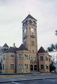 | |
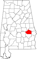 Location in the U.S. state of Alabama | |
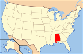 Alabama's location in the U.S. | |
| Founded | December 18, 1832 |
| Named for | Nathaniel Macon |
| Seat | Tuskegee |
| Largest city | Tuskegee |
| Area | |
| • Total | 613 sq mi (1,588 km2) |
| • Land | 609 sq mi (1,577 km2) |
| • Water | 4.3 sq mi (11 km2), 0.7% |
| Population (est.) | |
| • (2015) | 19,105 |
| • Density | 35/sq mi (14/km²) |
| Congressional district | 3rd |
| Time zone | Central: UTC-6/-5 |
|
Footnotes:
| |
Macon County is a county in the U.S. state of Alabama. As of the 2010 census, the population was 21,452.[1] Its county seat is Tuskegee.[2] Its name is in honor of Nathaniel Macon, a member of the United States Senate from North Carolina.[3]
Developed for cotton plantation agriculture in the nineteenth century, the county is considered within the Black Belt of the South. It has had a majority-black population since before the American Civil War.
In the 2004 U.S. Presidential Election, Macon had the third-highest number of voters in the state for the Democratic Senator John Kerry. It was the setting of the 1974 movie, Macon County Line. The Sheriff of Macon County is Andre Brunson, he also was the former strength coach at Tuskegee University.
History
For thousands of years, this area was inhabited by varying cultures of indigenous peoples. The historic tribes encountered by European explorers were the Creek people, descendants of the Mississippian culture.
Macon County was established by European Americans on December 18, 1832, from land ceded by the Creek, following the US Congress' passage of the Indian Removal Act of 1830. The Creek were removed to Indian Territory west of the Mississippi River. The new settlers brought slaves with them from eastern areas of the South, or purchased them in slave markets, such as at New Orleans. They developed the county for large cotton plantations.
In the first half of the twentieth century, thousands of blacks migrated out of the county to industrial cities in the North and Midwest for job opportunities, and the chance to escape legal segregation. Those who remained have struggled for employment in the mostly rural county, and population has declined by about one third since 1950.
Before 1983, Macon County was primarily known as the home of historic Tuskegee Institute, now Tuskegee University, and its noted founder and first president, Dr. Booker T. Washington. The quiet hamlet began to awaken in 1983 when parimutuel gambling arrived in the form of VictoryLand greyhound racing.[4]
Geography
According to the U.S. Census Bureau, the county has a total area of 613 square miles (1,590 km2), of which 609 square miles (1,580 km2) is land and 4.3 square miles (11 km2) (0.7%) is water.[5]
Major highways
.svg.png) Interstate 85
Interstate 85 U.S. Highway 29
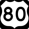 U.S. Highway 80
 State Route 14
 State Route 49
 State Route 81
 State Route 138
 State Route 186
 State Route 199
 State Route 229
Adjacent counties
- Tallapoosa County (north)
- Lee County (northeast)
- Russell County (southeast)
- Bullock County (south)
- Montgomery County (southwest)
- Elmore County (northwest)
National protected areas
- Tuskegee Airmen National Historic Site
- Tuskegee Institute National Historic Site
- Tuskegee National Forest
Demographics
| Historical population | |||
|---|---|---|---|
| Census | Pop. | %± | |
| 1840 | 11,247 | — | |
| 1850 | 26,898 | 139.2% | |
| 1860 | 26,802 | −0.4% | |
| 1870 | 17,727 | −33.9% | |
| 1880 | 17,371 | −2.0% | |
| 1890 | 18,439 | 6.1% | |
| 1900 | 23,126 | 25.4% | |
| 1910 | 26,049 | 12.6% | |
| 1920 | 23,561 | −9.6% | |
| 1930 | 27,103 | 15.0% | |
| 1940 | 27,654 | 2.0% | |
| 1950 | 30,561 | 10.5% | |
| 1960 | 26,717 | −12.6% | |
| 1970 | 24,841 | −7.0% | |
| 1980 | 26,829 | 8.0% | |
| 1990 | 24,928 | −7.1% | |
| 2000 | 24,105 | −3.3% | |
| 2010 | 21,452 | −11.0% | |
| Est. 2015 | 19,105 | [6] | −10.9% |
| U.S. Decennial Census[7] 1790–1960[8] 1900–1990[9] 1990–2000[10] 2010–2015[1] | |||
As of the 2010 United States Census, there were 21,452 people residing in the county. 82.6% were Black or African American, 15.5% White, 0.4% Asian, 0.1% Native American, 0.3% of some other race and 1.1% of two or more races. 1.1% were Hispanic or Latino (of any race).
As of the census[11] of 2000, there were 24,105 people, 8,950 households, and 5,543 families residing in the county. The population density was 40 people per square mile (15/km2). There were 10,627 housing units at an average density of 17 per square mile (7/km2). The racial makeup of the county was 84.64% Black or African American, 13.96% White, 0.16% Native American, 0.38% Asian, 0.13% from other races, and 0.73% from two or more races. 0.72% of the population were Hispanic or Latino of any race.
There were 8,950 households out of which 28.40% had children under the age of 18 living with them, 31.70% were married couples living together, 25.80% had a female householder with no husband present, and 38.10% were non-families. 33.00% of all households were made up of individuals and 11.90% had someone living alone who was 65 years of age or older. The average household size was 2.44 and the average family size was 3.13.
In the county the population was spread out with 25.20% under the age of 18, 16.90% from 18 to 24, 22.90% from 25 to 44, 21.00% from 45 to 64, and 14.00% who were 65 years of age or older. The median age was 32 years. For every 100 females there were 85.00 males. For every 100 females age 18 and over, there were 80.30 males.
The median income for a household in the county was $21,180, and the median income for a family was $28,511. Males had a median income of $25,971 versus $21,773 for females. The per capita income for the county was $13,714. About 26.80% of families and 32.80% of the population were below the poverty line, including 43.80% of those under age 18 and 26.00% of those age 65 or over.
Government
| Year | GOP | DNC | Others |
|---|---|---|---|
| 2016 | 15.9% 1,394 | 82.5% 7,237 | 1.6% 142 |
| 2012 | 12.7% 1,322 | 87.1% 9,045 | 0.2% 18 |
| 2008 | 12.8% 1,396 | 86.9% 9,450 | 0.3% 31 |
| 2004 | 16.7% 1,570 | 82.9% 7,800 | 0.4% 37 |
| 2000 | 12.4% 1,091 | 86.8% 7,665 | 0.8% 75 |
Communities
City
- Tuskegee (county seat)
Towns
- Franklin
- Notasulga (partly in Lee County)
- Shorter
Unincorporated communities
Places of interest
Macon County is home to the Tuskegee University, a historically black college; Tuskegee National Forest, Tuskegee Lake, the Tuskegee Human and Civil Rights Museum, and Moton Field, the training site of the Tuskegee Airmen.
See also
- National Register of Historic Places listings in Macon County, Alabama
- Properties on the Alabama Register of Landmarks and Heritage in Macon County, Alabama
References
- 1 2 "State & County QuickFacts". United States Census Bureau. Retrieved May 16, 2014.
- ↑ "Find a County". National Association of Counties. Retrieved 2011-06-07.
- ↑ Gannett, Henry (1905). The Origin of Certain Place Names in the United States. U.S. Government Printing Office. p. 195.
- ↑ Hope for Families & Comty Serv., Inc.. v. Warren, 721 F.Supp.2d 1079, 1086 (M.D. Ala. 2010)
- ↑ "2010 Census Gazetteer Files". United States Census Bureau. August 22, 2012. Retrieved August 22, 2015.
- ↑ "County Totals Dataset: Population, Population Change and Estimated Components of Population Change: April 1, 2010 to July 1, 2015". Retrieved July 2, 2016.
- ↑ "U.S. Decennial Census". United States Census Bureau. Retrieved August 22, 2015.
- ↑ "Historical Census Browser". University of Virginia Library. Retrieved August 22, 2015.
- ↑ Forstall, Richard L., ed. (March 24, 1995). "Population of Counties by Decennial Census: 1900 to 1990". United States Census Bureau. Retrieved August 22, 2015.
- ↑ "Census 2000 PHC-T-4. Ranking Tables for Counties: 1990 and 2000" (PDF). United States Census Bureau. April 2, 2001. Retrieved August 22, 2015.
- ↑ "American FactFinder". United States Census Bureau. Retrieved 2011-05-14.
- ↑ "Dave Leip's Atlas of U.S. Presidential Elections". Retrieved November 21, 2016.
 |
Elmore County | Tallapoosa County | Lee County | |
| |
||||
| ||||
| | ||||
| Montgomery County | Bullock County | Russell County |
Municipalities and communities of Macon County, Alabama, United States | ||
|---|---|---|
| City | | |
| Towns | ||
| Unincorporated communities | ||
| Footnotes | ‡This populated place also has portions in an adjacent county or counties | |
Coordinates: 32°23′07″N 85°41′37″W / 32.38528°N 85.69361°W