Mormeal
| Mormeal | |
|---|---|
| Irish transcription(s) | |
| • Derivation: | Mír Mhíchíl |
| • Meaning: | "Michael's portion" |
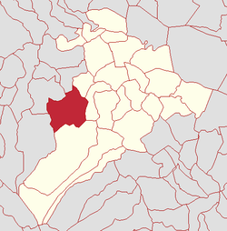 | |
 Mormeal Mormeal shown within Northern Ireland | |
| Coordinates: 54°47′28″N 6°44′38″W / 54.791°N 6.744°WCoordinates: 54°47′28″N 6°44′38″W / 54.791°N 6.744°W | |
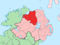
| Country | Northern Ireland |
| County | County Londonderry |
| Barony | Loughinsholin |
| Civil parish | Kilcronaghan |
| Plantation grant | Church lands |
| First recorded | 1654 |
| Government | |
| • Council | Magherafelt District Council |
| • Ward | Tobermore |
| Area[1] | |
| • Total | 217.65 ha (537.82 acres) |
| Irish grid ref | H8094 |
Mormeal (locally [ˌmɔrˈmeːl] and [ˌmɔrˈmiːl], from Irish Mír Mhíchíl, meaning "Michael's portion"[2]) is a townland lying within the civil parish of Kilcronaghan, County Londonderry, Northern Ireland. It lies in the west of the parish with the Altagoan river to its west forming the parish boundary with Ballynascreen. It is bounded by the townlands of: Brackaghlislea, Drumard, Duntibryan, Gortnaskey, Granny, Tamnyaskey. It wasn't apportioned to any of the London livery companies, being kept as church lands.[3]
The townland is currently part of Tobermore electoral ward of Magherafelt District Council, however in 1926 it was part of Tobermore district electoral division as part of the Maghera division of Magherafelt Rural District.[4] It was also part of the historic barony of Loughinsholin.[3]
Etymology
The actual Irish origin of Mormeal is unknown with several different variants provided, most notably by Alfred Munn Moore. The most recent translation as of 2002 states its origin as being; Mír Mhíchíl, meaning Michael's portion.[5] Older origins include:
- Mor-meall meaning "great hillock".[3] Mór Mael(án) in modern Irish.
- Baile mor miol meaning "town of the monsters".[3]
- Magh-adhair m-bheal (pronounced "mawr-meal") meaning "plain of the fire, or adoration, of the god Belus (the sun)".[3]
History
Along with the townlands of Granny, Tamnyaskey, and Tullyroan, Mormeal comprises the four townlands that make up the Bishop of Derrys lands in the parish. Prior to the Plantation of Ulster, these four townlands constituted the termon (or erenagh) land of the parish, and were known as "Ballintrolla, Derreskerdan, Dirrygrinagh et Kellynahawla". Despite these townlands being in the same location as the later townlands, it is now impossible to match their names accurately.[6]
The ruins of the ancient parish church of Kilcronaghan lie within the townland of Mormeal. In the east of the townland on a hill (438 ft.) lies an ancient ráth, and one on another hill (450 ft.) to the south.
Statistics
|
|
| ||||||||||||||||||||||||||||||||||||||||||||||||
See also
References
- ↑ Northern Ireland Environment Agency. "NIEA Map Viewer". Retrieved 27 January 2012.
- ↑ Toner, Gregory: Place-Names of Northern Ireland, page 130-1. Queen's University of Belfast, 1996, ISBN 0-85389-613-5
- 1 2 3 4 5 6 7 Notes on the Place Names of the Parishes and Townlands of the County of Londonderry, 1925, Alfred Moore Munn, Clerk of the Crown and Peace of the City and County of Londonderry
- 1 2 3 4 HistPop; County and County Borough of Londonderry, 1926, page 27
- 1 2 Place Names NI - Mormeal
- ↑ Toner, Gregory: Place-Names of Northern Ireland, page 112. Queen's University of Belfast, 1996, ISBN 0-85389-613-5
- 1 2 3 4 5 6 HistPop; Area, population and number of houses, Vol. III, Ireland, 1881, page 698
- ↑ HistPop; County of Londonderry, 1851, page 241