Mount Kirishima
| Mount Kirishima | |
|---|---|
 Kirishima Volcano Group | |
| Highest point | |
| Peak | Karakuni-dake |
| Elevation | 1,700 m (5,600 ft) |
| Coordinates | 31°56′17″N 130°51′41″E / 31.93806°N 130.86139°ECoordinates: 31°56′17″N 130°51′41″E / 31.93806°N 130.86139°E |
| Geography | |
| Country | Japan |
| States/Provinces | Kagoshima prefecture and Miyazaki prefecture |
Mount Kirishima (霧島山 Kirishimayama) is a 1700 meter high active volcano group in Kagoshima Prefecture and Miyazaki Prefecture, Kyushu, Japan. Numerous eruptions have been recorded since 742. Very strong eruptions happened in 788, 1716 and 1717. Augite-hypersthene andesite is the dominant rock type.[1]
The highest peak is Mount Karakuni (韓国岳 Karakunidake) (1700 m). Other peaks are Takachiho-no-mine (高千穂峰) (1573 m) and Shinmoedake (新燃岳), both active volcanos. They are part of Kirishima-Yaku National Park near Kirishima City. Upon the summit of Takachiho was stuck the mysterious spear Ama-no-Sakahoko, by the legendary Ninigi-no-Mikoto. Mount Kirishima is considered one of the 100 Famous Japanese Mountains. The area is often foggy, and it is believed that the name Kirishima comes from the mountain looking like an island in the fog.
The Kongō-class battlecruiser Kirishima of the Imperial Japanese Navy, and the Kongō-class guided missile destroyer Kirishima of the Japan Maritime Self-Defense Force were both named after this mountain.
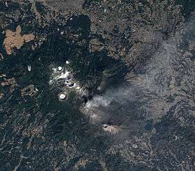
Shinmoedake erupted in January 2011 and again in March 2011.
- Kirishima Volcano Group
 Takachihonomine Volcano
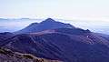 Shinmoedake Volcano (front) & Takachihonomine Volcano
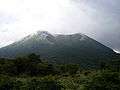 Ohachi Volcano
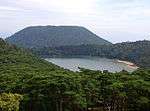 Rokkan'nonmiike Volcano (front) & Koshikidake Volcano (background)
 Onamiike Volcano
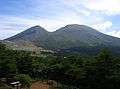 Karakunidake Volcano
 Hudouike Volcano
 Hinamoridake Volcano
 Kurinodake Volcano
See also
References
External links
| Wikimedia Commons has media related to Mount Kirishima. |
- Kirishimayama - Japan Meteorological Agency (Japanese)
- "Kirishimayama: National catalogue of the active volcanoes in Japan" (PDF). - Japan Meteorological Agency
- Kirishima Volcano - Geological Survey of Japan
- Kirishimayama - Smithsonian Institution: Global Volcanism Program
- Kirishima Geopark - The Kirishima Geopark Council