| [3] |
Name on the Register[4] |
Image |
Date listed[5] |
Location |
City or town |
Description |
|---|
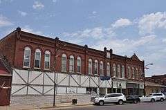
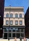
| 1 |
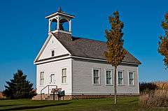
Bennington No. 4 |
|
000000002001-01-16-0000January 16, 2001
(#00001651) |
Junction of Bennington and Sage Rds.
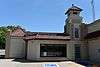
42°36′00″N 92°17′50″W / 42.6°N 92.297222°W / 42.6; -92.297222 (Bennington No. 4) |
Waterloo |
|
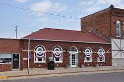
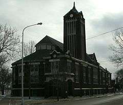
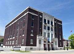
| 2 |
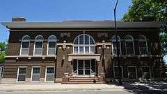
Black Hawk County Soldiers Memorial Hall |
|
000000001988-11-29-0000November 29, 1988
(#88001322) |
194 W. 5th St.
42°29′44″N 92°20′18″W / 42.495556°N 92.338333°W / 42.495556; -92.338333 (Black Hawk County Soldiers Memorial Hall) |
Waterloo |
|
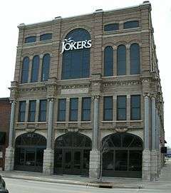
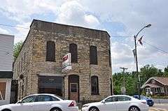
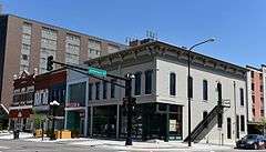
| 3 |
Black Hawk Hotel |
|
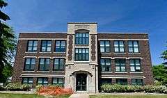
000000002002-12-19-0000December 19, 2002
(#02001542) |
115-119 Main St.
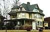
42°32′15″N 92°26′44″W / 42.5375°N 92.445556°W / 42.5375; -92.445556 (Black Hawk Hotel) |
Cedar Falls |
|
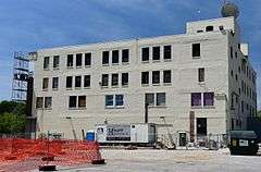
| 4 |
Campbell Baking Company |
|
000000002016-05-02-0000May 2, 2016
(#16000213) |
325 Commercial St.
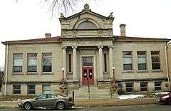
42°29′49″N 92°20′32″W / 42.496808°N 92.342256°W / 42.496808; -92.342256 (Campbell Baking Company) |
Waterloo |
|
| 5 |
Cedar Falls Ice House |
|
000000001977-10-21-0000October 21, 1977
(#77000494) |
Franklin Ave. and 1st St.
42°32′19″N 92°26′55″W / 42.538611°N 92.448611°W / 42.538611; -92.448611 (Cedar Falls Ice House) |
Cedar Falls |
|
| 6 |
Cedar Falls Independent Order of Odd Fellows |
|
000000001997-05-02-0000May 2, 1997
(#97000384) |
401-403 Main St.
42°32′05″N 92°26′41″W / 42.534722°N 92.444722°W / 42.534722; -92.444722 (Cedar Falls Independent Order of Odd Fellows) |
Cedar Falls |
|
| 7 |
Cedar Falls Post Office |
|
000000002016-03-08-0000March 8, 2016
(#16000057) |
217 Washington St.
42°32′10″N 92°26′49″W / 42.536155°N 92.446832°W / 42.536155; -92.446832 (Cedar Falls Post Office) |
Cedar Falls |
|
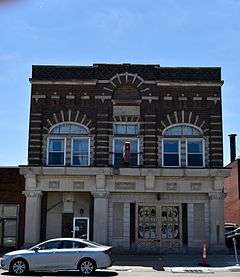
| 8 |
Chapple and Young Block |
|
000000002002-09-20-0000September 20, 2002
(#02001025) |
316-318-320 Main St.
42°18′48″N 92°11′21″W / 42.3133°N 92.1892°W / 42.3133; -92.1892 (Chapple and Young Block) |
La Porte City |
|
| 9 |
Chicago Great Western Railroad-Waterloo Freight Depot |
Upload image |
000000001997-01-17-0000January 17, 1997
(#88001325) |
6th St.
42°29′41″N 92°20′01″W / 42.494722°N 92.333611°W / 42.494722; -92.333611 (Chicago Great Western Railroad-Waterloo Freight Depot) |
Waterloo |
|
| 10 |
Cotton Theater |
|
000000001993-07-23-0000July 23, 1993
(#93000764) |
103 Main St.
42°32′14″N 92°26′42″W / 42.537222°N 92.445°W / 42.537222; -92.445 (Cotton Theater) |
Cedar Falls |
|
| 11 |
Dunkerton Bridge |
Upload image |
000000001998-06-25-0000June 25, 1998
(#98000768) |
Local street over Crane Creek
42°34′23″N 92°09′38″W / 42.573056°N 92.160556°W / 42.573056; -92.160556 (Dunkerton Bridge) |
Dunkerton |
|
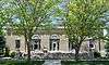
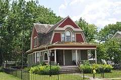
| 12 |
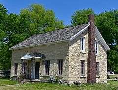
Dunsmore House |
|
000000001977-11-17-0000November 17, 1977
(#77000497) |
902 Logan Ave.
42°30′48″N 92°20′14″W / 42.513333°N 92.337222°W / 42.513333; -92.337222 (Dunsmore House) |
Waterloo |
|
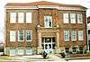
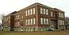
| 13 |
Emerson School |
|
000000002004-12-29-0000December 29, 2004
(#04001403) |
314 Randolph St.
42°29′34″N 92°20′51″W / 42.492778°N 92.3475°W / 42.492778; -92.3475 (Emerson School) |
Waterloo |
|
| 14 |
Fire Station No. 2 |
|
000000001988-11-29-0000November 29, 1988
(#88001321) |
716 Commercial St.
42°29′38″N 92°20′17″W / 42.493889°N 92.338056°W / 42.493889; -92.338056 (Fire Station No. 2) |
Waterloo |
|
| 15 |
The Fowler Company Building |
|
000000002009-09-16-0000September 16, 2009
(#09000712) |
226-228 E. 4th St.
42°29′54″N 92°20′08″W / 42.498442°N 92.335683°W / 42.498442; -92.335683 (The Fowler Company Building) |
Waterloo |
|
| 16 |
Clement B. Gingrich House |
|
000000001996-12-04-0000December 4, 1996
(#96001371) |
300 Walnut St.
42°18′51″N 92°11′18″W / 42.3142°N 92.1883°W / 42.3142; -92.1883 (Clement B. Gingrich House) |
La Porte City |
|
| 17 |
Grace Methodist Episcopal Church |
|
000000002011-10-06-0000October 6, 2011
(#11000719) |
633 Walnut St.
42°30′04″N 92°19′51″W / 42.500984°N 92.33095°W / 42.500984; -92.33095 (Grace Methodist Episcopal Church) |
Waterloo |
|
| 18 |
Highland Historic District |
|
000000001984-09-24-0000September 24, 1984
(#84001209) |
Roughly bounded by Independence Ave. and Steely, Idaho, and Vine Sts.
42°30′01″N 92°18′42″W / 42.500278°N 92.311667°W / 42.500278; -92.311667 (Highland Historic District) |
Waterloo |
|
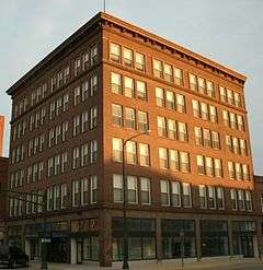
| 19 |
Hotel Russell-Lamson |
|
000000001988-11-29-0000November 29, 1988
(#88001324) |
201-215 W. 5th St.
42°29′39″N 92°20′19″W / 42.494167°N 92.338611°W / 42.494167; -92.338611 (Hotel Russell-Lamson) |
Waterloo |
|
| 20 |
La Porte City Station |
|
000000001979-03-13-0000March 13, 1979
(#79003781) |
202 E. Main St.
42°18′55″N 92°11′32″W / 42.3153°N 92.1922°W / 42.3153; -92.1922 (La Porte City Station) |
La Porte City |
La Porte City's current city hall
|
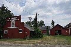
| 21 |
August H.J. and Justena Lange Farmstead Historic District |
|
000000001997-05-14-0000May 14, 1997
(#97000385) |
8214 Spring Creek Rd.
42°22′53″N 92°04′29″W / 42.3814°N 92.0747°W / 42.3814; -92.0747 (August H.J. and Justena Lange Farmstead Historic District) |
La Porte City |
|
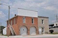
| 22 |
LaPorte City Town Hall and Fire Station |
|
000000001977-05-12-0000May 12, 1977
(#77000496) |
413 Chestnut
42°18′49″N 92°11′30″W / 42.3136°N 92.1917°W / 42.3136; -92.1917 (LaPorte City Town Hall and Fire Station) |
La Porte City |
La Porte City's former city hall and fire station
|
| 23 |
Marsh-Place Building |
|
000000001998-10-22-0000October 22, 1998
(#98001272) |
627 Sycamore St.
42°29′51″N 92°20′04″W / 42.4975°N 92.334444°W / 42.4975; -92.334444 (Marsh-Place Building) |
Waterloo |
|
| 24 |
Master Service Station |
|
000000002011-02-07-0000February 7, 2011
(#10001204) |
500 Jefferson St.
42°29′42″N 92°20′30″W / 42.495°N 92.341667°W / 42.495; -92.341667 (Master Service Station) |
Waterloo |
|
| 25 |
John N. and Mary McQuilken House |
|
000000001994-09-08-0000September 8, 1994
(#94001097) |
602 Commercial St.
42°18′46″N 92°11′35″W / 42.3128°N 92.1931°W / 42.3128; -92.1931 (John N. and Mary McQuilken House) |
La Porte City |
|
| 26 |
James Newell Barn |
Upload image |
000000001976-12-12-0000December 12, 1976
(#76000734) |
North of Cedar Falls off U.S. Route 218
42°37′01″N 92°29′38″W / 42.616944°N 92.493889°W / 42.616944; -92.493889 (James Newell Barn) |
Cedar Falls |
|
| 27 |
Overland Waterloo Company Building |
|
000000002014-09-22-0000September 22, 2014
(#14000663) |
500 E. 4th St.
42°30′02″N 92°19′58″W / 42.5005°N 92.3328°W / 42.5005; -92.3328 (Overland Waterloo Company Building) |
Waterloo |
|
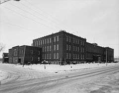
| 28 |
Rath Packing Company Administration Building |
|
000000002008-12-10-0000December 10, 2008
(#08001162) |
1515 E. Sycamore St., 208-212 Elm St.
42°29′33″N 92°19′26″W / 42.4925°N 92.323889°W / 42.4925; -92.323889 (Rath Packing Company Administration Building) |
Waterloo |
|
| 29 |
Roosevelt Elementary School |
|
000000002004-12-30-0000December 30, 2004
(#04001402) |
200 E. Arlington St.
42°31′06″N 92°20′11″W / 42.518333°N 92.336389°W / 42.518333; -92.336389 (Roosevelt Elementary School) |
Waterloo |
|
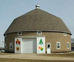
| 30 |
Round Barn, Washington Township |
Upload image |
000000001986-06-30-0000June 30, 1986
(#86001417) |
Off U.S. Route 218
42°35′07″N 92°27′40″W / 42.585278°N 92.461111°W / 42.585278; -92.461111 (Round Barn, Washington Township) |
Washington Township |
|
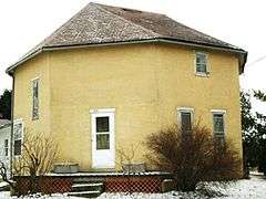
| 31 |
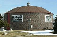
C.A. Rownd Round Barn |
|
000000001986-11-19-0000November 19, 1986
(#86003193) |
5102 S. Main
42°29′50″N 92°27′47″W / 42.497222°N 92.463056°W / 42.497222; -92.463056 (C.A. Rownd Round Barn) |
Cedar Falls |
|
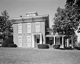
| 32 |
Rensselaer Russell House |
|
000000001973-07-05-0000July 5, 1973
(#73000722) |
520 W. 3rd St.
42°29′39″N 92°20′44″W / 42.494167°N 92.345556°W / 42.494167; -92.345556 (Rensselaer Russell House) |
Waterloo |
|
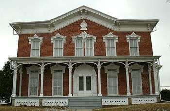
| 33 |
Snowden House |
|
000000001977-09-14-0000September 14, 1977
(#77000498) |
306 Washington St.
42°29′39″N 92°20′44″W / 42.494167°N 92.345556°W / 42.494167; -92.345556 (Snowden House) |
Waterloo |
|
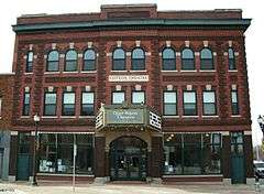
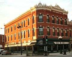
| 34 |
Syndicate Block |
|
000000002005-12-21-0000December 21, 2005
(#05001429) |
206, 208, 210, 212, and 216 Main St.
42°18′54″N 92°11′24″W / 42.315°N 92.19°W / 42.315; -92.19 (Syndicate Block) |
La Porte City |
|
| 35 |
Walnut Street Baptist Church |
|
000000002000-08-16-0000August 16, 2000
(#00000983) |
415 Walnut St.
42°30′09″N 92°20′02″W / 42.5025°N 92.333889°W / 42.5025; -92.333889 (Walnut Street Baptist Church) |
Waterloo |
|
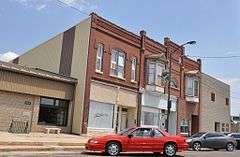
| 36 |
Dr. Jesse Wasson Building |
|
000000001999-10-07-0000October 7, 1999
(#99001239) |
201 Main St.
42°18′54″N 92°11′34″W / 42.315°N 92.1928°W / 42.315; -92.1928 (Dr. Jesse Wasson Building) |
La Porte City |
|
| 37 |
William Waterfield House |
|
000000001978-10-19-0000October 19, 1978
(#78001206) |
308 3rd St., S.
42°27′54″N 92°13′11″W / 42.465°N 92.219722°W / 42.465; -92.219722 (William Waterfield House) |
Raymond |
|
| 38 |
Waterloo East Commercial Historic District |
|
000000002011-11-18-0000November 18, 2011
(#11000813) |
128-329 E. 4th, 612-616 Mulberry, 501-632 Sycamore Sts.
42°29′56″N 92°20′06″W / 42.498889°N 92.335°W / 42.498889; -92.335 (Waterloo East Commercial Historic District) |
Waterloo |
Iowa's Main Street Commercial Architecture MPS
|
| 39 |
Waterloo West Commercial Historic District |
|
000000002014-09-22-0000September 22, 2014
(#14000664) |
217-333 W. 4th., 301-317 W. 5th & 612-716 Jefferson Sts.
42°29′39″N 92°20′26″W / 42.4943°N 92.3406°W / 42.4943; -92.3406 (Waterloo West Commercial Historic District) |
Waterloo |
|
| 40 |
Waterloo Masonic Temple |
|
000000002013-12-18-0000December 18, 2013
(#13000921) |
325 E. Park Avenue
42°30′02″N 92°20′09″W / 42.500556°N 92.335709°W / 42.500556; -92.335709 (Waterloo Masonic Temple) |
Waterloo |
|
| 41 |
Waterloo Public Library (West Branch) |
|
000000001983-05-23-0000May 23, 1983
(#83000342) |
528 W. 4th St.
42°29′33″N 92°20′35″W / 42.4925°N 92.343056°W / 42.4925; -92.343056 (Waterloo Public Library (West Branch)) |
Waterloo |
|
| 42 |
Waterloo Public Library-East Side Branch |
|
000000001988-11-29-0000November 29, 1988
(#88001323) |
626 Mulberry St.
42°29′56″N 92°19′59″W / 42.498889°N 92.333056°W / 42.498889; -92.333056 (Waterloo Public Library-East Side Branch) |
Waterloo |
|
| 43 |
Henry Weis House |
|
000000001989-10-30-0000October 30, 1989
(#89001779) |
800 W. 4th St.
42°29′26″N 92°20′45″W / 42.490556°N 92.345833°W / 42.490556; -92.345833 (Henry Weis House) |
Waterloo |
|
| 44 |
Whittier School |
|
000000002004-12-30-0000December 30, 2004
(#04001400) |
1500 3rd St., W.
42°29′14″N 92°21′22″W / 42.487222°N 92.356111°W / 42.487222; -92.356111 (Whittier School) |
Waterloo |
|
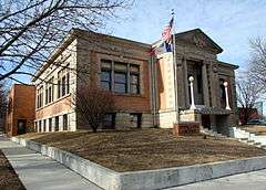
| 45 |
YMCA Building |
|
000000001983-07-07-0000July 7, 1983
(#83000343) |
154 W. 4th St.
42°29′37″N 92°20′27″W / 42.493611°N 92.340833°W / 42.493611; -92.340833 (YMCA Building) |
Waterloo |
|