National Register of Historic Places listings in Scott County, Iowa
| This article is part of a series on |
| National Register of Historic Places in Scott County, Iowa |
|---|
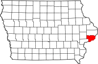 |
| Scott County |
| Downtown Davenport |
| East Davenport |
| West Davenport |
This is intended to be a complete list of the properties and districts on the National Register of Historic Places in Scott County, Iowa, United States. Latitude and longitude coordinates are provided for many National Register properties and districts; these locations may be seen together in a map.[1]
There are 281 properties and districts listed on the National Register in the county, including 1 National Historic Landmark. The city of Davenport is the location of 249 of these properties and districts; they are listed separately, while the remaining 32 properties and districts, including the National Historic Landmark, are listed here.
- This National Park Service list is complete through NPS recent listings posted December 16, 2016.[2]
Current listings
Davenport
Outside of Davenport
| [3] | Name on the Register[4] | Image | Date listed[5] | Location | City or town | Description |
|---|---|---|---|---|---|---|
| 1 | Joseph F. Bettendorf House | 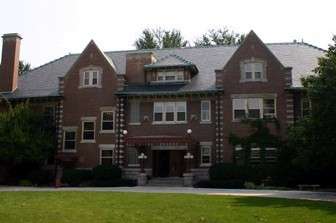 |
(#83004212) |
1821 Sunset Dr. 41°31′44″N 90°30′23″W / 41.528889°N 90.506389°W |
Bettendorf | Twenty-eight room house built by industrialist Joseph W. Bettendorf, one of two brothers for whom the city of Bettendorf is named. It now houses a private school. |
| 2 | Bettendorf-Washington School | Upload image | (#84001317) |
533 16th St. 41°31′41″N 90°30′35″W / 41.528056°N 90.509809°W |
Bettendorf | Former elementary school building that later housed a museum. |
| 3 | James Brown House | .JPG) |
(#82002643) |
424 State St. 41°32′12″N 90°28′12″W / 41.536533°N 90.470135°W |
Riverdale | An 1842 Greek Revival style residence |
| 4 | Alexander Brownlie House | 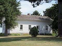 |
(#76000809) |
206 Pine St. 41°42′03″N 90°35′05″W / 41.700833°N 90.584722°W |
Long Grove | Farm house built in 1846. |
| 5 | Buffalo High School | 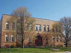 |
(#05000901) |
326 E. 4th St. 41°27′31″N 90°43′16″W / 41.458645°N 90.721158°W |
Buffalo | Former school building and community center that is now a private home. |
| 6 | Cody Homestead | 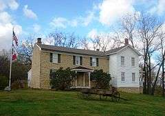 |
(#74000812) |
South of McCausland 41°42′53″N 90°27′17″W / 41.714803°N 90.454720°W |
McCausland | Boyhood home of Buffalo Bill Cody, a government scout and Wild West show performer. |
| 7 | Cody Road Historic District | 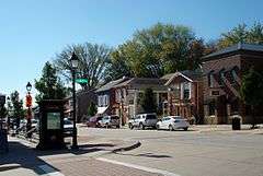 |
(#79000943) |
Irregular pattern along Cody Rd. 41°36′10″N 90°20′38″W / 41.602778°N 90.343889°W |
Le Claire | Cody Road is the main street through Le Claire. It includes the Central Business District. |
| 8 | Community Building | 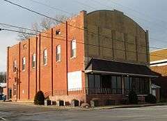 |
(#08000331) |
428 S. River Dr. 41°40′26″N 90°20′26″W / 41.673971°N 90.340419°W |
Princeton | A former commercial building that now houses the Boll's Community Center. |
| 9 | Dawley House | 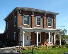 |
(#79003699) |
127 S. 2nd St. 41°35′48″N 90°20′41″W / 41.596667°N 90.344722°W |
Le Claire | An 1851 vernacular Italianate style house that is part of the Houses of Mississippi River Men Thematic Resource. |
| 10 | East Hill House and Carriage House | 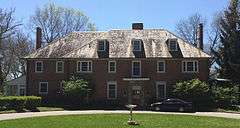 |
(#99001384) |
5004 State St. 41°32′35″N 90°27′42″W / 41.543153°N 90.461597°W |
Riverdale | A 1926 Colonial Revival style residence. |
| 11 | Eldridge Turn-Halle | 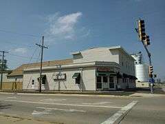 |
(#87000032) |
102 W. LeClaire St. 41°39′18″N 90°35′00″W / 41.654894°N 90.583413°W |
Eldridge | A former Turnverein, it became a commercial building and was destroyed in a fire in 2013. |
| 12 | Forest Grove School No. 5 | 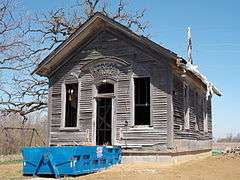 |
(#13000831) |
24040 195th St. 41°35′22″N 90°26′03″W / 41.589414°N 90.434144°W |
Bettendorf vicinity | Former one-room school house near Bettendorf, which was built in 1873. |
| 13 | James Gamble House | 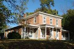 |
(#79003692) |
527 Wisconsin Ave. 41°35′52″N 90°20′57″W / 41.597778°N 90.349167°W |
Le Claire | An 1855 Italianate style residence. |
| 14 | Horton-Suiter House | 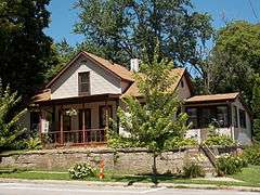 |
(#79003700) |
102 N. 2nd St. 41°35′52″N 90°20′43″W / 41.597742°N 90.345186°W |
Le Claire | A house from 1860 that is part of the Houses of Mississippi River Men Thematic Resource. |
| 15 | Kattenbracher House | 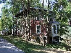 |
(#79003701) |
1125 N. 2nd St. 41°36′36″N 90°20′43″W / 41.610035°N 90.345202°W |
Le Claire | A house from 1860 that is part of the Houses of Mississippi River Men Thematic Resource. |
| 16 | Lock and Dam No. 14 Historic District |  |
(#04000174) |
25549 182nd St. 41°34′28″N 90°24′05″W / 41.574322°N 90.401337°W |
Pleasant Valley Township | Historic District that includes one building, six structures, and two objects. |
| 17 | LONESTAR | 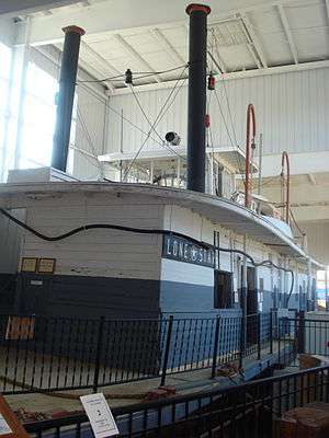 |
(#89002461) |
Buffalo Bill Museum 41°35′54″N 90°20′33″W / 41.598256°N 90.342573°W |
Le Claire | An 1868 wooden, paddlewheel, steam-powered, towboat that is a part of the Buffalo Bill Museum. |
| 18 | McCaffrey House | 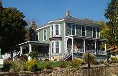 |
(#79003702) |
208 N. Cody Rd. 41°35′56″N 90°20′38″W / 41.598914°N 90.343942°W |
Le Claire | An 1870 vernacular Italianate style house that is part of the Houses of Mississippi River Men Thematic Resource. |
| 19 | Nebergall "Knoll Crest" Round Barn | 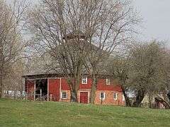 |
(#86001473) |
Telegraph Rd. 41°30′59″N 90°42′54″W / 41.516389°N 90.715°W |
Blue Grass | A round barn that was built by Benton Steele in 1914. |
| 20 | Old Mill House | 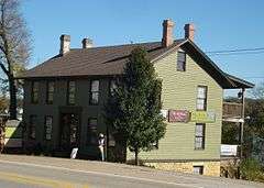 |
(#79003703) |
419 N. Cody Rd. 41°36′06″N 90°20′36″W / 41.601667°N 90.343333°W |
Le Claire | An 1851 Greek Revival style residence that is part of the Houses of Mississippi River Men Thematic Resource. |
| 21 | Rambo House | 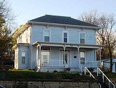 |
(#79003704) |
430 N. Cody Rd. 41°36′06″N 90°20′38″W / 41.601667°N 90.343889°W |
Le Claire | An 1855 Italianate style house that is part of the Houses of Mississippi River Men Thematic Resource. |
| 22 | Regina Coeli Monastery | 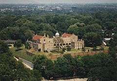 |
(#93001590) |
1401 Central Ave. 41°31′51″N 90°30′45″W / 41.530833°N 90.5125°W |
Bettendorf | A former monastery that was built for Discalced Carmelite nuns. The Romanesque Revival style building became a hotel and now houses an addictions rehabilitation facility. |
| 23 | John Smith House | .JPG) |
(#79003705) |
426 Dodge St. 41°35′47″N 90°20′55″W / 41.596298°N 90.348676°W |
Le Claire | A house built in 1852 that is part of the Houses of Mississippi River Men Thematic Resource. |
| 24 | Roswell Spencer House | Upload image | (#82002642) |
Off U.S. Route 67 41°34′11″N 90°25′24″W / 41.569722°N 90.423333°W |
Pleasant Valley Township | House built in 1850. |
| 25 | Stone House | .jpg) |
(#83002528) |
817 N. 2nd St. 41°36′23″N 90°20′43″W / 41.606342°N 90.345237°W |
Le Claire | |
| 26 | Stone School | Upload image | (#77000558) |
West of Le Claire 41°36′43″N 90°23′55″W / 41.611944°N 90.398611°W |
Le Claire | A one-room school house built of stone along the Territorial Road in rural Scott County. It has subsequently been dimantled. |
| 27 | Jacob Suiter House | 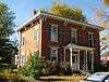 |
(#79003707) |
214 S. 2nd St. 41°35′46″N 90°20′43″W / 41.596078°N 90.345189°W |
Le Claire | A vernacular Italianate style house built in 1860 that is part of the Houses of Mississippi River Men Thematic Resource. |
| 28 | John H. Suiter House |  |
(#79003706) |
1220 N. 2nd St. 41°36′39″N 90°20′45″W / 41.610834°N 90.345769°W |
Le Claire | A house built in 1855 that is part of the Houses of Mississippi River Men Thematic Resource. |
| 29 | William Suiter House |  |
(#79003708) |
227 Wisconsin 41°35′52″N 90°20′46″W / 41.597854°N 90.346058°W |
Le Claire | A house built in 1855 that is part of the Houses of Mississippi River Men Thematic Resource. |
| 30 | George Tromley, Jr., House | 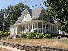 |
(#79003710) |
127 Jones St. 41°35′56″N 90°20′41″W / 41.598761°N 90.344743°W |
Le Claire | A house built in 1865 that is part of the Houses of Mississippi River Men Thematic Resource. |
| 31 | George Tromley, Sr., House | 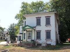 |
(#79003709) |
806 N. Cody Rd. 41°36′22″N 90°20′40″W / 41.606111°N 90.344312°W |
Le Claire | A house built in 1850 that is part of the Houses of Mississippi River Men Thematic Resource. |
| 32 | Samuel Van Sant House |  |
(#79003711) |
322 N. Cody Rd. 41°36′01″N 90°20′38″W / 41.600237°N 90.343885°W |
Le Claire | A house built in 1860 that is part of the Houses of Mississippi River Men Thematic Resource. |
See also
| Wikimedia Commons has media related to National Register of Historic Places in Scott County, Iowa. |
References
- ↑ The latitude and longitude information provided in this table was derived originally from the National Register Information System, which has been found to be fairly accurate for about 99% of listings. For about 1% of NRIS original coordinates, experience has shown that one or both coordinates are typos or otherwise extremely far off; some corrections may have been made. A more subtle problem causes many locations to be off by up to 150 yards, depending on location in the country: most NRIS coordinates were derived from tracing out latitude and longitudes off of USGS topographical quadrant maps created under the North American Datum of 1927, which differs from the current, highly accurate WGS84 GPS system used by most on-line maps. Chicago is about right, but NRIS longitudes in Washington are higher by about 4.5 seconds, and are lower by about 2.0 seconds in Maine. Latitudes differ by about 1.0 second in Florida. Some locations in this table may have been corrected to current GPS standards.
- ↑ "National Register of Historic Places: Weekly List Actions". National Park Service, United States Department of the Interior. Retrieved on December 16, 2016.
- ↑ Numbers represent an ordering by significant words. Various colorings, defined here, differentiate National Historic Landmarks and historic districts from other NRHP buildings, structures, sites or objects.
- ↑ National Park Service (2008-04-24). "National Register Information System". National Register of Historic Places. National Park Service.
- ↑ The eight-digit number below each date is the number assigned to each location in the National Register Information System database, which can be viewed by clicking the number.
| Topics | |
|---|---|
| Lists by states |
|
| Lists by insular areas | |
| Lists by associated states | |
| Other areas | |
| |

| Bettendorf | | |
|---|---|---|
| Blue Grass / Buffalo | ||
| Davenport | ||
| Eldridge | ||
| Le Claire |
| |
| Long Grove | ||
| McCausland | ||
| Pleasant Valley | ||
| Princeton | ||
| Riverdale | ||
This article is issued from Wikipedia - version of the 11/4/2016. The text is available under the Creative Commons Attribution/Share Alike but additional terms may apply for the media files.