| [3] |
Name on the Register[4] |
Image |
Date listed[5] |
Location |
City or town |
Description |
|---|
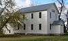
| 1 |
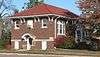
Bon Homme County Courthouse |
|
000000001984-12-13-0000December 13, 1984
(#84000581) |
300 W. 18th Ave.[6]
42°59′38″N 97°51′58″W / 42.993860°N 97.866150°W / 42.993860; -97.866150 (Bon Homme County Courthouse) |
Tyndall |
|
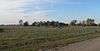
| 2 |
Bon Homme Hutterite Colony |
|
000000001982-06-30-0000June 30, 1982
(#82003913) |
On the Missouri River
42°51′46″N 97°42′23″W / 42.862778°N 97.706389°W / 42.862778; -97.706389 (Bon Homme Hutterite Colony) |
Tabor |
|
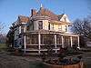
| 3 |
Gen. Charles T. Campbell House |
Upload image |
000000001982-06-17-0000June 17, 1982
(#82003911) |
611 4th St.
43°08′26″N 97°42′58″W / 43.140556°N 97.716111°W / 43.140556; -97.716111 (Gen. Charles T. Campbell House) |
Scotland |
|
| 4 |
Carnegie Public Library of Tyndall |
|
000000001984-12-13-0000December 13, 1984
(#84000582) |
110 W. 17th Ave.[7]
42°59′33″N 97°51′50″W / 42.992494°N 97.863756°W / 42.992494; -97.863756 (Carnegie Public Library of Tyndall) |
Tyndall |
|
| 5 |
Cihak Farmstead |
Upload image |
000000001984-11-28-0000November 28, 1984
(#84001263) |
Southeastern corner of the southwestern quadrant of Section 2, T69N, R60W[8]
Coordinates missing |
Scotland |
|
| 6 |
John Frydrych Farmstead |
|
000000001987-07-06-0000July 6, 1987
(#87001053) |
Northern side of Highway 50
42°58′41″N 97°46′37″W / 42.978091°N 97.776897°W / 42.978091; -97.776897 (John Frydrych Farmstead) |
Tyndall |
|
| 7 |
Dr. John C. Greenfield House |
|
000000001989-10-19-0000October 19, 1989
(#89001717) |
307 W. 1st St.
43°00′19″N 98°03′46″W / 43.005278°N 98.062778°W / 43.005278; -98.062778 (Dr. John C. Greenfield House) |
Avon |
|
| 8 |
John Hakl Chalkrock House |
Upload image |
000000001987-06-07-0000June 7, 1987
(#87001050) |
Southwest of Tabor off Highway 50
42°56′22″N 97°41′34″W / 42.939444°N 97.692778°W / 42.939444; -97.692778 (John Hakl Chalkrock House) |
Tabor |
|
| 9 |
Joseph Herman Chalkrock House |
Upload image |
000000001987-07-06-0000July 6, 1987
(#87001045) |
Western side of Highway 25
42°58′02″N 97°43′13″W / 42.967222°N 97.720278°W / 42.967222; -97.720278 (Joseph Herman Chalkrock House) |
Tabor |
|
| 10 |
Joseph Herman Log Stable |
Upload image |
000000001987-07-06-0000July 6, 1987
(#87001047) |
Western side of Highway 25
42°58′03″N 97°43′14″W / 42.9675°N 97.720556°W / 42.9675; -97.720556 (Joseph Herman Log Stable) |
Tabor |
|
| 11 |
Joseph Herman Rubblestone Barn |
Upload image |
000000001987-07-06-0000July 6, 1987
(#87001046) |
Western side of Highway 25
42°58′03″N 97°43′11″W / 42.9675°N 97.719722°W / 42.9675; -97.719722 (Joseph Herman Rubblestone Barn) |
Tabor |
|
| 12 |
Martin Honner Chalkrock House |
Upload image |
000000001987-07-06-0000July 6, 1987
(#87001052) |
Northwest of Tabor off Highway 50
42°57′15″N 97°40′37″W / 42.954167°N 97.676944°W / 42.954167; -97.676944 (Martin Honner Chalkrock House) |
Tabor |
|
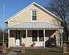
| 13 |
Koobs House |
|
000000001984-08-01-0000August 1, 1984
(#84003218) |
631 4th St.[9]
43°08′56″N 97°42′57″W / 43.148895°N 97.715847°W / 43.148895; -97.715847 (Koobs House) |
Scotland |
|
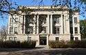
| 14 |
Main Hall |
Upload image |
000000001981-02-03-0000February 3, 1981
(#81000572) |
Former University of South Dakota - Springfield campus
42°51′32″N 97°53′50″W / 42.858889°N 97.897222°W / 42.858889; -97.897222 (Main Hall) |
Springfield |
|
| 15 |
John and Kate Merkwan Log and Rubblestone House |
Upload image |
000000001987-07-06-0000July 6, 1987
(#87001041) |
Eastern side of Highway 25
43°00′24″N 97°42′31″W / 43.006667°N 97.708611°W / 43.006667; -97.708611 (John and Kate Merkwan Log and Rubblestone House) |
Tabor |
|
| 16 |
John and Kate Merkwan Rubblestone House-Barn |
Upload image |
000000001987-07-06-0000July 6, 1987
(#87001040) |
Eastern side of Highway 25
43°00′24″N 97°42′33″W / 43.006667°N 97.709167°W / 43.006667; -97.709167 (John and Kate Merkwan Rubblestone House-Barn) |
Tabor |
|
| 17 |
John Merkwan, Jr. Rubblestone House |
Upload image |
000000001987-07-06-0000July 6, 1987
(#87001044) |
Western side of Highway 25
43°00′16″N 97°42′59″W / 43.004444°N 97.716389°W / 43.004444; -97.716389 (John Merkwan, Jr. Rubblestone House) |
Tabor |
|
| 18 |
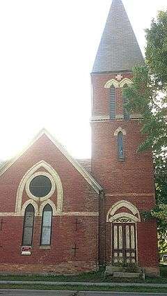
Methodist Episcopal Church |
|
000000001979-09-12-0000September 12, 1979
(#79002397) |
811 6th St.
43°08′51″N 97°42′48″W / 43.147508°N 97.713206°W / 43.147508; -97.713206 (Methodist Episcopal Church) |
Scotland |
|
| 19 |
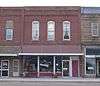
William Metzgers New Emporium |
|
000000002001-10-07-0000October 7, 2001
(#01001079) |
1610 Main St.
42°59′30″N 97°51′46″W / 42.991711°N 97.862872°W / 42.991711; -97.862872 (William Metzgers New Emporium) |
Tyndall |
|
| 20 |
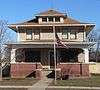
Peter and Minnie Monfore House |
|
000000002002-10-31-0000October 31, 2002
(#02001287) |
612 12th St.
42°51′32″N 97°53′38″W / 42.858889°N 97.893889°W / 42.858889; -97.893889 (Peter and Minnie Monfore House) |
Springfield |
|
| 21 |
Joseph Noll Chalkrock Barn |
Upload image |
000000001987-07-06-0000July 6, 1987
(#87001049) |
South of Tabor off Highway 50
42°56′12″N 97°39′48″W / 42.936667°N 97.663333°W / 42.936667; -97.663333 (Joseph Noll Chalkrock Barn) |
Tabor |
|
| 22 |
Old St. Wenceslaus Catholic Parish House |
|
000000001988-02-08-0000February 8, 1988
(#88000023) |
227 Yankton St.
42°56′59″N 97°39′28″W / 42.949852°N 97.657787°W / 42.949852; -97.657787 (Old St. Wenceslaus Catholic Parish House) |
Tabor |
|
| 23 |
St. Andrew's Episcopal Church |
|
000000001982-06-17-0000June 17, 1982
(#82003912) |
4th and Poplar Sts.
43°08′30″N 97°42′59″W / 43.141667°N 97.716389°W / 43.141667; -97.716389 (St. Andrew's Episcopal Church) |
Scotland |
|
| 24 |
St. Wenceslaus Catholic Church and Parish House |
|
000000001984-12-13-0000December 13, 1984
(#84000579) |
Yankton and Lidice Sts.
42°57′02″N 97°39′31″W / 42.950462°N 97.658516°W / 42.950462; -97.658516 (St. Wenceslaus Catholic Church and Parish House) |
Tabor |
|
| 25 |
Scotland Main Street Historic District |
|
000000001999-12-09-0000December 9, 1999
(#99001429) |
Along Main St., roughly bounded by Railway, Poplar, 3rd, and Juniper Sts.
43°08′58″N 97°43′05″W / 43.149444°N 97.718056°W / 43.149444; -97.718056 (Scotland Main Street Historic District) |
Scotland |
|
| 26 |
Scotland Residential Historic District |
|
000000001995-12-13-0000December 13, 1995
(#95001439) |
Roughly bounded by Chestnut, 5th, Juniper and 3rd Sts.
43°09′04″N 97°42′57″W / 43.151111°N 97.715833°W / 43.151111; -97.715833 (Scotland Residential Historic District) |
Scotland |
|
| 27 |
Scotland Royal Theater |
Upload image |
000000001996-10-31-0000October 31, 1996
(#96001224) |
565 Main St.
43°08′58″N 97°43′09″W / 43.149444°N 97.719167°W / 43.149444; -97.719167 (Scotland Royal Theater) |
Scotland |
|
| 28 |
Jacob Sedlacek Chalkrock House |
Upload image |
000000001987-07-06-0000July 6, 1987
(#87001051) |
Southwest of Tabor off Highway 50
42°56′06″N 97°41′28″W / 42.935°N 97.691111°W / 42.935; -97.691111 (Jacob Sedlacek Chalkrock House) |
Tabor |
|
| 29 |
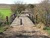
South Dakota Dept. of Transportation Bridge No. 05-028-200 |
|
000000001993-12-09-0000December 9, 1993
(#93001270) |
Local road over Choteau Creek
42°52′48″N 98°06′49″W / 42.880138°N 98.113736°W / 42.880138; -98.113736 (South Dakota Dept. of Transportation Bridge No. 05-028-200) |
Perkins |
|
| 30 |
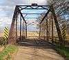
South Dakota Dept. of Transportation Bridge No. 05-032-170 |
|
000000001993-12-09-0000December 9, 1993
(#93001271) |
Local road over Choteau Creek
42°55′24″N 98°06′23″W / 42.923439°N 98.106478°W / 42.923439; -98.106478 (South Dakota Dept. of Transportation Bridge No. 05-032-170) |
Avon |
|
| 31 |
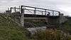
South Dakota Dept. of Transportation Bridge No. 05-138-080 |
|
000000001993-12-09-0000December 9, 1993
(#93001272) |
299 Street west of 415 Avenue[10]
43°03′13″N 97°53′40″W / 43.053583°N 97.894473°W / 43.053583; -97.894473 (South Dakota Dept. of Transportation Bridge No. 05-138-080) |
Tyndall |
|
| 32 |
South Dakota Dept. of Transportation Bridge No. 05-255-130 |
Upload image |
000000001993-12-09-0000December 9, 1993
(#93001273) |
Local road over Beaver Creek
42°58′52″N 97°39′53″W / 42.981111°N 97.664722°W / 42.981111; -97.664722 (South Dakota Dept. of Transportation Bridge No. 05-255-130) |
Tabor |
|
| 33 |
Tabor School |
|
000000001983-09-02-0000September 2, 1983
(#83003001) |
Vancura Memorial Park
42°56′54″N 97°39′31″W / 42.948219°N 97.658690°W / 42.948219; -97.658690 (Tabor School) |
Tabor |
|
| 34 |
Teibel-Sykora Rubblestone Barn |
Upload image |
000000001987-07-06-0000July 6, 1987
(#87001048) |
Western side of Highway 25
43°01′17″N 97°43′16″W / 43.021389°N 97.721111°W / 43.021389; -97.721111 (Teibel-Sykora Rubblestone Barn) |
Tabor |
|
| 35 |
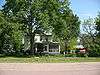
Thompson House |
|
000000002003-10-23-0000October 23, 2003
(#03001076) |
30985 421st. Ave.
42°53′44″N 97°46′26″W / 42.895677°N 97.773926°W / 42.895677; -97.773926 (Thompson House) |
Springfield |
|
| 36 |
John Travnicek Chalkrock House |
Upload image |
000000001987-07-06-0000July 6, 1987
(#87001043) |
Western side of junction of Highway 50 and Highway 25
42°57′46″N 97°42′55″W / 42.962778°N 97.715278°W / 42.962778; -97.715278 (John Travnicek Chalkrock House) |
Tabor |
|
| 37 |
Joseph V. Wagner House |
|
000000002001-06-06-0000June 6, 2001
(#01000633) |
112 Lidice St.
42°56′56″N 97°39′33″W / 42.948922°N 97.659299°W / 42.948922; -97.659299 (Joseph V. Wagner House) |
Tabor |
|
| 38 |
Albion Walker Chalkrock House |
Upload image |
000000001987-07-06-0000July 6, 1987
(#87001042) |
South of Highway 52
42°54′10″N 97°39′36″W / 42.902778°N 97.66°W / 42.902778; -97.66 (Albion Walker Chalkrock House) |
Tabor |
|
| 39 |
ZCBJ Hall |
|
000000001985-01-31-0000January 31, 1985
(#85000181) |
1910 Ivy Street[11]
42°59′44″N 97°51′57″W / 42.995572°N 97.865756°W / 42.995572; -97.865756 (ZCBJ Hall) |
Tyndall |
|
.jpg)
_from_W_1.JPG)
_from_N_1.JPG)
_from_SE_1.jpg)
_from_WNW_1.JPG)
_from_SE_1.JPG)
_from_S_1.JPG)