National Register of Historic Places listings in Greenwood County, Kansas
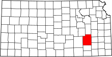
Location of Greenwood County in Kansas
This is a list of the National Register of Historic Places listings in Greenwood County, Kansas.
This is intended to be a complete list of the properties on the National Register of Historic Places in Greenwood County, Kansas, United States. The locations of National Register properties for which the latitude and longitude coordinates are included below, may be seen in a map.[1]
There are 14 properties listed on the National Register in the county.
- This National Park Service list is complete through NPS recent listings posted December 16, 2016.[2]
Current listings
| [3] | Name on the Register[4] | Image | Date listed[5] | Location | City or town | Description |
|---|---|---|---|---|---|---|
| 1 | Archeological Site Number 14GR320 | Upload image | (#82004880) |
Address restricted |
Fall River State Park | |
| 2 | Curry Archeological Site | Upload image | (#74000838) |
Address restricted |
Madison | |
| 3 | Eureka Atchison, Topeka and Santa Fe Railroad Depot | 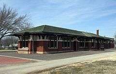 |
(#12001119) |
416 E. 5th St. 37°49′25″N 96°17′21″W / 37.82361°N 96.28916°W |
Eureka | |
| 4 | Eureka Carnegie Library | Upload image | (#88001170) |
520 N. Main 37°49′29″N 96°17′23″W / 37.824722°N 96.289722°W |
Eureka | |
| 5 | Greenwood Hotel | 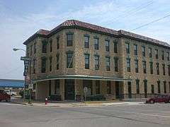 |
(#06000769) |
300 N. Main 37°49′17″N 96°17′36″W / 37.821389°N 96.293333°W |
Eureka | |
| 6 | Paul Jones Building | Upload image | (#12000247) |
319 W. River St. 37°49′04″N 96°17′49″W / 37.817836°N 96.297078°W |
Eureka | part of the Roadside Kansas Multiple Property Submission (MPS) |
| 7 | Lone Cone Site | Upload image | (#76000822) |
Address restricted |
Madison | |
| 8 | Madison Atchison, Topeka and Santa Fe Railroad Depot | Upload image | (#91001774) |
Junction of 3rd and Boone Sts. 38°08′23″N 96°08′07″W / 38.139722°N 96.135278°W |
Madison | |
| 9 | North Branch Otter Creek Bridge | Upload image | (#85001426) |
1 mile (1.6 km) west and 5 miles (8.0 km) north of Piedmont 37°41′28″N 96°22′46″W / 37.691111°N 96.379444°W |
Piedmont | |
| 10 | Robertson House | 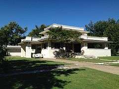 |
(#10001207) |
403 N. Plum 37°41′28″N 96°22′46″W / 37.691111°N 96.379444°W |
Eureka | |
| 11 | Two Duck Site | Upload image | (#75000713) |
Address restricted |
Severy | |
| 12 | US Post Office-Eureka | Upload image | (#89001637) |
301 N. Oak St. 37°49′20″N 96°17′51″W / 37.822222°N 96.2975°W |
Eureka | |
| 13 | Verdigris River Bridge | Upload image | (#85001444) |
0.5 miles (0.80 km) north of Madison 38°08′46″N 96°08′19″W / 38.146111°N 96.138611°W |
Madison | |
| 14 | Westside Service Station and Riverside Motel | Upload image | (#12000248) |
325 W. River St. 37°49′04″N 96°17′50″W / 37.817819°N 96.297174°W |
Eureka | part of the Roadside Kansas MPS |
See also
| Wikimedia Commons has media related to National Register of Historic Places in Greenwood County, Kansas. |
- List of National Historic Landmarks in Kansas
- National Register of Historic Places listings in Kansas
References
- ↑ The latitude and longitude information provided in this table was derived originally from the National Register Information System, which has been found to be fairly accurate for about 99% of listings. For about 1% of NRIS original coordinates, experience has shown that one or both coordinates are typos or otherwise extremely far off; some corrections may have been made. A more subtle problem causes many locations to be off by up to 150 yards, depending on location in the country: most NRIS coordinates were derived from tracing out latitude and longitudes off of USGS topographical quadrant maps created under the North American Datum of 1927, which differs from the current, highly accurate WGS84 GPS system used by most on-line maps. Chicago is about right, but NRIS longitudes in Washington are higher by about 4.5 seconds, and are lower by about 2.0 seconds in Maine. Latitudes differ by about 1.0 second in Florida. Some locations in this table may have been corrected to current GPS standards.
- ↑ "National Register of Historic Places: Weekly List Actions". National Park Service, United States Department of the Interior. Retrieved on December 16, 2016.
- ↑ Numbers represent an ordering by significant words. Various colorings, defined here, differentiate National Historic Landmarks and historic districts from other NRHP buildings, structures, sites or objects.
- ↑ National Park Service (2009-03-13). "National Register Information System". National Register of Historic Places. National Park Service.
- ↑ The eight-digit number below each date is the number assigned to each location in the National Register Information System database, which can be viewed by clicking the number.

Municipalities and communities of Greenwood County, Kansas, United States | ||
|---|---|---|
| Cities | | |
| Unincorporated communities | ||
| Ghost towns | ||
| Townships | ||
This article is issued from Wikipedia - version of the 4/3/2016. The text is available under the Creative Commons Attribution/Share Alike but additional terms may apply for the media files.