National Register of Historic Places listings in Wilson County, Kansas
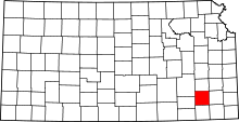
Location of Wilson County in Kansas
This is a list of the National Register of Historic Places listings in Wilson County, Kansas. It is intended to be a complete list of the properties and districts on the National Register of Historic Places in Wilson County, Kansas, United States. The locations of National Register properties and districts for which the latitude and longitude coordinates are included below, may be seen in an online map.
There are 7 properties and districts listed on the National Register in the county.
- This National Park Service list is complete through NPS recent listings posted December 16, 2016.[1]
Current listings
| [2] | Name on the Register[3] | Image | Date listed[4] | Location | City or town | Description |
|---|---|---|---|---|---|---|
| 1 | Brown Hotel | Upload image | (#95000863) |
523 Main St. 37°25′03″N 95°40′50″W / 37.4175°N 95.680556°W |
Neodesha | Boundary increase, 519-523 Main St. (#08000690), listed on 3 July 2008 |
| 2 | Brush Creek Bridge | Upload image | (#85001419) |
½ mile south of Coyville 37°40′41″N 95°53′48″W / 37.678056°N 95.896667°W |
Coyville | |
| 3 | Dr. A. C. Flack House | Upload image | (#89001463) |
303 N. 8th St. 37°32′02″N 95°49′35″W / 37.533889°N 95.826389°W |
Fredonia | |
| 4 | Gold Dust Hotel | Upload image | (#91001542) |
402 N. 7th St. 37°32′02″N 95°49′33″W / 37.533889°N 95.825833°W |
Fredonia | |
| 5 | Norman No. 1 Oil Well Site | 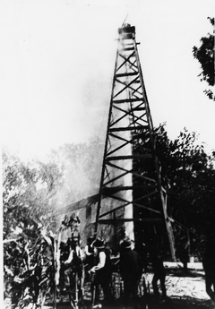 |
(#74000846) |
E. Mill St. 37°24′45″N 95°37′40″W / 37.4125°N 95.627778°W |
Neodesha | |
| 6 | US Post Office-Fredonia | Upload image | (#89001638) |
428 Madison St. 37°32′05″N 95°49′53″W / 37.534722°N 95.831389°W |
Fredonia | |
| 7 | US Post Office-Neodesha | Upload image | (#89001647) |
123 N. 5th St. 37°25′00″N 95°40′53″W / 37.416667°N 95.681389°W |
Neodesha |
See also
- List of National Historic Landmarks in Kansas
- National Register of Historic Places listings in Kansas
References
- ↑ "National Register of Historic Places: Weekly List Actions". National Park Service, United States Department of the Interior. Retrieved on December 16, 2016.
- ↑ Numbers represent an ordering by significant words. Various colorings, defined here, differentiate National Historic Landmarks and historic districts from other NRHP buildings, structures, sites or objects.
- ↑ National Park Service (2010-07-09). "National Register Information System". National Register of Historic Places. National Park Service.
- ↑ The eight-digit number below each date is the number assigned to each location in the National Register Information System database, which can be viewed by clicking the number.
External links
| Wikimedia Commons has media related to National Register of Historic Places in Wilson County, Kansas. |

| Topics | |
|---|---|
| Lists by states |
|
| Lists by insular areas | |
| Lists by associated states | |
| Other areas | |
| |
Municipalities and communities of Wilson County, Kansas, United States | ||
|---|---|---|
| Cities | | |
| Unincorporated communities | ||
| Townships | ||
This article is issued from Wikipedia - version of the 4/3/2016. The text is available under the Creative Commons Attribution/Share Alike but additional terms may apply for the media files.