National Register of Historic Places listings in Marion County, Kansas
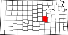
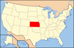
Location of Marion County in Kansas
This is a list of the National Register of Historic Places listings in Marion County, Kansas.
This is intended to be a complete list of the properties and districts on the National Register of Historic Places in Marion County, Kansas, United States. The locations of National Register properties and districts for which the latitude and longitude coordinates are included below, may be seen in a map.[1]
There are 29 properties and districts listed on the National Register in the county.
- This National Park Service list is complete through NPS recent listings posted December 16, 2016.[2]
Current listings
| [3] | Name on the Register[4] | Image | Date listed[5] | Location | City or town | Description |
|---|---|---|---|---|---|---|
| 1 | 1927 Hillsboro Water Tower | Upload image | (#11000727) |
Lots 10 & 11, Block 2, Hill's 2nd Addition 38°21′15″N 97°12′25″W / 38.354167°N 97.206944°W |
Hillsboro | |
| 2 | Amelia Park Bridge | Upload image | (#03001467) |
0.5 miles west of U.S. Route 77 on 260th Street (approximate 1 mile north-east of Antelope) 38°26′47″N 96°57′58″W / 38.446389°N 96.966111°W |
Antelope | |
| 3 | Bethel School | Upload image | (#87002114) |
5.25 miles east of Lincolnville on 290th Street 38°29′37″N 96°51′38″W / 38.493611°N 96.860556°W |
Lincolnville | |
| 4 | Bichet School, District 34 | 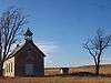 |
(#03001498) |
4.5 miles east of Florence on U.S. Route 50, then 0.1 mile north on Bluestem Road 38°15′08″N 96°50′53″W / 38.252222°N 96.848056°W |
Florence | |
| 5 | Bown-Corby School | Upload image | (#15000146) |
412 N. 2nd St. 38°21′04″N 97°01′17″W / 38.3510°N 97.0213°W |
Marion | |
| 6 | Burns Union School | 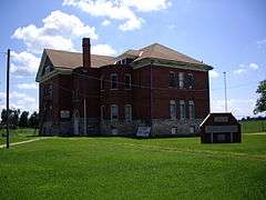 |
(#75000714) |
Southwest corner of Ohio and Main Streets 38°05′20″N 96°53′14″W / 38.088889°N 96.887222°W |
Burns | Currently the Burns Community Museum.[6] |
| 7 | Donahue's Santa Fe Trail Segment | Upload image | (#16000705) |
Address Restricted |
Durham vicinity | |
| 8 | Doyle Place | Upload image | (#98000266) |
0.3 mile south of Florence railroad track on Main Street 38°14′04″N 96°55′33″W / 38.234444°N 96.925833°W |
Florence | |
| 9 | Elgin Hotel | Upload image | (#78001286) |
115 North 3rd Street 38°20′56″N 97°01′11″W / 38.348889°N 97.019722°W |
Marion | |
| 10 | Florence Opera House | Upload image | (#10001142) |
Southwest corner of 5th and Main Streets 38°14′32″N 96°55′36″W / 38.242222°N 96.926667°W |
Florence | |
| 11 | Florence Water Tower | Upload image | (#09000275) |
525 West 5th Street 38°14′31″N 96°56′02″W / 38.242042°N 96.933819°W |
Florence | |
| 12 | French Frank's Santa Fe Trail Segment | Upload image | (#13000131) |
Address Restricted |
Lehigh vicinity | |
| 13 | Harvey House | Upload image | (#73000763) |
221 North Marion Street 38°14′24″N 96°55′41″W / 38.24°N 96.928056°W |
Florence | See Fred Harvey Company.[7] |
| 14 | Hill Grade School | Upload image | (#76000827) |
601 East Main Street 38°20′54″N 97°00′54″W / 38.348333°N 97.015°W |
Marion | |
| 15 | Island Field Ranch House | Upload image | (#95000579) |
3.5 miles south of Lincolnville on U.S. Route 77 (1 mile east of Antelope) 38°26′13″N 96°57′28″W / 38.436944°N 96.957778°W |
Lincolnville | |
| 16 | Lost Springs | Upload image | (#76000826) |
2.5 miles west of Lost Springs on 340th Street 38°34′00″N 97°00′46″W / 38.566667°N 97.012778°W |
Lost Springs | |
| 17 | Marion Archeological District | Upload image | (#76000829) |
Various locations along Mud Creek and the Cottonwood River[8] 38°21′54″N 97°01′06″W / 38.365000°N 97.018333°W |
Marion | |
| 18 | Marion County Courthouse | 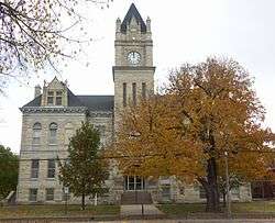 |
(#76000828) |
200 South 3rd Street 38°20′50″N 97°01′09″W / 38.347222°N 97.019167°W |
Marion | |
| 19 | Marion County Park and Lake | Upload image | (#02000607) |
1 mile east of Marion on 190th Street (Main), then 1.75 miles south on Upland Road 38°19′14″N 96°58′59″W / 38.320556°N 96.983056°W |
Marion | |
| 20 | P.H. Meehan House | Upload image | (#07001227) |
401 North Columbus Street 38°32′54″N 97°09′22″W / 38.548333°N 97.156111°W |
Tampa | |
| 21 | W.H. Morgan House | 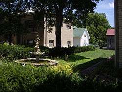 |
(#95001562) |
212 North Walnut Street 38°10′01″N 97°06′23″W / 38.166944°N 97.106389°W |
Peabody | |
| 22 | Old Peabody Library | 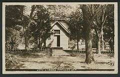 |
(#73000765) |
106 East Division Avenue 38°10′02″N 97°06′22″W / 38.167222°N 97.106111°W |
Peabody | Currently the Peabody Historical Museum.[9] |
| 23 | Peabody City Park | 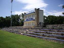 |
(#11001032) |
W. 2nd and Locust Sts. 38°09′58″N 97°06′45″W / 38.166161°N 97.112378°W |
Peabody | |
| 24 | Peabody Downtown Historic District | 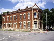 |
(#98000590) |
Walnut Street area, between Division and First Streets 38°09′57″N 97°06′25″W / 38.165833°N 97.106944°W |
Peabody | |
| 25 | Peabody Township Carnegie Library | 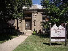 |
(#87000959) |
214 North Walnut Street 38°10′02″N 97°06′24″W / 38.167222°N 97.106667°W |
Peabody | Currently the Peabody Township Library.[10] |
| 26 | Pioneer Adobe House | Upload image | (#73000764) |
501 South Ash Street 38°20′51″N 97°12′23″W / 38.3475°N 97.206389°W |
Hillsboro | Currently the Peter Paul Loewen House.[11] |
| 27 | Santa Fe Trail - Marion County Trail Segments | Upload image | (#95000584) |
From corner of 270th St and Falcon Rd, parallels on west side of railroad tracks towards southwest 38°27′26″N 97°16′39″W / 38.457222°N 97.2775°W |
Durham | |
| 28 | William F. and Ida G. Schaeffler House | Upload image | (#02000490) |
312 East Grand Avenue 38°21′15″N 97°12′02″W / 38.354167°N 97.200556°W |
Hillsboro | Currently the William F. Schaeffler House Museum.[12] |
| 29 | J.S. Schroeder Building | Upload image | (#91001770) |
111 North Walnut Street 38°09′54″N 97°06′13″W / 38.165°N 97.103611°W |
Peabody |
See also
| Wikimedia Commons has media related to National Register of Historic Places in Marion County, Kansas. |
- List of National Historic Landmarks in Kansas
- National Register of Historic Places listings in Kansas
References
- ↑ The latitude and longitude information provided in this table was derived originally from the National Register Information System, which has been found to be fairly accurate for about 99% of listings. For about 1% of NRIS original coordinates, experience has shown that one or both coordinates are typos or otherwise extremely far off; some corrections may have been made. A more subtle problem causes many locations to be off by up to 150 yards, depending on location in the country: most NRIS coordinates were derived from tracing out latitude and longitudes off of USGS topographical quadrant maps created under the North American Datum of 1927, which differs from the current, highly accurate WGS84 GPS system used by most on-line maps. Chicago is about right, but NRIS longitudes in Washington are higher by about 4.5 seconds, and are lower by about 2.0 seconds in Maine. Latitudes differ by about 1.0 second in Florida. Some locations in this table may have been corrected to current GPS standards.
- ↑ "National Register of Historic Places: Weekly List Actions". National Park Service, United States Department of the Interior. Retrieved on December 16, 2016.
- ↑ Numbers represent an ordering by significant words. Various colorings, defined here, differentiate National Historic Landmarks and historic districts from other NRHP buildings, structures, sites or objects.
- ↑ National Park Service (2008-04-24). "National Register Information System". National Register of Historic Places. National Park Service.
- ↑ The eight-digit number below each date is the number assigned to each location in the National Register Information System database, which can be viewed by clicking the number.
- ↑ Burns Union School - Official Website
- ↑ Harvey House - Official Website
- ↑ Roper, Donna C. "The Marion Great Bend Aspect Sites: Floodplain Settlement on the Plains". Plains Anthropologist 47.180 (2002): 17-32: 18.
- ↑ Old Peabody Library - Website
- ↑ Peabody Township Carnegie Library - Official Website
- ↑ Pioneer Adobe House - Official Website
- ↑ W.F. Schaeffler House - Official Website

Municipalities and communities of Marion County, Kansas, United States | ||
|---|---|---|
| Cities | | |
| Unincorporated communities | ||
| Ghost towns | ||
| Townships | ||
| Footnotes | ‡This populated place also has portions in an adjacent county or counties | |
This article is issued from Wikipedia - version of the 10/23/2016. The text is available under the Creative Commons Attribution/Share Alike but additional terms may apply for the media files.