| [3] |
Name on the Register |
Image |
Date listed[4] |
Location |
Description |
|---|
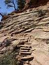
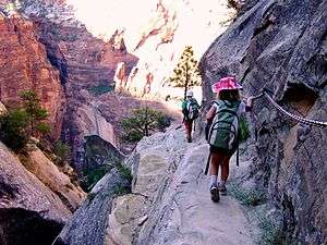
| 1 |
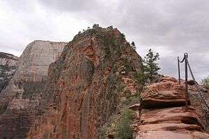
Angels Landing Trail-West Rim Trail |
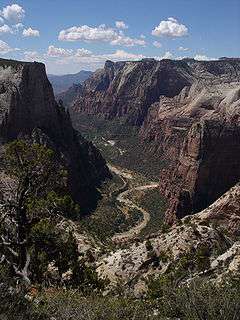
|
000000001987-02-14-0000February 14, 1987
(#86003707) |
South of Scout Lookout across the Virgin River and Refrigerator Canyon
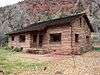
37°16′06″N 112°56′58″W / 37.268333°N 112.949444°W / 37.268333; -112.949444 (Angels Landing Trail-West Rim Trail) |
|
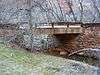
| 2 |
Cable Creek Bridge |
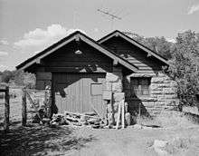
|
000000001996-02-16-0000February 16, 1996
(#96000053) |
Floor of the Valley Rd. at milepost 4.48, south of Weeping Rock Parking Area entrance
37°16′13″N 112°56′19″W / 37.270278°N 112.938611°W / 37.270278; -112.938611 (Cable Creek Bridge) |
|
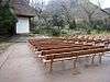
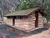
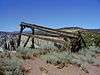
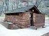
| 3 |
Cable Mountain Draw Works |
|
000000001978-05-24-0000May 24, 1978
(#78000281) |
North of Springdale in Zion National Park
37°15′57″N 112°55′59″W / 37.265833°N 112.933056°W / 37.265833; -112.933056 (Cable Mountain Draw Works) |
|
| 4 |
Canyon Overlook Trail |
|
000000001987-02-14-0000February 14, 1987
(#86003722) |
Across the highway from the parking area at the eastern end of the Zion-Mt. Carmel Tunnel to a point directly above the Great Arch of Zion
37°12′49″N 112°56′54″W / 37.213611°N 112.948333°W / 37.213611; -112.948333 (Canyon Overlook Trail) |
|
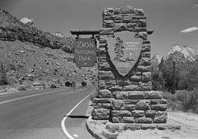
| 5 |
East Entrance Checking Station |
|
000000001987-02-14-0000February 14, 1987
(#86003711) |
Island in middle of State Route 9
37°14′01″N 112°52′06″W / 37.233611°N 112.868333°W / 37.233611; -112.868333 (East Entrance Checking Station) |
|
| 6 |
East Entrance Residence |
|
000000001987-02-14-0000February 14, 1987
(#86003712) |
Eastern entrance 150 feet north of State Route 9
37°14′01″N 112°52′41″W / 37.233611°N 112.878056°W / 37.233611; -112.878056 (East Entrance Residence) |
|
| 7 |
East Entrance Sign |
|
000000001987-07-07-0000July 7, 1987
(#86003710) |
East Entrance Checking Station on northern and southern sides of State Route 9
37°14′07″N 112°52′07″W / 37.235278°N 112.868611°W / 37.235278; -112.868611 (East Entrance Sign) |
|
| 8 |
East Rim Trail |
|
000000001987-07-07-0000July 7, 1987
(#86003723) |
Between Weeping Rock Parking Area and Observation Point
37°16′42″N 112°55′45″W / 37.278333°N 112.929167°W / 37.278333; -112.929167 (East Rim Trail) |
|
| 9 |
Emerald Pools Trail |
|
000000001987-02-14-0000February 14, 1987
(#86003725) |
Footbridge across the highway from Utah Parks Lodge proceeding west to the Lower Emerald Pool
37°14′58″N 112°57′16″W / 37.249444°N 112.954444°W / 37.249444; -112.954444 (Emerald Pools Trail) |
|
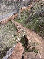
| 10 |
Flanigan Ditch |
|
000000001998-01-12-0000January 12, 1998
(#97001630) |
Zion National Park
37°12′53″N 112°58′28″W / 37.214722°N 112.974444°W / 37.214722; -112.974444 (Flanigan Ditch) |
|
| 11 |
Floor of the Valley Road |
|
000000001996-02-16-0000February 16, 1996
(#96000048) |
From its junction with the Zion-Mt. Carmel Highway along the North Fork of the Virgin River in Zion National Park
37°15′20″N 112°57′17″W / 37.255556°N 112.954722°W / 37.255556; -112.954722 (Floor of the Valley Road) |
|
| 12 |
Gateway to the Narrows Trail |
|
000000001987-07-07-0000July 7, 1987
(#86003726) |
Temple of Sinawava at the end of Zion Canyon Scenic Dr. to a point 1 mile north on the Virgin River
37°17′48″N 112°56′42″W / 37.296667°N 112.945°W / 37.296667; -112.945 (Gateway to the Narrows Trail) |
|
| 13 |
Grotto Camping Ground North Comfort Station |
|
000000001987-02-14-0000February 14, 1987
(#86003705) |
Grotto Picnic Area near Grotto Residence, east of Scenic Dr.
37°15′33″N 112°56′33″W / 37.259167°N 112.9425°W / 37.259167; -112.9425 (Grotto Camping Ground North Comfort Station) |
|
| 14 |
Grotto Camping Ground South Comfort Station |
|
000000001987-02-14-0000February 14, 1987
(#86003704) |
Grotto Picnic Area near Grotto Residence, east of Scenic Dr.
37°15′31″N 112°56′27″W / 37.258611°N 112.940833°W / 37.258611; -112.940833 (Grotto Camping Ground South Comfort Station) |
|
| 15 |
Grotto Trail |
|
000000001996-02-14-0000February 14, 1996
(#86003914) |
Zion National Park, 120 feet north of Zion Lodge extending south 0.2 miles parallel to the eastern side of Zion Canyon Scenic Dr.
37°15′01″N 112°57′26″W / 37.250278°N 112.957222°W / 37.250278; -112.957222 (Grotto Trail) |
|
| 16 |
Hidden Canyon Trail |
|
000000001987-02-14-0000February 14, 1987
(#86003731) |
Hidden Canyon junction on the East Rim Trail to the mouth of Hidden Canyon
37°16′01″N 112°55′50″W / 37.266944°N 112.930556°W / 37.266944; -112.930556 (Hidden Canyon Trail) |
|
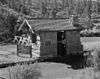
| 17 |
Museum-Grotto Residence |
|
000000001987-02-14-0000February 14, 1987
(#86003721) |
Southeast of Grotto Picnic Area
37°15′28″N 112°57′03″W / 37.257778°N 112.950833°W / 37.257778; -112.950833 (Museum-Grotto Residence) |
|
| 18 |
Oak Creek Historic District |
|
000000001987-07-07-0000July 7, 1987
(#86003706) |
Off State Route 9 along bank of Oak Creek
37°12′40″N 112°59′10″W / 37.211111°N 112.986111°W / 37.211111; -112.986111 (Oak Creek Historic District) |
|
| 19 |
Oak Creek Irrigation Canal |
|
000000001987-07-07-0000July 7, 1987
(#86003738) |
Western side of the North Fork of the Virgin River, 1/8 miles north of the Virgin River Bridge to the northern side of Watchman Campground Entrance Rd.
37°12′09″N 112°59′28″W / 37.2025°N 112.991111°W / 37.2025; -112.991111 (Oak Creek Irrigation Canal) |
|
| 20 |
Parunuweap Canyon Archeological District |
|
000000001996-11-07-0000November 7, 1996
(#96001235) |
Address Restricted
|
|
| 21 |
Pine Creek Irrigation Canal |
|
000000001987-07-07-0000July 7, 1987
(#86003734) |
Eastern bank of the Virgin River 0.25 miles north of the Virgin River bridge to the southwestern end of the Watchman Residential Loop
37°12′06″N 112°58′40″W / 37.201667°N 112.977778°W / 37.201667; -112.977778 (Pine Creek Irrigation Canal) |
|
| 22 |
Pine Creek Residential Historic District |
|
000000001987-07-07-0000July 7, 1987
(#86003736) |
Western side of State Route 9 500 feet south of the bridge over the Virgin River
37°12′59″N 112°58′32″W / 37.216389°N 112.975556°W / 37.216389; -112.975556 (Pine Creek Residential Historic District) |
|
| 23 |
South Campground Amphitheater |
|
000000001987-02-14-0000February 14, 1987
(#86003717) |
South Campground
37°12′12″N 112°58′55″W / 37.203333°N 112.981944°W / 37.203333; -112.981944 (South Campground Amphitheater) |
|
| 24 |
South Campground Comfort Station |
|
000000001987-02-14-0000February 14, 1987
(#86003708) |
South Campground at the northern end of the campsite loop
37°12′14″N 112°58′21″W / 37.203889°N 112.9725°W / 37.203889; -112.9725 (South Campground Comfort Station) |
|
| 25 |
South Entrance Sign |
|
000000001987-02-14-0000February 14, 1987
(#86003713) |
South Entrance
37°12′04″N 112°59′22″W / 37.201111°N 112.989444°W / 37.201111; -112.989444 (South Entrance Sign) |
|
| 26 |
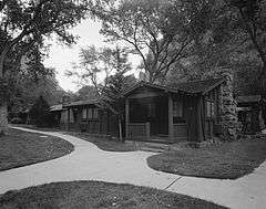
Zion Lodge Historic District |
|
000000001982-08-24-0000August 24, 1982
(#82001718) |
North of Springdale in Zion National Park; also west of State Route 9 on the eastern and western sides of The Zion Canyon Scenic Drive near Birch Creek
37°15′01″N 112°57′17″W / 37.250278°N 112.954722°W / 37.250278; -112.954722 (Zion Lodge Historic District) |
Second set of boundaries represents a boundary increase
|
| 27 |
Zion Nature Center-Zion Inn |
|
000000001987-02-14-0000February 14, 1987
(#86003719) |
North of South Campground facilities
37°12′21″N 112°58′25″W / 37.205833°N 112.973611°W / 37.205833; -112.973611 (Zion Nature Center-Zion Inn) |
|
| 28 |
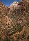
Zion – Mount Carmel Highway |
|
000000001987-07-07-0000July 7, 1987
(#86003709) |
Between U.S. Route 89 and State Route 9
37°13′19″N 112°55′58″W / 37.221944°N 112.932778°W / 37.221944; -112.932778 (Zion – Mount Carmel Highway) |
|
.jpg)