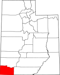
| [3] |
Name on the Register[4] |
Image |
Date listed[5] |
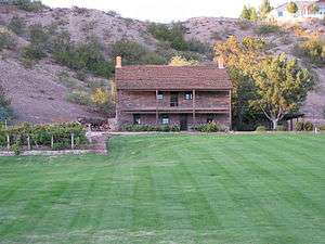
Location |
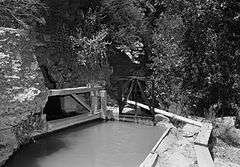
City or town |
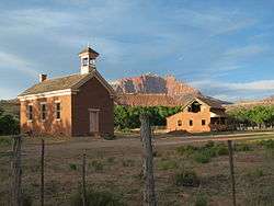
Description |
|---|
| 1 |
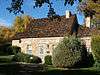
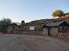
Wallace Blake House |
|
000000001978-11-14-0000November 14, 1978
(#78002709) |
South of St. George
37°02′49″N 113°36′15″W / 37.046944°N 113.604167°W / 37.046944; -113.604167 (Wallace Blake House) |
St. George |
|
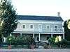
| 2 |
Bradshaw House-Hotel |
Upload image |
000000001991-09-26-0000September 26, 1991
(#91001443) |
85 S. Main St.
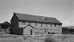
37°10′31″N 113°17′13″W / 37.175278°N 113.286944°W / 37.175278; -113.286944 (Bradshaw House-Hotel) |
Hurricane |
|
| 3 |
William F. Butler House |
|
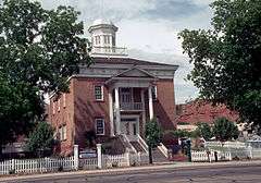
000000001984-07-13-0000July 13, 1984
(#84002433) |
168 S. 300 West
37°06′19″N 113°35′21″W / 37.105278°N 113.589167°W / 37.105278; -113.589167 (William F. Butler House) |
St. George |
|
| 4 |
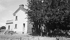
Robert D. Covington House |
|
000000001978-04-20-0000April 20, 1978
(#78002711) |
200 N. 200 East
37°08′05″N 113°30′20″W / 37.134722°N 113.505556°W / 37.134722; -113.505556 (Robert D. Covington House) |
Washington |
|
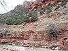
| 5 |
Crawford Irrigation Canal |
|
000000001987-07-07-0000July 7, 1987
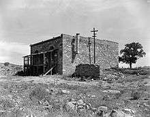
(#86003732) |
Western bank of the Virgin River from 1 mile (1.6 km) north of the Virgin River bridge to the base of the Virgin River Formation and .5 miles (0.80 km) up Oak Creek
37°12′40″N 112°59′33″W / 37.211111°N 112.9925°W / 37.211111; -112.9925 (Crawford Irrigation Canal) |
Springdale |
|
| 6 |
Deseret Telegraph and Post Office |
|
000000001972-02-23-0000February 23, 1972
(#72001263) |
On State Route 9
37°09′39″N 113°02′34″W / 37.160833°N 113.042778°W / 37.160833; -113.042778 (Deseret Telegraph and Post Office) |
Rockville |
|
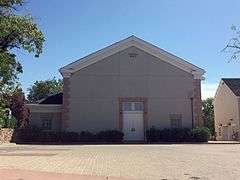
| 7 |
Enterprise Meetinghouse |
Upload image |
000000001993-05-14-0000May 14, 1993
(#93000410) |
Approximately 24 S. Center St.
37°34′23″N 113°43′16″W / 37.573056°N 113.721111°W / 37.573056; -113.721111 (Enterprise Meetinghouse) |
Enterprise |
|
| 8 |
Thomas Forsyth House |
Upload image |
000000001982-02-11-0000February 11, 1982
(#82004184) |
111 N. Toquerville Boulevard
37°15′11″N 113°17′06″W / 37.252917°N 113.285°W / 37.252917; -113.285 (Thomas Forsyth House) |
Toquerville |
|
| 9 |
Fort Harmony Site |
Upload image |
000000001979-11-16-0000November 16, 1979
(#79003493) |
East of New Harmony and west of I-15
37°28′51″N 113°14′34″W / 37.480833°N 113.242778°W / 37.480833; -113.242778 (Fort Harmony Site) |
New Harmony |
|
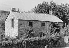
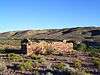
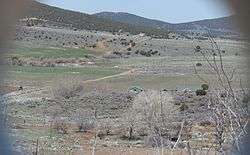
| 10 |
Fort Pearce |
|
000000001975-11-20-0000November 20, 1975
(#75001834) |
Warner Valley Rd., 12 miles (19 km) southeast of Washington off Interstate 15
37°00′28″N 113°24′41″W / 37.007778°N 113.411389°W / 37.007778; -113.411389 (Fort Pearce) |
Washington |
|
| 11 |
George and Bertha Graff House |
|
000000001998-12-04-0000December 4, 1998
(#98001461) |
2865 Santa Clara Dr.
37°07′56″N 113°39′01″W / 37.132222°N 113.650278°W / 37.132222; -113.650278 (George and Bertha Graff House) |
Santa Clara |
|
| 12 |
Grafton Historic District |
|
000000002010-09-09-0000September 9, 2010
(#10000732) |
Beginning at Hall and Grafton Ditch and the Grafton to Rockville Rd.[6]
37°10′00″N 113°05′06″W / 37.166667°N 113.085°W / 37.166667; -113.085 (Grafton Historic District) |
Rockville |
|
| 13 |
Hans George Hafen House |
|
000000001998-12-04-0000December 4, 1998
(#98001462) |
3003 Santa Clara Dr.
37°07′57″N 113°39′10″W / 37.1325°N 113.652778°W / 37.1325; -113.652778 (Hans George Hafen House) |
Santa Clara |
|
| 14 |
Jacob Hamblin House |
|
000000001971-03-11-0000March 11, 1971
(#71000860) |
3400 Hamblin Dr.
37°08′00″N 113°39′36″W / 37.133333°N 113.66°W / 37.133333; -113.66 (Jacob Hamblin House) |
Santa Clara |
|
| 15 |
Hurricane Canal |
|
000000001977-08-29-0000August 29, 1977
(#77001324) |
East of Hurricane
37°10′45″N 113°15′59″W / 37.179167°N 113.266389°W / 37.179167; -113.266389 (Hurricane Canal) |
Hurricane |
|
| 16 |
Hurricane Historic District |
Upload image |
000000001995-08-04-0000August 4, 1995
(#95000980) |
Roughly bounded by 300 South, 200 West, State St. and the Hurricane Canal
37°10′26″N 113°17′19″W / 37.173889°N 113.288611°W / 37.173889; -113.288611 (Hurricane Historic District) |
Hurricane |
|
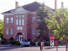
| 17 |
Hurricane Library-City Hall |
Upload image |
000000001991-09-26-0000September 26, 1991
(#91001444) |
35 W. State St.
37°10′35″N 113°17′17″W / 37.176389°N 113.288056°W / 37.176389; -113.288056 (Hurricane Library-City Hall) |
Hurricane |
|
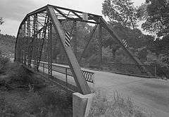
| 18 |
Hurricane-LaVerkin Bridge |
|
000000001995-04-14-0000April 14, 1995
(#95000413) |
East of State Route 9 over the Virgin River
37°11′22″N 113°16′13″W / 37.189444°N 113.270278°W / 37.189444; -113.270278 (Hurricane-LaVerkin Bridge) |
Hurricane |
|
| 19 |
Samuel and Elizabeth Isom House |
Upload image |
000000001993-03-04-0000March 4, 1993
(#93000063) |
188 S. 100 West
37°10′26″N 113°17′21″W / 37.173889°N 113.289167°W / 37.173889; -113.289167 (Samuel and Elizabeth Isom House) |
Hurricane |
|
| 20 |
James Jepson, Jr. House |
Upload image |
000000002000-06-22-0000June 22, 2000
(#00000732) |
15 E. Jepson St.
37°11′59″N 113°11′08″W / 37.199722°N 113.185556°W / 37.199722; -113.185556 (James Jepson, Jr. House) |
Virgin |
|
| 21 |
Thomas Judd House |
Upload image |
000000001978-01-31-0000January 31, 1978
(#78002710) |
269 S. 200 East
37°06′08″N 113°34′40″W / 37.102222°N 113.577778°W / 37.102222; -113.577778 (Thomas Judd House) |
St. George |
|
| 22 |
Lemuel and Mary Ann Leavitt House |
Upload image |
000000001999-02-12-0000February 12, 1999
(#99000215) |
1408 N. Quail St.
37°07′58″N 113°39′18″W / 37.132778°N 113.655°W / 37.132778; -113.655 (Lemuel and Mary Ann Leavitt House) |
Santa Clara |
|
| 23 |
Leeds CCC Camp Historic District |
|
000000001993-03-04-0000March 4, 1993
(#93000062) |
96 W. Mulberry
37°14′05″N 113°22′00″W / 37.234722°N 113.366667°W / 37.234722; -113.366667 (Leeds CCC Camp Historic District) |
Leeds |
|
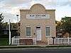
| 24 |
Leeds Tithing Office |
Upload image |
000000001985-01-25-0000January 25, 1985
(#85000291) |
Southwestern corner of 100 West and 100 North
37°14′11″N 113°21′44″W / 37.236389°N 113.362222°W / 37.236389; -113.362222 (Leeds Tithing Office) |
Leeds |
|
| 25 |
Main Building of Dixie College |
|
000000001980-06-19-0000June 19, 1980
(#80003988) |
86 S. Main St.
37°06′25″N 113°34′58″W / 37.106944°N 113.582778°W / 37.106944; -113.582778 (Main Building of Dixie College) |
St. George |
|
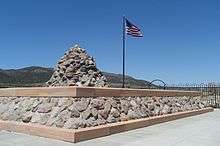
| 26 |
Mountain Meadows Historic Site |
|
000000001975-08-28-0000August 28, 1975
(#75001833) |
7 miles (11 km) south of Enterprise on State Route 18
37°28′57″N 113°38′10″W / 37.4825°N 113.636111°W / 37.4825; -113.636111 (Mountain Meadows Historic Site) |
Enterprise |
|
| 27 |
Mountain Meadows Massacre Site |
|
000000002011-06-23-0000June 23, 2011
(#11000562) |
West of State Route 18, approximately 3 miles (4.8 km) north of Central
37°28′32″N 113°38′37″W / 37.475556°N 113.643611°W / 37.475556; -113.643611 (Mountain Meadows Massacre Site) |
Central vicinity |
Comprises approximately 760 acres (3.1 km2) within the 3,000-acre (12 km2) Mountain Meadows Historic Site[7]
|
| 28 |
Naegle Winery |
|
000000001980-02-20-0000February 20, 1980
(#80003990) |
110 S. Toquer Boulevard
37°14′55″N 113°17′02″W / 37.2486889°N 113.283889°W / 37.2486889; -113.283889 (Naegle Winery) |
Toquerville |
|
| 29 |
Old Washington County Courthouse |
|
000000001970-09-22-0000September 22, 1970
(#70000634) |
85 E. 100 North
37°06′39″N 113°34′50″W / 37.110833°N 113.580556°W / 37.110833; -113.580556 (Old Washington County Courthouse) |
St. George |
|
| 30 |
Pine Valley Chapel and Tithing Office |
|
000000001971-04-16-0000April 16, 1971
(#71000859) |
Main and Grass Valley Sts.
37°23′39″N 113°30′56″W / 37.394167°N 113.515556°W / 37.394167; -113.515556 (Pine Valley Chapel and Tithing Office) |
Pine Valley |
|
| 31 |
Orson Pratt House |
|
000000001983-08-11-0000August 11, 1983
(#83003199) |
76 W. Tabernacle St.
37°06′31″N 113°35′01″W / 37.108611°N 113.583611°W / 37.108611; -113.583611 (Orson Pratt House) |
St. George |
|
| 32 |
Frederick and Anna Maria Reber House |
Upload image |
000000001998-12-04-0000December 4, 1998
(#98001448) |
2988-2990 Santa Clara Dr.
37°07′59″N 113°39′09″W / 37.133056°N 113.6525°W / 37.133056; -113.6525 (Frederick and Anna Maria Reber House) |
Santa Clara |
|
| 33 |
Frederick, Jr., and Mary F. Reber House |
Upload image |
000000001999-02-12-0000February 12, 1999
(#99000214) |
3334 Hamblin Dr.
37°08′01″N 113°39′32″W / 37.133611°N 113.658889°W / 37.133611; -113.658889 (Frederick, Jr., and Mary F. Reber House) |
Santa Clara |
|
| 34 |
Rockville Bridge |
|
000000001995-08-04-0000August 4, 1995
(#95000982) |
150 S. Bridge Rd. over the East Fork of the Virgin River
37°09′30″N 113°02′16″W / 37.158333°N 113.037778°W / 37.158333; -113.037778 (Rockville Bridge) |
Rockville |
|
| 35 |
St. George Elementary School |
Upload image |
000000001985-04-01-0000April 1, 1985
(#85000820) |
120 S. 100 West
37°06′28″N 113°35′06″W / 37.107778°N 113.585°W / 37.107778; -113.585 (St. George Elementary School) |
St. George |
|
| 36 |
St. George Social Hall |
|
000000001991-04-03-0000April 3, 1991
(#91000360) |
212 N. Main St.
37°06′43″N 113°34′56″W / 37.111944°N 113.582222°W / 37.111944; -113.582222 (St. George Social Hall) |
St. George |
|
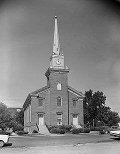
| 37 |
St. George Tabernacle |
|
000000001971-05-14-0000May 14, 1971
(#71000862) |
Junction of Tabernacle and Main Sts.
37°06′29″N 113°34′58″W / 37.108056°N 113.582778°W / 37.108056; -113.582778 (St. George Tabernacle) |
St. George |
|
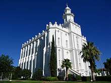
| 38 |
St. George Temple |
|
000000001977-11-07-0000November 7, 1977
(#77001325) |
Bounded by 200 East, 300 East, 400 South, and 500 South
37°06′02″N 113°34′38″W / 37.100556°N 113.577222°W / 37.100556; -113.577222 (St. George Temple) |
St. George |
|
| 39 |
Santa Clara Hydroelectric Power Plants Historic District |
Upload image |
000000001989-04-21-0000April 21, 1989
(#89000281) |
Off State Route 18 on the Santa Clara River
37°18′25″N 113°42′40″W / 37.306944°N 113.711111°W / 37.306944; -113.711111 (Santa Clara Hydroelectric Power Plants Historic District) |
Gunlock and Veyo |
|
| 40 |
Santa Clara Relief Society House |
|
000000001994-02-02-0000February 2, 1994
(#93001577) |
Approximately 3036 W. Santa Clara Dr.
37°07′59″N 113°39′10″W / 37.133056°N 113.652778°W / 37.133056; -113.652778 (Santa Clara Relief Society House) |
Santa Clara |
|
| 41 |
Santa Clara Tithing Granary |
Upload image |
000000001998-12-04-0000December 4, 1998
(#98001460) |
3105 Santa Clara Dr.
37°07′58″N 113°39′18″W / 37.132778°N 113.655°W / 37.132778; -113.655 (Santa Clara Tithing Granary) |
Santa Clara |
|
| 42 |
Southern Paiute Archeological District |
|
000000001982-06-11-0000June 11, 1982
(#82004185) |
Address Restricted[8]
|
Washington |
|
| 43 |
Emanuel and Ursella Stanworth House |
Upload image |
000000001992-12-17-0000December 17, 1992
(#92001692) |
198 S. Main St.
37°10′26″N 113°17′15″W / 37.173889°N 113.2875°W / 37.173889; -113.2875 (Emanuel and Ursella Stanworth House) |
Hurricane |
|
| 44 |
John Steele House |
Upload image |
000000001988-04-07-0000April 7, 1988
(#88000401) |
263 N. Toquerville Boulevard
37°15′20″N 113°17′08″W / 37.255556°N 113.285556°W / 37.255556; -113.285556 (John Steele House) |
Toquerville |
|
| 45 |
Washington Cotton Factory |
|
000000001971-04-16-0000April 16, 1971
(#71000864) |
385 Telegraph St.
37°07′45″N 113°30′53″W / 37.129167°N 113.514722°W / 37.129167; -113.514722 (Washington Cotton Factory) |
Washington |
|
| 46 |
Washington Relief Society Hall |
Upload image |
000000001980-08-27-0000August 27, 1980
(#80003991) |
100 W. Telegraph St.
37°07′48″N 113°30′41″W / 37.13°N 113.511389°W / 37.13; -113.511389 (Washington Relief Society Hall) |
Washington |
|
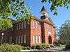
| 47 |
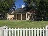
Washington School |
Upload image |
000000001980-11-23-0000November 23, 1980
(#80003992) |
25 E. Telegraph St.
37°07′50″N 113°30′34″W / 37.130556°N 113.509444°W / 37.130556; -113.509444 (Washington School) |
Washington |
Now a museum
|
| 48 |
Wells Fargo and Company Express Building |
|
000000001971-03-11-0000March 11, 1971
(#71000861) |
Wells Fargo Rd.
37°15′11″N 113°22′00″W / 37.253056°N 113.366667°W / 37.253056; -113.366667 (Wells Fargo and Company Express Building) |
Silver Reef |
|
| 49 |
Woodward School |
|
000000001980-11-23-0000November 23, 1980
(#80003989) |
100 West and Tabernacle Sts.
37°06′28″N 113°35′02″W / 37.107778°N 113.583889°W / 37.107778; -113.583889 (Woodward School) |
St. George |
|
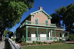
| 50 |
Brigham Young Winter Home and Office |
|
000000001971-02-22-0000February 22, 1971
(#71000863) |
Corner of 200 North and 100 West
37°06′41″N 113°35′06″W / 37.111389°N 113.585°W / 37.111389; -113.585 (Brigham Young Winter Home and Office) |
St. George |
|