| [3] |
Name on the Register[4] |
Image |
Date listed[5] |
Location |
City or town |
Description |
|---|
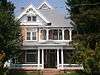
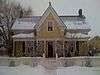
| 1 |
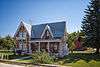
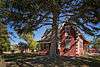
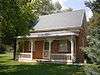
Austin-Wherritt House |
|
000000001979-01-25-0000January 25, 1979
(#79002520) |
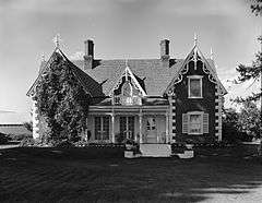
315 E. Center St.
40°30′28″N 111°24′25″W / 40.507778°N 111.406944°W / 40.507778; -111.406944 (Austin-Wherritt House) |
Heber City |
|
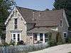
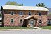
| 2 |
George Blackley House |
|
000000001985-06-27-0000June 27, 1985
(#85001392) |
421 E. 200 North
40°30′38″N 111°24′19″W / 40.510556°N 111.405278°W / 40.510556; -111.405278 (George Blackley House) |
Heber City |
|
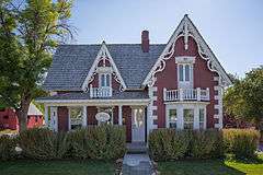
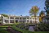
| 3 |
George Bonner, Jr., House |
|
000000001986-06-17-0000June 17, 1986
(#86001357) |
90 E. Main St.
40°30′43″N 111°28′11″W / 40.511944°N 111.469722°W / 40.511944; -111.469722 (George Bonner, Jr., House) |
Midway |
Designed and built by John Watkins
|
| 4 |
George Bonner, Sr., House |
|
000000001986-06-17-0000June 17, 1986
(#86001359) |
103 E. Main St.
40°30′44″N 111°28′09″W / 40.512222°N 111.469167°W / 40.512222; -111.469167 (George Bonner, Sr., House) |
Midway |
Designed and built by John Watkins
|
| 5 |
William Bonner House |
|
000000001986-06-17-0000June 17, 1986
(#86001361) |
110 E. Main St.
40°30′43″N 111°28′09″W / 40.511944°N 111.469167°W / 40.511944; -111.469167 (William Bonner House) |
Midway |
|
| 6 |
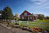
Burgener-Boss Farmstead |
|
000000001994-05-26-0000May 26, 1994
(#94000534) |
102 W. 100 North
40°30′51″N 111°28′32″W / 40.514167°N 111.475556°W / 40.514167; -111.475556 (Burgener-Boss Farmstead) |
Midway |
|
| 7 |
Clotworthy-McMillan House |
|
000000001999-02-12-0000February 12, 1999
(#99000216) |
261 S. Main St.
40°30′15″N 111°24′45″W / 40.504167°N 111.4125°W / 40.504167; -111.4125 (Clotworthy-McMillan House) |
Heber City |
|
| 8 |
James William Clyde House |
|
000000001996-10-18-0000October 18, 1996
(#96001170) |
312 S. Main St.
40°30′12″N 111°24′47″W / 40.503333°N 111.413056°W / 40.503333; -111.413056 (James William Clyde House) |
Heber City |
|
| 9 |
William Coleman House |
|
000000001986-06-17-0000June 17, 1986
(#86001362) |
180 N. Center St.
40°30′57″N 111°28′16″W / 40.515833°N 111.471111°W / 40.515833; -111.471111 (William Coleman House) |
Midway |
|
| 10 |
Heber and Matilda Crook House and Lake Creek Schoolhouse |
|
000000001995-04-17-0000April 17, 1995
(#95000414) |
4800 E. Lake Creek Rd.
40°30′00″N 111°19′35″W / 40.5°N 111.326389°W / 40.5; -111.326389 (Heber and Matilda Crook House and Lake Creek Schoolhouse) |
Heber City |
|
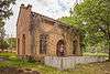
| 11 |
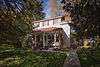
John Crook House |
|
000000001978-11-16-0000November 16, 1978
(#78002705) |
188 W. 3rd North
40°30′43″N 111°24′57″W / 40.511944°N 111.415833°W / 40.511944; -111.415833 (John Crook House) |
Heber City |
|
| 12 |
David Fisher House |
|
000000001980-04-16-0000April 16, 1980
(#80003984) |
124 E. 400 South
40°30′08″N 111°24′38″W / 40.502222°N 111.410556°W / 40.502222; -111.410556 (David Fisher House) |
Heber City |
|
| 13 |
Abram Hatch House |
|
000000001975-10-10-0000October 10, 1975
(#75001832) |
81 E. Center St.
40°30′28″N 111°24′42″W / 40.507778°N 111.411667°W / 40.507778; -111.411667 (Abram Hatch House) |
Heber City |
|
| 14 |
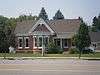
Heber Second Ward Meetinghouse |
|
000000001978-12-12-0000December 12, 1978
(#78002706) |
1st West and Center Sts.
40°30′26″N 111°24′51″W / 40.507222°N 111.414167°W / 40.507222; -111.414167 (Heber Second Ward Meetinghouse) |
Heber City |
|
| 15 |
Lester F. and Margaret Stewart Hewlett Ranch House |
Upload image |
000000001985-05-23-0000May 23, 1985
(#85001134) |
Off State Route 35
40°34′45″N 111°07′34″W / 40.579167°N 111.126111°W / 40.579167; -111.126111 (Lester F. and Margaret Stewart Hewlett Ranch House) |
Woodland |
|
| 16 |
John Huber House and Creamery |
|
000000001988-08-11-0000August 11, 1988
(#88001182) |
Off Snake Creek Canyon Rd.
40°32′31″N 111°29′53″W / 40.541944°N 111.498056°W / 40.541944; -111.498056 (John Huber House and Creamery) |
Midway |
Part of Wasatch Mountain State Park
|
| 17 |
Midway Social Hall |
|
000000001995-08-10-0000August 10, 1995
(#95000981) |
71 E. Main St.
40°30′45″N 111°28′13″W / 40.5125°N 111.470278°W / 40.5125; -111.470278 (Midway Social Hall) |
Midway |
|
| 18 |
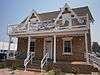
Midway Town Hall |
|
000000001994-12-01-0000December 1, 1994
(#94001347) |
120 W. Main St.
40°30′45″N 111°28′48″W / 40.5125°N 111.48°W / 40.5125; -111.48 (Midway Town Hall) |
Midway |
|
| 19 |
John Murdoch House |
|
000000001980-02-28-0000February 28, 1980
(#80003985) |
261 N. 400 West
40°30′40″N 111°25′12″W / 40.511111°N 111.42°W / 40.511111; -111.42 (John Murdoch House) |
Heber City |
|
| 20 |
Joseph S. Murdock House |
|
000000001987-05-01-0000May 1, 1987
(#87000701) |
115 E. 300 North
40°30′42″N 111°24′38″W / 40.511667°N 111.410556°W / 40.511667; -111.410556 (Joseph S. Murdock House) |
Heber City |
|
| 21 |
Schneitter Hotel |
|
000000001992-12-17-0000December 17, 1992
(#92001691) |
700 N. Homestead Dr.
40°31′22″N 111°29′03″W / 40.522778°N 111.484167°W / 40.522778; -111.484167 (Schneitter Hotel) |
Midway |
|
| 22 |
Snake Creek Hydroelectric Power Plant Historic District |
|
000000001989-04-21-0000April 21, 1989
(#89000279) |
Snake Creek Canyon Rd.
40°33′20″N 111°31′12″W / 40.555556°N 111.52°W / 40.555556; -111.52 (Snake Creek Hydroelectric Power Plant Historic District) |
Midway |
Part of Wasatch Mountain State Park
|
| 23 |
Stewart Ranch Foreman's House |
Upload image |
000000001985-05-23-0000May 23, 1985
(#85001135) |
Off State Route 35
40°33′28″N 111°08′06″W / 40.557778°N 111.135°W / 40.557778; -111.135 (Stewart Ranch Foreman's House) |
Woodland |
|
| 24 |
Barnard J. Stewart Ranch House |
Upload image |
000000001985-05-23-0000May 23, 1985
(#85001136) |
Off State Route 35
40°34′00″N 111°07′57″W / 40.566667°N 111.1325°W / 40.566667; -111.1325 (Barnard J. Stewart Ranch House) |
Woodland |
|
| 25 |
Charles B. Stewart Ranch House |
Upload image |
000000001985-05-23-0000May 23, 1985
(#85001137) |
Off State Route 35
40°34′48″N 111°07′32″W / 40.58°N 111.125556°W / 40.58; -111.125556 (Charles B. Stewart Ranch House) |
Woodland |
|
| 26 |
Samuel W. Stewart Ranch House |
Upload image |
000000001985-05-23-0000May 23, 1985
(#85001138) |
Off State Route 35
40°33′26″N 111°08′05″W / 40.557222°N 111.134722°W / 40.557222; -111.134722 (Samuel W. Stewart Ranch House) |
Woodland |
|
| 27 |
Stewart-Hewlett Ranch Dairy Barn |
Upload image |
000000001985-05-23-0000May 23, 1985
(#85001139) |
Off State Route 35
40°33′23″N 111°08′08″W / 40.556389°N 111.135556°W / 40.556389; -111.135556 (Stewart-Hewlett Ranch Dairy Barn) |
Woodland |
|
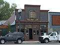
| 28 |
Wasatch Saloon |
|
000000001980-09-23-0000September 23, 1980
(#80003986) |
139 N. Main St.
40°30′34″N 111°24′47″W / 40.509444°N 111.413056°W / 40.509444; -111.413056 (Wasatch Saloon) |
Heber City |
|
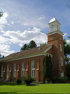
| 29 |
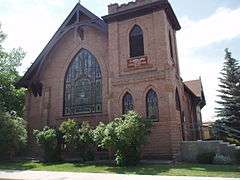
Wasatch Stake Tabernacle and Heber Amusement Hall |
|
000000001970-12-02-0000December 2, 1970
(#70000633) |
Main St. at 100 North St. and 100 West St. corners
40°30′32″N 111°24′50″W / 40.508889°N 111.413889°W / 40.508889; -111.413889 (Wasatch Stake Tabernacle and Heber Amusement Hall) |
Heber City |
Wasatch Stake Tabernacle and Heber Amusement Hall
|
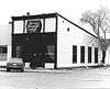
| 30 |
Wasatch Wave Publishing Company Building |
|
000000001979-12-27-0000December 27, 1979
(#79002519) |
55 W. Center St.
40°30′26″N 111°24′44″W / 40.507222°N 111.412222°W / 40.507222; -111.412222 (Wasatch Wave Publishing Company Building) |
Heber City |
Demolished in approximately 2000
|
| 31 |
John and Margaret Watkins House |
|
000000001986-06-17-0000June 17, 1986
(#86001364) |
22 W. 100 South
40°30′39″N 111°28′21″W / 40.510833°N 111.4725°W / 40.510833; -111.4725 (John and Margaret Watkins House) |
Midway |
|
| 32 |
Watkins-Coleman House |
|
000000001971-05-14-0000May 14, 1971
(#71000858) |
5 E. Main St.
40°30′45″N 111°28′16″W / 40.5125°N 111.471111°W / 40.5125; -111.471111 (Watkins-Coleman House) |
Midway |
Designed and built by John Watkins
|
| 33 |
Ethelbert White and William M. Stewart Ranch House |
Upload image |
000000001985-05-23-0000May 23, 1985
(#85001140) |
Off State Route 35
40°33′29″N 111°08′05″W / 40.558056°N 111.134722°W / 40.558056; -111.134722 (Ethelbert White and William M. Stewart Ranch House) |
Woodland |
|
| 34 |
Wilson House and Farmstead |
|
000000002007-07-03-0000July 3, 2007
(#07000667) |
94 E. 250 North
40°31′05″N 111°28′14″W / 40.518056°N 111.470556°W / 40.518056; -111.470556 (Wilson House and Farmstead) |
Midway |
|
| 35 |
Attewall Wootton, Jr. House |
|
000000001980-04-10-0000April 10, 1980
(#80003987) |
Approximately 285 E. Main St.
40°30′45″N 111°27′19″W / 40.5125°N 111.455278°W / 40.5125; -111.455278 (Attewall Wootton, Jr. House) |
Midway |
|