National Register of Historic Places listings in Morgan County, Utah
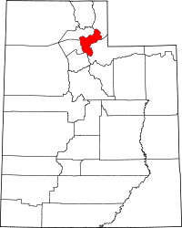
Location of Morgan County in Utah
This is a list of the National Register of Historic Places listings in Morgan County, Utah.
This is intended to be a complete list of the properties and districts on the National Register of Historic Places in Morgan County, Utah, United States. Latitude and longitude coordinates are provided for many National Register properties and districts; these locations may be seen together in a map.[1]
There are 7 properties and districts listed on the National Register in the county.
- This National Park Service list is complete through NPS recent listings posted December 2, 2016.[2]
Current listings
| [3] | Name on the Register[4] | Image | Date listed[5] | Location | City or town | Description |
|---|---|---|---|---|---|---|
| 1 | Devil's Gate-Weber Hydroelectric Power Plant Historic District | 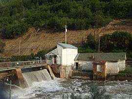 |
(#89000276) |
I-84 east of its junction with US-89, in Weber Canyon 41°08′18″N 111°52′02″W / 41.138333°N 111.867222°W |
Uintah | |
| 2 | Daniel Heiner House | 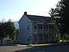 |
(#78002664) |
543 N. 700 East 41°03′03″N 111°40′36″W / 41.050833°N 111.676667°W |
Morgan | |
| 3 | Morgan Elementary School | 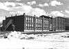 |
(#86000737) |
75 N. 100 East 41°02′17″N 111°40′20″W / 41.038056°N 111.672222°W |
Morgan | Demolished in August 1994 |
| 4 | Morgan High School Mechanical Arts Building | 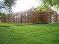 |
(#86000738) |
20 N. 100 East 41°02′13″N 111°40′31″W / 41.036944°N 111.675278°W |
Morgan | |
| 5 | Morgan Union Pacific Depot | 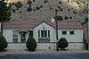 |
(#11000757) |
98 N. Commercial St. 41°02′28″N 111°39′58″W / 41.041111°N 111.666111°W |
Morgan | |
| 6 | Mormon Flat Breastworks | 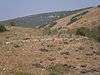 |
(#88001943) |
Along Jeremy Ranch Rd. at the mouth of Little Emigration Canyon[6] 40°48′55″N 111°35′15″W / 40.815278°N 111.5875°W |
Porterville | |
| 7 | South Round Valley School | 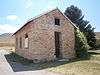 |
(#11000233) |
1925 E. Round Valley Rd. 41°02′30″N 111°39′12″W / 41.041667°N 111.653333°W |
Morgan vicinity |
See also
References
- ↑ The latitude and longitude information provided in this table was derived originally from the National Register Information System, which has been found to be fairly accurate for about 99% of listings. For about 1% of NRIS original coordinates, experience has shown that one or both coordinates are typos or otherwise extremely far off; some corrections may have been made. A more subtle problem causes many locations to be off by up to 150 yards, depending on location in the country: most NRIS coordinates were derived from tracing out latitude and longitudes off of USGS topographical quadrant maps created under the North American Datum of 1927, which differs from the current, highly accurate WGS84 GPS system used by most on-line maps. Chicago is about right, but NRIS longitudes in Washington are higher by about 4.5 seconds, and are lower by about 2.0 seconds in Maine. Latitudes differ by about 1.0 second in Florida. Some locations in this table may have been corrected to current GPS standards.
- ↑ "National Register of Historic Places: Weekly List Actions". National Park Service, United States Department of the Interior. Retrieved on December 2, 2016.
- ↑ Numbers represent an ordering by significant words. Various colorings, defined here, differentiate National Historic Landmarks and historic districts from other NRHP buildings, structures, sites or objects.
- ↑ National Park Service (2008-04-24). "National Register Information System". National Register of Historic Places. National Park Service.
- ↑ The eight-digit number below each date is the number assigned to each location in the National Register Information System database, which can be viewed by clicking the number.
- ↑ Location derived from this Utah state government website; the NRIS lists the site as "Address Restricted"
External links
![]() Media related to National Register of Historic Places in Morgan County, Utah at Wikimedia Commons
Media related to National Register of Historic Places in Morgan County, Utah at Wikimedia Commons
 |  | ||
| Topics | |
|---|---|
| Lists by states |
|
| Lists by insular areas | |
| Lists by associated states | |
| Other areas | |
| |
Municipalities and communities of Morgan County, Utah, United States | ||
|---|---|---|
| City | | |
| CDPs | ||
| Unincorporated communities | ||
This article is issued from Wikipedia - version of the 11/22/2016. The text is available under the Creative Commons Attribution/Share Alike but additional terms may apply for the media files.