Nazilli
| Nazilli | |
|---|---|
 Nazilli | |
| Coordinates: TR 37°54′45″N 28°19′14″E / 37.91250°N 28.32056°ECoordinates: TR 37°54′45″N 28°19′14″E / 37.91250°N 28.32056°E | |
| Country | Turkey |
| Province | Aydın |
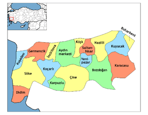
| District | Nazilli |
| Government | |
| • Mayor | Haluk Alıcık |
| • Kaymakam | Mehmet Okur |
| Area[1] | |
| • District | 662.58 km2 (255.82 sq mi) |
| Population (2012)[2] | |
| • Urban | 111,298 |
| • District | 147,668 |
| • District density | 220/km2 (580/sq mi) |
| Website |
www |
Nazilli is the second largest town in Aydın Province in the Aegean region of western Turkey, 47 km (29 mi) east of the city of Aydın, on the road to Denizli.
Etymology
Nazilli is a Turkish name that has somehow evolved from the former (also Turkish) name of Pazarköy (market place). According to legend, the son of Aydın's governor in the Ottoman period, fell in love with a young woman from Pazarköy but was rejected by the girl's father. The young man later named the town Nazlı Ili (Nazlı's Home) after his loved one. The 17th century traveller Evliya Çelebi held that the town was named for the capriciousness ("naz") of the local women in this wealthy town. Or it could have been the name of a family of Oghuz Turks that settled here.
Nazilli was still called Nazli by the British as of 1920.[3]
History
These people practiced weaving and thus planted cotton in the area for this purpose. The Oghuz Turks were succeeded by the Anatolian beyliks of Menteşe (in 1280) and then Aydinids.
In 1390 Bayezid I brought the area into the Ottoman Empire. At this time the town comprised two villages, Cuma Yeri (Friday Square) and Pazarköy (Weekday Market). The town was only later referred to as Nazliköy. In 1402 Tamerlane defeated Bayezid at the Battle of Ankara and took control of the Aegean region, giving the Nazilli area back to the Aydinid family. it was quickly recovered for the Ottomans by Sultan Murat II.
During the Turkish War of Independence Nazilli was occupied by Greek forces and came under Turkish control in September 5, 1922.
Geography
Nazilli stands on the Menderes River and much of the district is in the Menderes valley, full of citrus trees, olives and figs as well as cotton, wheat and other crops.
Economy
Historically Nazilli was a producer of lignite. As of 1914, they were producing large quantities which was managed by a company from the United States. The lignite, in 1920, was described as being "deplorably bad," despite demand for it to be exported to Smyrna.[3] Just north of Nazilli, in 1920, were reported emery mines, too.[4]
Contemporary Nazilli
Nazilli today has a population of 109,800 (according to the 2007 census).
The Basmane-Nazilli Regional railway service runs between İzmir and Nazilli.
References
- ↑ "Area of regions (including lakes), km²". Regional Statistics Database. Turkish Statistical Institute. 2002. Retrieved 2013-03-05.
- ↑ "Population of province/district centers and towns/villages by districts - 2012". Address Based Population Registration System (ABPRS) Database. Turkish Statistical Institute. Retrieved 2013-02-27.
- 1 2 Prothero, G.W. (1920). Anatolia. London: H.M. Stationery Office. p. 101.
- ↑ Prothero, G.W. (1920). Anatolia. London: H.M. Stationery Office. p. 105.