North Branch, Minnesota
| North Branch, Minnesota | |
|---|---|
| City | |
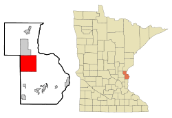 Location of the city of North Branch within Chisago County, Minnesota | |
| Coordinates: 45°30′43″N 92°58′49″W / 45.51194°N 92.98028°W | |
| Country | United States |
| State | Minnesota |
| County | Chisago |
| Area[1] | |
| • Total | 36.04 sq mi (93.34 km2) |
| • Land | 35.60 sq mi (92.20 km2) |
| • Water | 0.44 sq mi (1.14 km2) |
| Elevation | 899 ft (274 m) |
| Population (2010)[2] | |
| • Total | 10,125 |
| • Estimate (2013[3]) | 10,087 |
| • Density | 284.4/sq mi (109.8/km2) |
| Time zone | Central (CST) (UTC-6) |
| • Summer (DST) | CDT (UTC-5) |
| ZIP code | 55056 |
| Area code(s) | 651 |
| FIPS code | 27-46798 |
| GNIS feature ID | 0648609[4] |
| Website | www.ci.north-branch.mn.us |
North Branch is a city in Chisago County, Minnesota, United States, located at the junction of Interstate 35 and Minnesota State Highway 95. The population was 10,125 at the 2010 census.[5] It is named for the north branch of the Sunrise River, which flows through the city.[6]
Geography
According to the United States Census Bureau, the city has a total area of 36.04 square miles (93.34 km2), of which, 35.60 square miles (92.20 km2) is land and 0.44 square miles (1.14 km2) is water.[1]
History
North Branch became a township in 1861, and incorporated in 1881. In 1901, however, North Branch split into a village covering the more densely populated downtown area and a township covering the rest of the former village. The township later incorporated as the village of Branch in 1961. The two cities talked about a potential merger for years, beginning in the late 1970s. The first public referendum on the issue was held in 1984, and it failed. A second referendum was held on September 13, 1994 and passed. The two cities officially merged on November 14, 1994.[7]
Demographics
| Historical population | |||
|---|---|---|---|
| Census | Pop. | %± | |
| 1880 | 142 | — | |
| 1890 | 685 | 382.4% | |
| 1900 | 1,211 | 76.8% | |
| 1910 | 642 | −47.0% | |
| 1920 | 742 | 15.6% | |
| 1930 | 691 | −6.9% | |
| 1940 | 762 | 10.3% | |
| 1950 | 769 | 0.9% | |
| 1960 | 949 | 23.4% | |
| 1970 | 1,106 | 16.5% | |
| 1980 | 1,597 | 44.4% | |
| 1990 | 1,867 | 16.9% | |
| 2000 | 8,023 | 329.7% | |
| 2010 | 10,125 | 26.2% | |
| Est. 2015 | 10,215 | [8] | 0.9% |
| U.S. Decennial Census[9] 2013 Estimate[3] | |||
2010 census
As of the census[2] of 2010, there were 10,125 people, 3,604 households, and 2,591 families residing in the city. The population density was 284.4 inhabitants per square mile (109.8/km2). There were 3,767 housing units at an average density of 105.8 per square mile (40.8/km2). The racial makeup of the city was 96.6% White, 0.5% African American, 0.4% Native American, 0.8% Asian, 0.3% from other races, and 1.3% from two or more races. Hispanic or Latino of any race were 1.9% of the population.
There were 3,604 households of which 42.4% had children under the age of 18 living with them, 57.3% were married couples living together, 9.8% had a female householder with no husband present, 4.9% had a male householder with no wife present, and 28.1% were non-families. 21.2% of all households were made up of individuals and 9.1% had someone living alone who was 65 years of age or older. The average household size was 2.77 and the average family size was 3.25.
The median age in the city was 34.3 years. 29.3% of residents were under the age of 18; 7.7% were between the ages of 18 and 24; 30.4% were from 25 to 44; 22.2% were from 45 to 64; and 10.3% were 65 years of age or older. The gender makeup of the city was 49.8% male and 50.2% female.
2000 census
As of the census of 2000, there were 8,023 people, 2,815 households, and 2,147 families residing in the city. The population density was 224.9 people per square mile (86.8/km²). There were 2,900 housing units at an average density of 81.3 per square mile (31.4/km²). The racial makeup of the city was 97.27% White, 0.16% African American, 0.49% Native American, 1.03% Asian, 0.04% Pacific Islander, 0.21% from other races, and 0.80% from two or more races. Hispanic or Latino of any race were 1.36% of the population.
There were 2,815 households out of which 45.1% had children under the age of 18 living with them, 61.2% were married couples living together, 10.8% had a female householder with no husband present, and 23.7% were non-families. 18.7% of all households were made up of individuals and 7.1% had someone living alone who was 65 years of age or older. The average household size was 2.85 and the average family size was 3.24.
In the city the population was spread out with 33.0% under the age of 18, 7.9% from 18 to 24, 34.5% from 25 to 44, 16.5% from 45 to 64, and 8.1% who were 65 years of age or older. The median age was 30 years. For every 100 females there were 99.6 males. For every 100 females age 18 and over, there were 95.3 males.
The median income for a household in the city was $50,294, and the median income for a family was $56,512. Males had a median income of $39,478 versus $26,424 for females. The per capita income for the city was $20,875. About 3.1% of families and 5.0% of the population were below the poverty line, including 6.6% of those under age 18 and 5.0% of those age 65 or over.
Public schools
- Sunrise River Elementary School
- North Branch Area Middle School
- North Branch Area High School
Notable people
- William J. Duffy – (1916–2013), jurist and legislator. Duffy served in the Wisconsin State Assembly 1949–1950, and was elected a Wisconsin Circuit Court judge for Brown County, Wisconsin serving until his retirement in 1992. Born in North Branch.[10]
- Stephanie Cholensky – Socialist Party USA Chair [11]
- Janet Johnson - Minnesota state senator
- Becky Pearson - one-time LPGA Tour winning golfer and two-time winner of the Minnesota Junior Girls State Championship.[12]
- Doug Mahnke – comic book writer
- Lee Quillen - baseball player for 1906 and 1907 Chicago White Sox
References
- 1 2 "US Gazetteer files 2010". United States Census Bureau. Retrieved 2012-11-13.
- 1 2 "American FactFinder". United States Census Bureau. Retrieved 2012-11-13.
- 1 2 "Population Estimates". United States Census Bureau. Retrieved 2014-07-14.
- ↑ "US Board on Geographic Names". United States Geological Survey. 2007-10-25. Retrieved 2008-01-31.
- ↑ "2010 Census Redistricting Data (Public Law 94-171) Summary File". American FactFinder. U.S. Census Bureau, 2010 Census. Retrieved 23 April 2011.
- ↑ Upham, Warren (1920). Minnesota Geographic Names: Their Origin and Historic Significance. Minnesota Historical Society. p. 108.
- ↑ History of North Branch, Minnesota
- ↑ "Annual Estimates of the Resident Population for Incorporated Places: April 1, 2010 to July 1, 2015". Retrieved July 2, 2016.
- ↑ United States Census Bureau. "Census of Population and Housing". Retrieved July 14, 2014.
- ↑ 'Wisconsin Blue Book 1950,' Biographical Sketch of William J. Duffy, pg. 40
- ↑ http://socialistparty-usa.net/party-structure.html
- ↑ Minnesota Junior Girls State Championship
External links
- City of North Branch
- North Branch Area Chamber of Commerce
- Independent School District #138
- North Branch at the Minnesota Historical Society.
Municipalities and communities of Chisago County, Minnesota, United States | ||
|---|---|---|
| Cities | 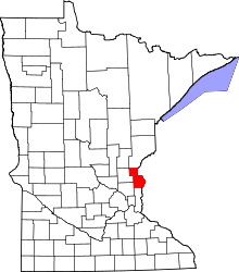 | |
| Townships | ||
| Unincorporated communities | ||
Coordinates: 45°30′41″N 92°58′49″W / 45.51139°N 92.98028°W