Nova Mamoré
| Nova Mamoré | |
|---|---|
| Municipality | |
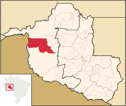 Location in Rondônia state | |
 Nova Mamoré Location in Brazil | |
| Coordinates: 10°24′7″S 65°19′36″W / 10.40194°S 65.32667°WCoordinates: 10°24′7″S 65°19′36″W / 10.40194°S 65.32667°W | |
| Country |
|
| Region | North Region |
| State | Rondônia |
| Area | |
| • Total | 10,072 km2 (3,889 sq mi) |
| Population (2015) | |
| • Total | 27,600 |
| • Density | 2.7/km2 (7.1/sq mi) |
| Time zone | BRT-1 (UTC-4) |
Nova Mamoré is a municipality located in the Brazilian state of Rondônia. As of 2015, the population of Nova Mamoré is 27,600 and its area is 10,072 km².[1]
Economy
The economy of Nova Mamoré is based on mainly agriculture and wood. Its main agriculture comes from the chestnut, cupuaçu, acerola, açaí, guava, mango, and pineapple plants. There are approximately 325,000 cattle in Nova Mamoré. In the 1970s and 80s, the town produced a large amount of gold, but the main mineral source now is water. There are around 27 factories, most of them producing timber.[2]
Reserves
There are three protected areas for indigenous groups in the municipality: Terras Indígenas Igarapé Ribeirão, Reserva dos Karipunas and Terras Indígenas Laje[3] Ninety-five percent of the area of Parque Estadual Guajará-Mirim ("Guajará-Mirim State Park") is located within Nova Mamoré; the remainder is in neighboring Guajará-Mirim.[3] Nova Mamoré contains 27% of the 204,632 hectares (505,660 acres) Rio Ouro Preto Extractive Reserve, created in 1990.[4] The municipality contains 13% of the 197,364 hectares (487,700 acres) Jaci Paraná Extractive Reserve, created in 1996.[5]
References
- ↑ IBGE -
- ↑ http://www.novamamore.ro.gov.br/informacoes.asp
- 1 2 http://www.novamamore.ro.gov.br/municipio/localizacao
- ↑ RESEX do Rio Ouro Preto – ISA, Informações gerais.
- ↑ RESEX Jaci Paraná (in Portuguese), ISA: Instituto Socioambiental, retrieved 2016-10-30
Sources
- RESEX do Rio Ouro Preto (in Portuguese), ISA: Instituto Socioambiental, retrieved 2016-07-31
Capital: Porto Velho | ||
| Alvorada d'Oeste | 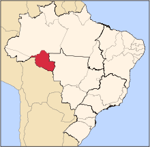 | |
| Ariquemes | ||
| Cacoal | ||
| Colorado do Oeste | ||
| Guajara-Mirim | ||
| Ji-Parana | ||
| Porto Velho | ||
| Vilhena | ||