Patterson, New York
| Patterson | |
| Town | |
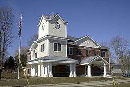 Town Hall | |
| Official name: Town of Patterson | |
| Name origin: after local farmer Mathew Paterson | |
| State | New York |
|---|---|
| Region | Hudson Valley |
| County | Putnam |
| Coordinates | 41°28′N 73°35′W / 41.467°N 73.583°WCoordinates: 41°28′N 73°35′W / 41.467°N 73.583°W |
| Highest point | Cranberry Mountain |
| - elevation | 1,232 ft (376 m) |
| - coordinates | 41°30′N 73°34′W / 41.500°N 73.567°W |
| Lowest point | East Branch Croton River at south town line |
| - elevation | 430 ft (131 m) |
| - coordinates | 41°27′N 73°24′W / 41.450°N 73.400°W |
| Area | 32.9 sq mi (85 km2) |
| - land | 32.3 sq mi (84 km2) |
| - water | 0.6 sq mi (2 km2) |
| Population | 12,023 (2010) |
| Density | 365/sq mi (141/km2) |
| Founded | 1795 |
| Supervisor | Michael Griffin |
| Timezone | EST (UTC-5) |
| - summer (DST) | EDT (UTC-4) |
| ZIP Code | 12563 |
| Area code | 845 Exchange: 278 |
| FIPS code | 36-56748 |
| GNIS feature ID | 0979345 |
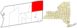 Location of Patterson, New York | |
| Wikimedia Commons: Patterson, New York | |
| Website: Town of Patterson, NY | |
Patterson is a town in Putnam County, New York, United States. The town is in the northeast part of the county. Interstate 84 passes through the southwest part of the town. The population was 12,023 at the 2010 census. The town is named after early farmer Matthew Paterson. The reason Patterson was spelled with two "t"s was due to the looseness with which Paterson spelled his own last name.[1]
History
The town was first settled around 1720 in The Oblong, which was a disputed area in southeastern New York also claimed by the colony of Connecticut. The Oblong was a strip of land approximately 2.9 km wide between Dutchess County New York and Connecticut, ceded to New York in the 1731 Treaty of Dover. Between 1720 and 1776 a large number of mostly Connecticut families settled in the southern Oblong who could not settle west of it because that land was privately owned by the Philipse Family, who owned virtually all of the rest of the future Putnam County. The first such settlers were the Hayt family, who built a house at The Elm in 1720.[2] Another early settler was Jacob Haviland, who settled Haviland Hollow in 1731. The first village in Putnam County, the hamlet of Patterson, was originally called Frederickstown, which lent its name to the eastern part of the future Putnam County other than the oblong, which was called Southeast Precinct (not the same as the current town of Southeast).
After the revolution, the Philipse land was confiscated, and in 1788, the former Philipse portion of the Oblong was chartered as the Town of Southeast, the remainder of the region being chartered as the Town of Fredericktown. In 1795, Fredericktown township was split up into four parts: 1. the Town of Carmel, 2. a part which was combined with the northern half of Southeast and became the Town of Franklin which was renamed the Town of Patterson in 1808, 3. a part which was combined with the southern half of Southeast and became the new, much larger town of Southeast, and 4. the remnant of the town, which was the Town of Frederick for a while, but was renamed the Town of Kent in 1817.[3]
Notable people
- Sybil Ludington – local Revolutionary War Hero
- Pete Seeger – musician[4]
- Martha-Bryan Allen – Broadway actress, aunt of actress Elizabeth Montgomery;[5] the actress owned a summer estate in Patterson, which was sold to the State of New York after her death[6] and is now part of Wonder Lake State Park.[7]
Geography
According to the United States Census Bureau, the town has a total area of 32.9 square miles (85 km2), of which, 32.3 square miles (84 km2) of it is land and 0.6 square miles (1.6 km2) of it (1.95%) is water.
The north town line is the border of Dutchess County, New York, and the east town line is the border of Connecticut.
Demographics
| Historical population | |||
|---|---|---|---|
| Census | Pop. | %± | |
| 1820 | 1,578 | — | |
| 1830 | 1,536 | −2.7% | |
| 1840 | 1,349 | −12.2% | |
| 1850 | 1,371 | 1.6% | |
| 1860 | 1,501 | 9.5% | |
| 1870 | 1,418 | −5.5% | |
| 1880 | 1,579 | 11.4% | |
| 1890 | 1,402 | −11.2% | |
| 1900 | 1,644 | 17.3% | |
| 1910 | 1,536 | −6.6% | |
| 1920 | 1,231 | −19.9% | |
| 1930 | 1,196 | −2.8% | |
| 1940 | 1,328 | 11.0% | |
| 1950 | 2,075 | 56.3% | |
| 1960 | 2,853 | 37.5% | |
| 1970 | 4,124 | 44.5% | |
| 1980 | 7,247 | 75.7% | |
| 1990 | 8,679 | 19.8% | |
| 2000 | 11,306 | 30.3% | |
| 2010 | 12,023 | 6.3% | |
| Est. 2014 | 12,011 | [8] | −0.1% |
As of the census[10] of 2000, there were 11,306 people, 3,529 households, and 2,678 families residing in the town. The population density was 350.4 people per square mile (135.3/km²). There were 3,746 housing units at an average density of 116.1 per square mile (44.8/km²). The racial makeup of the town was 91.28% White, 3.56% African American, 0.16% Native American, 1.27% Asian, 0.03% Pacific Islander, 1.95% from other races, and 1.76% from two or more races. Hispanic or Latino of any race were 7.01% of the population.
There were 3,529 households out of which 41.3% had children under the age of 18 living with them, 63.0% were married couples living together, 9.6% had a female householder with no husband present, and 24.1% were non-families. 18.6% of all households were made up of individuals and 5.2% had someone living alone who was 65 years of age or older. The average household size was 2.86 and the average family size was 3.29.
In the town the population was spread out with 26.7% under the age of 18, 7.0% from 18 to 24, 36.8% from 25 to 44, 22.9% from 45 to 64, and 6.7% who were 65 years of age or older. The median age was 36 years. For every 100 females there were 106.0 males. For every 100 females age 18 and over, there were 104.5 males.
The median income for a household in the town was $66,250, and the median income for a family was $75,746. Males had a median income of $50,161 versus $37,975 for females. The per capita income for the town was $26,103. About 3.7% of families and 4.9% of the population were below the poverty line, including 6.0% of those under age 18 and 11.2% of those age 65 or over.
Transportation
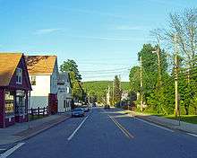
Two main thoroughfares run through Patterson, NY State Route 22 & State Route 311. State Route 22 runs through every town on the East side of Putnam County, and runs directly through the Business District of Patterson. I-84 passes in the southwest and houses Exit 18 for Route 311. Metro-North Railroad has rail commuter rail service to New York City via the Harlem Line, with the Patterson train station in the town center.
Government
Patterson is governed by a town board. The town hall is located on New York State Route 311 in Patterson. Law enforcement services for Patterson are provided by the New York State Police and the Putnam County Sheriff's Department.
Communities and locations in Patterson
- Barnum Corners – A hamlet west of Putnam Lake.
- Camp Brady – A location in the western part of the town.
- Cascade Farm and Farm School Inc. – A small Community Supported Agricultural farm on Harmony Road off Rte. 292 in Patterson.
- Fields Corners – A hamlet in the southwest part of the town.
- Haines Corners – A hamlet southwest of Haviland Hollow.
- Haviland Hollow – A hamlet northwest of Putnam Lake.
- Patterson – A hamlet in the north part of the town.
- Putnam Lake – A hamlet west of the lake named Putnam Lake, which is in the eastern part of the town by the Connecticut border.
- Steinbeck Corners – A hamlet in the southern part of the town.
- Thunder Ridge – A ski area located north of Putnam Lake.
- West Patterson – A hamlet west of Patterson hamlet.
- Haviland Hollow Farm – A polo and equestrian facility, built on historic Colonial River Farm located on East Branch Road in Patterson.
- Watchtower Educational Center, (Watchtower Bible School of Gilead) a religious school, office, and residence complex operated by Jehovah's Witnesses using the legal entity the Watch Tower Bible and Tract Society of Pennsylvania; the facility draws thousands of domestic and international visitors each year to its free guided tours and by-invitation educational programs.
- Wonder Lake State Park – An 1100+ acre state park on the western side of the town, off Interstate 84.
References
- ↑ Historic Patterson, NY; accessed 2011-02-15.
- ↑ "Patterson Through the Years". historicpatterson.org. Retrieved 6 October 2015.
- ↑ "Putnam County history". Rootsweb. 2007. Retrieved 2008-01-15.
- ↑ Taskin, Richard. "Pete SeegerAppreciation Page". Retrieved 2009-05-06.
- ↑ Obituary, Cushman, Martha Bryan Allen, The New York Times; July 30, 1985; pg. A30
- ↑ "Yahoo! Groups". yahoo.com. Retrieved 6 October 2015.
- ↑ Wonder Lake State Park
- ↑ "Annual Estimates of the Resident Population for Incorporated Places: April 1, 2010 to July 1, 2014". Retrieved June 4, 2015.
- ↑ "Census of Population and Housing". Census.gov. Retrieved June 4, 2015.
- ↑ "American FactFinder". United States Census Bureau. Retrieved 2008-01-31.
External links
| Wikimedia Commons has media related to Patterson, New York. |
- Town of Patterson, NY
- Historic Patterson: History of Patterson, NY
- History of Patterson, NY
- Patterson Fire Department
- Putnam Lake Fire Department
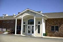
- Patterson Library
- Boy Scout Troop 440 Patterson
- Map of Patterson, NY by MapQuest
- Patterson, New York at DMOZ
Municipalities and communities of Putnam County, New York, United States | ||
|---|---|---|
| Towns | 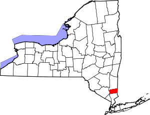 | |
| Villages | ||
| CDPs | ||
| Other hamlets | ||
| Footnotes | ‡This populated place also has portions in an adjacent county or counties | |