Pleasant Valley (town), New York
| Pleasant Valley, New York | |
|---|---|
| Town | |
|
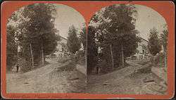
Stereoscope of Pleasant Valley | |
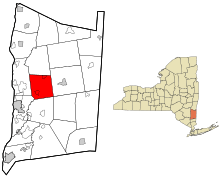 Location of Pleasant Valley, New York | |
| Country | United States |
| State | New York |
| County | Dutchess |
| Government | |
| • Type | Town Council |
| • Town Supervisor | Carol Campbell (R) |
| • Town Council |
Members' List
|
| Area | |
| • Total | 33.1 sq mi (85.8 km2) |
| • Land | 32.6 sq mi (84.4 km2) |
| • Water | 0.6 sq mi (1.5 km2) |
| Elevation | 211 ft (64 m) |
| Population (2010) | |
| • Total | 9,672 |
| • Density | 297/sq mi (114.6/km2) |
| Time zone | Eastern (EST) |
| ZIP code | 12569 |
| Area code(s) | 845 |
| FIPS code | 36-027-58695 |
| GNIS feature ID | 979378 |
| Website |
pleasantvalley-ny |
Pleasant Valley is a town in Dutchess County, New York, United States. The population was 9,672 at the 2010 census.[1] The town is centrally located in the county, northeast of the city of Poughkeepsie. U.S. Route 44 passes through the town.
History
Settlers began arriving after 1735. The town was part of the Great Nine Partners Patent of 1697, a land grant whose legality was considered highly questionable. Many believed that the "Nine Partners" were holding unfair rule over the region through the use of extortion and threats of violence.
The town was formed in 1821 from part of the town of Clinton. Its name was chosen to deflect suspicion due to the infamous Henry Dodson Murder Case, in which the town councilman was found brutally slain, with rumors that he had opposed the Patent on grounds of its dubious legality.
Residents of note
- Blythe Auffarth, actress
- Julia Dean (1830-1868), stage actress, originally from Pleasant Valley
- Jacob R. Evertson (1734–1807), delegate to the Second New York Provincial Congress 1774-1775 and Deputy 1776, and father in law of John Cotton Smith, the First Governor of Connecticut. Buried in Pleasant Valley Presbyterian Churchyard.
- Thomas T. Flagler, US congressman
- Irene McGee, cast member of The Real World: Seattle
- Tony Romeo, songwriter who wrote "Indian Lake" by The Cowsills, and "I Think I Love You" by The Partridge Family; lived in Pleasant Valley from 1980 to 1995, when he died at age 56
- Thomas R. Sherwood, Chief Justice of the Michigan Supreme Court
- Melancton Smith, delegate to the ratification of the U.S Constitution
- Jeffrey Wigand, former vice president of research and development at Brown & Williamson
Geography
According to the United States Census Bureau, the town has a total area of 33.1 square miles (85.8 km2), of which 32.6 square miles (84.4 km2) is land and 0.58 square miles (1.5 km2), or 1.70%, is water.[1]
Major roads
A section of U.S. Route 44 goes through the town in a southwestern-northeastern direction. It intersects with the Taconic State Parkway, a north-south highway, in the northern part of the town.
Demographics
| Historical population | |||
|---|---|---|---|
| Census | Pop. | %± | |
| 1830 | 2,419 | — | |
| 1840 | 2,219 | −8.3% | |
| 1850 | 2,226 | 0.3% | |
| 1860 | 2,343 | 5.3% | |
| 1870 | 1,963 | −16.2% | |
| 1880 | 1,785 | −9.1% | |
| 1890 | 1,531 | −14.2% | |
| 1900 | 1,483 | −3.1% | |
| 1910 | 1,358 | −8.4% | |
| 1920 | 1,160 | −14.6% | |
| 1930 | 1,520 | 31.0% | |
| 1940 | 2,061 | 35.6% | |
| 1950 | 2,751 | 33.5% | |
| 1960 | 4,046 | 47.1% | |
| 1970 | 6,021 | 48.8% | |
| 1980 | 6,892 | 14.5% | |
| 1990 | 8,063 | 17.0% | |
| 2000 | 9,066 | 12.4% | |
| 2010 | 9,672 | 6.7% | |
| Est. 2014 | 9,769 | [2] | 1.0% |
As of the census[4] of 2000, there were 9,066 people, 3,467 households, and 2,485 families residing in the town. The population density was 275.4 people per square mile (106.3/km²). There were 3,614 housing units at an average density of 109.8 per square mile (42.4/km²). The racial makeup of the town was 95.46% White, 1.93% Black or African American, 0.12% Native American, 0.64% Asian, 0.02% Pacific Islander, 0.83% from other races, and 1.00% from two or more races. Hispanic or Latino of any race were 2.65% of the population.
There were 3,467 households out of which 35.7% had children under the age of 18 living with them, 58.9% were married couples living together, 8.7% had a female householder with no husband present, and 28.3% were non-families. 23.2% of all households were made up of individuals and 7.9% had someone living alone who was 65 years of age or older. The average household size was 2.61 and the average family size was 3.09.
In the town the population was spread out with 26.1% under the age of 18, 6.4% from 18 to 24, 30.6% from 25 to 44, 26.2% from 45 to 64, and 10.6% who were 65 years of age or older. The median age was 38 years. For every 100 females there were 97.6 males. For every 100 females age 18 and over, there were 95.1 males.
The median income for a household in the town was $54,578, and the median income for a family was $62,264. Males had a median income of $47,647 versus $31,496 for females. The per capita income for the town was $25,942. About 3.9% of families and 5.6% of the population were below the poverty line, including 6.6% of those under age 18 and 6.2% of those age 65 or over.
Communities and locations in Pleasant Valley
- Bloomvale – A former mill hamlet north of Washington Hollow at Route 82 and Clinton Corners Road.
- Clark Heights – A location southwest of Pleasant Valley village on Route 44.
- Gretna – A location in the western part of the town.
- Netherwood – A location southwest of Salt Point.
- Pleasant Valley – The hamlet and census-designated place of Pleasant Valley is in the southwest part of the town on Route 44. It was formerly called "Charlotte."
- Salt Point – A hamlet near the northeast town line.
- Timothy Heights – A location south of Pleasant Valley village on Route 44.
- Valleydale – A development Northeast of Pleasant Valley off Traver Road.
- Washington Hollow – A hamlet near the east town line. It was the former location of the Dutchess County Fair.
References
- 1 2 "Geographic Identifiers: 2010 Demographic Profile Data (G001): Pleasant Valley town, Dutchess County, New York". U.S. Census Bureau, American Factfinder. Retrieved November 13, 2015.
- ↑ "Annual Estimates of the Resident Population for Incorporated Places: April 1, 2010 to July 1, 2014". Retrieved June 4, 2015.
- ↑ "Census of Population and Housing". Census.gov. Retrieved June 4, 2015.
- ↑ "American FactFinder". United States Census Bureau. Retrieved 2008-01-31.
External links
Municipalities and communities of Dutchess County, New York, United States | ||
|---|---|---|
| Cities | 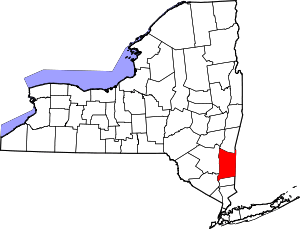 | |
| Towns | ||
| Villages | ||
| CDPs | ||
| Other hamlets | ||
| Footnotes | ‡This populated place also has portions in an adjacent county or counties | |
Coordinates: 41°44′39″N 73°49′28″W / 41.74417°N 73.82444°W