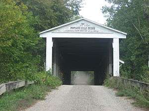
Portland Mills Covered Bridge
| Portland Mills Covered Bridge | |
| National Register of Historic Places | |
 Portland Mills Covered Bridge | |
| Official name: Portland Mills Covered Bridge | |
| Named for: Portland Mills | |
| Country | |
|---|---|
| State | |
| County | Parke |
| Township | Greene |
| Road | C.R. E650N |
| Crosses | Little Raccoon Creek |
| Coordinates | 39°51′38.67″N 87°5′19.66″W / 39.8607417°N 87.0887944°WCoordinates: 39°51′38.67″N 87°5′19.66″W / 39.8607417°N 87.0887944°W |
| Length | 146 ft (45 m) 130ft +8ft overhangs on each end |
| Width | 16 ft (5 m) [1] |
| Clearance | 13 ft (4 m) |
| Builder | Wolf, Henry |
| Design | Double Burr Arch truss single-span bridge |
| Material | Wood |
| Built | 1856 |
| - Moved | 1960-61 to present site from Greene Township |
| Owned and Maintained by | Parke County |
| NBI Number | 6100112[2] |
| WGCB Number | #14-61-21 [3] |
| Added to NRHP | Dec 22, 1978 |
| NRHP Ref# | 78000408[4] |
| MPS | Parke County Covered Bridges TR |
 Location of the Portland Mills Bridge in Indiana | |
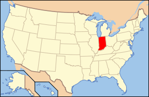 Location of Indiana in the United States | |
The Portland Mills Covered Bridge is the second oldest covered bridge in Parke County, Indiana, being built the same year as the Crooks Covered Bridge. It is a single span Burr Arch Truss covered bridge that was built by Henry Wolf in 1856.[1][3][5]
It was added to the National Register of Historic Places in 1978.[4]
History
The village of Portland Mills was settled in 1821 by Samuel Steele on the Parke County-Putnam County county line. Working to clear the land for farming he later built a mill in 1825 on Big Raccoon Creek. The grain mill had a water turbine, as apposed to a water wheel, and a sawmill. The mill would go through several owners, William Butcher, Jesse Thompson, and Wesley Holman. Holman would build a new three story mill on a solid sandstone foundation and obtained modern machinery. This mill would go through several owners also. The list includes, Hirem Hocker, John Blake, Jacob Culver, James Williams, and a Mr. Williams.
While the Parke County Covered Bridge website claims the bridge started out in Union Township after looking at plat maps from 1874[6] it would appear that the bridge may have been in the southeast corner of Greene Township. While a clear location is lost because of the flooding of Big Raccoon Creek in 1961, it looks as if the bridge would have been very close to 39°46′44.22″N 87°0′54.43″W / 39.7789500°N 87.0151194°W.
Because of the afore mentioned flooding of Big Raccoon Creek to build what was then called Mansfield lake, today's Cecil M. Harden Lake, in January 1961 the bridge was moved to its current location to replace the Dooley Station Covered Bridge which was the victim of arson in 1960.
The bridge was allowed to deteriorate and fall into disrepair. Because sections of the roof and siding were later missing damaging rain was allowed in and the northeast corner had even been damaged by fire. The bridge was eventually closed in 1982 and bypassed by a ford. By the 1990s the bridge had fallen into severe neglect that it was in grave danger of collapse. However, funds from a grant and help from local organizations and donations allowed it to be restored to its original state in 1996. The bridge has even been reopened to traffic.
Gallery

 Collapsed portal prior to the 1996 renovation
 Extensive missing siding prior to the 1996 renovation
See also
- List of Registered Historic Places in Indiana
- Parke County Covered Bridges
- Parke County Covered Bridge Festival
References
- 1 2 "Portland Mills Covered Bridge (#4)". coveredbridges.com. Parke County Incorporated / Parke County Convention and Visitors Commission. Retrieved 2012-10-18.
- ↑ http://Nationalbridges.com
- 1 2 http://www.indianacrossings.org/bridgeLinks/14-61-21.html
- 1 2 National Park Service (2007-01-23). "National Register Information System". National Register of Historic Places. National Park Service.
- ↑ "Indiana State Historic Architectural and Archaeological Research Database (SHAARD)" (Searchable database). Department of Natural Resources, Division of Historic Preservation and Archaeology. Retrieved 2016-06-01. Note: This includes Charles Felkner (December 1977). "National Register of Historic Places Inventory Nomination Form: Parke County Covered Bridge Historic District" (PDF). Retrieved 2016-06-01., Site map, and Accompanying photographs.
- ↑ http://www.indianagenweb.com/inparke/Maps/1874AtlasPage90HowardWestportSylvaniaPortlandMills.jpg

