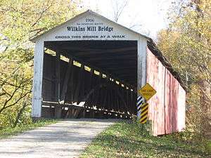
Wilkins Mill Covered Bridge
| Wilkins Mill Covered Bridge | |
| National Register of Historic Places | |
 Wilkins Mill Covered Bridge | |
| Official name: Wilkins Mill Covered Bridge | |
| Named for: Wilkins Mill | |
| Country | |
|---|---|
| State | |
| County | Parke |
| Township | Sugar Creek |
| Road | Cox Ford Road |
| Crosses | Sugar Mill Creek |
| Coordinates | 39°53′54.09″N 87°13′59.37″W / 39.8983583°N 87.2331583°WCoordinates: 39°53′54.09″N 87°13′59.37″W / 39.8983583°N 87.2331583°W |
| Length | 120 ft (37 m) 102ft +9ft overhangs on each end |
| Width | 16 ft (5 m) [1] |
| Clearance | 13 ft (4 m) |
| Builder | Hendricks, William |
| Design | Burr Arch truss single-span bridge |
| Material | Wood |
| Built | 1906 |
| - Repaired | 1991 $6,000 |
| Owned and Maintained by | Parke County |
| NBI Number | 6100172[2] |
| WGCB Number | #14-61-35 [3] |
| Added to NRHP | Dec 22, 1978 |
| NRHP Ref# | 78000415 [4] |
| MPS | Parke County Covered Bridges TR |
 Location of the Wilkins Mill Bridge in Indiana | |
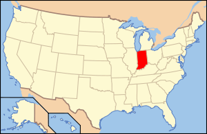 Location of Indiana in the United States | |
The Wilkins Mill Covered Bridge is north of Rockville, Indiana. The single span Burr Arch Truss covered bridge structure was built by William Hendricks in 1906. The bridge is 120 feet (37 m) long, 16 feet (4.9 m) wide, and 13 feet (4.0 m) high.[5][6]
It was added to the National Register of Historic Places in 1978.[4]
History
Solomon Jessup and Zimri Hunt built a mill in 1835 upstream from the bridge site. George Wilkins later opened a store there in 1853 and a carding mill, operated by Solomon Jessup and William Hunt was also built. In 1855 Wilkins bought the mill but later tore it down and built a new one. This is the source of the name Wilkins Mill, however, in 1877 this mill burned down and another mill was built which stood until 1947.[5]
The 1874 Atlas of Parke County shows that the creek was named Mill Creek,[7] but today it is labeled as Sugar Mill Creek. Sugar Mill Creek and Green Creek converge below the bridge and it would seem that after one flood the Sugar Mill Creek changed its course and left the bridge standing over a dry creek bed for a period of time. Looking at satellite picture now show that it appears the bridge is once again crossing water.
This was to be the second of three covered bridges built by William Hendricks.
Gallery

See also
- List of Registered Historic Places in Indiana
- Parke County Covered Bridges
- Parke County Covered Bridge Festival
References
- ↑ "Wilkins Mill Covered Bridge (#35)". Parke County Convention & Visitors Commission. Retrieved 16 January 2015.
- ↑ http://nationalbridges.com/
- ↑ http://www.indianacrossings.org/bridgeLinks/14-61-35.html
- 1 2 National Park Service (2007-01-23). "National Register Information System". National Register of Historic Places. National Park Service.
- 1 2 "Wilkins Mill Covered Bridge". Parke County Incorporated / Parke County Convention and Visitors Commission. Retrieved 2012-10-18.
- ↑ "Indiana State Historic Architectural and Archaeological Research Database (SHAARD)" (Searchable database). Department of Natural Resources, Division of Historic Preservation and Archaeology. Retrieved 2016-06-01. Note: This includes Charles Felkner (December 1977). "National Register of Historic Places Inventory Nomination Form: Parke County Covered Bridge Historic District" (PDF). Retrieved 2016-06-01., Site map, and Accompanying photographs.
- ↑ http://www.indianagenweb.com/inparke/Maps/1874AtlasPage031SugarCreekTownshipMap.jpg

