Sanitorium Covered Bridge
| State Sanitorium Covered Bridge | |
| National Register of Historic Places | |
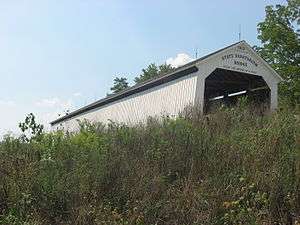 Southern Side and Eastern Portal | |
| Official name: State Sanitorium Covered Bridge | |
| Named for: The State Sanitorium | |
| Country | |
|---|---|
| State | |
| County | Parke |
| Township | Adams |
| Road | C.R. 100N |
| Crosses | Little Raccoon Creek |
| Coordinates | 39°46′52″N 87°8′42″W / 39.78111°N 87.14500°WCoordinates: 39°46′52″N 87°8′42″W / 39.78111°N 87.14500°W |
| Length | 170 ft (52 m) 154ft +8ft overhangs on each end |
| Width | 16 ft (5 m) [1] |
| Clearance | 12.5 ft (4 m) |
| Builder | Britton, J.A. |
| Design | Burr Arch truss single span bridge |
| Material | Wood |
| Built | 1913 |
| - Rebuilt and Moved | 2008 |
| Owned and Maintained by | Parke County |
| NBI Number | 6100240[2] |
| WGCB Number | #14-61-38 [3] |
| Added to NRHP | Dec 22, 1978 |
| NRHP Ref# | 78000412[4] |
| MPS | Parke County Covered Bridges TR |
 Location of the State Sanitorium Bridge in Indiana | |
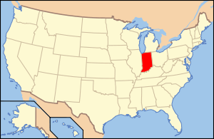 Location of Indiana in the United States | |
The Sanitorium Covered Bridge is east of Rockville, Indiana. The single-span Burr Arch covered bridge structure was built by Joseph A. Britton in 1913.[5][6]
It was added to the National Register of Historic Places in 1978.[4]
History
On March 8, 1907 the 65th Indiana General Assembly approved funding to establish and fund a State Tuberculosis Hospital or Sanitorium. By 1908 the State had appropriated land east of Rockville for the use of the State Tuberculosis Hospital.[7] The Sanitorium was soon up and running in 1910.
Originally built on the property of the State Sanitorium, located a mile or so downstream (39°45′57.6″N 87°9′40.7″W / 39.766000°N 87.161306°W) from its current site, for hauling coal to the Sanitorium. The Sanitorium used coal, mined only a couple of miles away near Nyesville,[8] for both heat and for its powerplant. This coal would have been hauled to Rockville and then east across the Plank Road Bridge to the Sanitorium before the bridge being built. The Plank Road Bridge was washed out in the flood of 1913 and was replaced with the Howard Bridge, also built by Britton the same year.
Being on private property after the State sold the Sanitorium the bridge fell into disrepair. On July 30, 2008 the $1.34 million project to move the bridge to the former site of the Adams Covered Bridge was started. The Adams Bridge had been located about a mile upstream and had been built in 1907 by J.P. Van Fossen. In 1969 the bridge was destroyed by a flood where it washed downstream and under the Sanitorium Bridge. During February 3–11, 1970, the Jessup Covered Bridge was moved to replace it. Again in 1989 flood waters would wash this bridge downstream and under the Sanitorium Bridge and over the U.S. 36 bridge. By December 29, 2008 the bridge was open to traffic even though some tasks, such as painting, had to wait until the following spring.
See also
- List of Registered Historic Places in Indiana
- Parke County Covered Bridges
- Parke County Covered Bridge Festival
References
- ↑ "State Sanatorium Covered Bridge (#1)". coveredbridges.com. Parke County Convention & Visitors Commission. Retrieved 2015-09-05.
- ↑ "National Bridge Inventory Database Search - 2012". nationalbridges.com. Retrieved 2015-09-05.
- ↑ "Bridge Information". indianacrossings.org. Retrieved 2015-09-05.
- 1 2 National Park Service (2010-07-09). "National Register Information System". National Register of Historic Places. National Park Service.
- ↑ "State Sanatorium Covered Bridge". Parke County Incorporated / Parke County Convention and Visitors Commission. Retrieved 2012-10-18.
- ↑ "Indiana State Historic Architectural and Archaeological Research Database (SHAARD)" (Searchable database). Department of Natural Resources, Division of Historic Preservation and Archaeology. Retrieved 2016-06-01. Note: This includes Charles Felkner (December 1977). "National Register of Historic Places Inventory Nomination Form: Parke County Covered Bridge Historic District" (PDF). Retrieved 2016-06-01., Site map, and Accompanying photographs.
- ↑ "Image: 1905ParkeCountyAtlasAdamsTownship.jpg, (1895 × 1610 px)". indianagenweb.com. 2006-08-23. Retrieved 2015-09-05.
- ↑ "Image: 1874AtlasPage034WashingtonTownship.jpg, (1853 × 2343 px)". indianagenweb.com. 2007-02-21. Retrieved 2015-09-05.

