Princeton, Kansas
| Princeton, Kansas | |
|---|---|
| City | |
 Location within Franklin County and Kansas | |
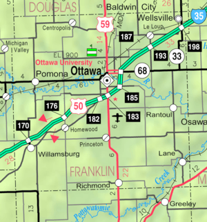 KDOT map of Franklin County (legend) | |
| Coordinates: 38°29′18″N 95°16′13″W / 38.48833°N 95.27028°WCoordinates: 38°29′18″N 95°16′13″W / 38.48833°N 95.27028°W | |
| Country | United States |
| State | Kansas |
| County | Franklin |
| Area[1] | |
| • Total | 0.33 sq mi (0.85 km2) |
| • Land | 0.33 sq mi (0.85 km2) |
| • Water | 0 sq mi (0 km2) |
| Elevation | 968 ft (295 m) |
| Population (2010)[2] | |
| • Total | 277 |
| • Estimate (2012[3]) | 276 |
| • Density | 840/sq mi (330/km2) |
| Time zone | Central (CST) (UTC-6) |
| • Summer (DST) | CDT (UTC-5) |
| ZIP code | 66078 |
| Area code(s) | 785 |
| FIPS code | 20-57725 [4] |
| GNIS feature ID | 0477586 [5] |
Princeton is a city in Franklin County, Kansas, United States. As of the 2010 census, the city population was 277.[6]
History
Princeton had its start about 1869 by the building of the railroad through that territory.[7] It was named after the city of Princeton, Illinois.[8]
The railroad no longer runs through Princeton, and the former tracks have been converted into the Prairie Spirit rail trail.[9]
Geography
Princeton is located at 38°29′18″N 95°16′13″W / 38.48833°N 95.27028°W (38.488387, -95.270357).[10] According to the United States Census Bureau, the city has a total area of 0.33 square miles (0.85 km2), all of it land.[1]
Demographics
| Historical population | |||
|---|---|---|---|
| Census | Pop. | %± | |
| 1880 | 103 | — | |
| 1930 | 210 | — | |
| 1940 | 187 | −11.0% | |
| 1950 | 177 | −5.3% | |
| 1960 | 174 | −1.7% | |
| 1970 | 159 | −8.6% | |
| 1980 | 244 | 53.5% | |
| 1990 | 275 | 12.7% | |
| 2000 | 317 | 15.3% | |
| 2010 | 277 | −12.6% | |
| Est. 2015 | 265 | [11] | −4.3% |
| U.S. Decennial Census | |||
2010 census
As of the census[2] of 2010, there were 277 people, 109 households, and 78 families residing in the city. The population density was 839.4 inhabitants per square mile (324.1/km2). There were 121 housing units at an average density of 366.7 per square mile (141.6/km2). The racial makeup of the city was 95.3% White, 1.1% Native American, and 3.6% from two or more races. Hispanic or Latino of any race were 4.3% of the population.
There were 109 households of which 37.6% had children under the age of 18 living with them, 53.2% were married couples living together, 14.7% had a female householder with no husband present, 3.7% had a male householder with no wife present, and 28.4% were non-families. 22.0% of all households were made up of individuals and 6.4% had someone living alone who was 65 years of age or older. The average household size was 2.54 and the average family size was 2.97.
The median age in the city was 33.5 years. 27.4% of residents were under the age of 18; 9.1% were between the ages of 18 and 24; 25.6% were from 25 to 44; 26.7% were from 45 to 64; and 11.2% were 65 years of age or older. The gender makeup of the city was 45.8% male and 54.2% female.
2000 census
As of the census[4] of 2000, there are 317 people, 111 households, and 88 families residing in the city. The population density is 941.9 people per square mile (360.0/km²). There are 118 housing units at an average density of 350.6 per square mile (134.0/km²). The racial makeup of the city is 95.90% White, 0.63% African American, 0.63% Asian, and 2.84% from two or more races. 0.63% of the population are Hispanic or Latino of any race.
There are 111 households out of which 45.0% have children under the age of 18 living with them, 65.8% are married couples living together, 9.9% have a female householder with no husband present, and 20.7% are non-families. 18.9% of all households are made up of individuals and 9.0% have someone living alone who is 65 years of age or older. The average household size is 2.86 and the average family size is 3.19.
In the city the population is spread out with 33.4% under the age of 18, 9.5% from 18 to 24, 29.3% from 25 to 44, 18.3% from 45 to 64, and 9.5% who are 65 years of age or older. The median age is 32 years. For every 100 females there are 109.9 males. For every 100 females age 18 and over, there are 95.4 males.
The median income for a household in the city is $33,333, and the median income for a family is $36,042. Males have a median income of $26,607 versus $20,139 for females. The per capita income for the city is $11,698. 8.5% of the population and 4.9% of families are below the poverty line. Out of the total population, 5.2% of those under the age of 18 and 23.1% of those 65 and older are living below the poverty line.
References
- 1 2 "US Gazetteer files 2010". United States Census Bureau. Retrieved 2012-07-06.
- 1 2 "American FactFinder". United States Census Bureau. Retrieved 2012-07-06.
- ↑ "Population Estimates". United States Census Bureau. Retrieved 2013-05-29.
- 1 2 "American FactFinder". United States Census Bureau. Retrieved 2008-01-31.
- ↑ "US Board on Geographic Names". United States Geological Survey. 2007-10-25. Retrieved 2008-01-31.
- ↑ "2010 City Population and Housing Occupancy Status". U.S. Census Bureau. Retrieved April 4, 2012.
- ↑ Blackmar, Frank Wilson (1912). Kansas: A Cyclopedia of State History, Volume 2. Standard Publishing Company. p. 505.
- ↑ "Profile for Princeton, Kansas". ePodunk. Retrieved 10 June 2014.
- ↑ "Trail of the Month: August 2011; Kansas' Prairie Spirit Trail". Rails-to-Trails Conservancy. Retrieved 9 May 2014.
- ↑ "US Gazetteer files: 2010, 2000, and 1990". United States Census Bureau. 2011-02-12. Retrieved 2011-04-23.
- ↑ "Annual Estimates of the Resident Population for Incorporated Places: April 1, 2010 to July 1, 2015". Retrieved July 2, 2016.
External links
| Wikimedia Commons has media related to Princeton, Kansas. |
- City
- Schools
- USD 288, local school district
- Maps
- Princeton City Map, KDOT
Municipalities and communities of Franklin County, Kansas, United States | ||
|---|---|---|
| Cities | 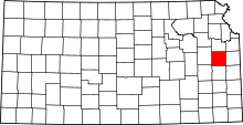 | |
| Unincorporated communities | ||
| Ghost towns | ||
| Townships | ||