Williamsburg, Kansas
| Williamsburg, Kansas | |
|---|---|
| City | |
|
Williamsburg Museum (2008) | |
 Location within Franklin County and Kansas | |
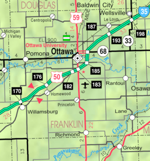 KDOT map of Franklin County (legend) | |
| Coordinates: 38°28′48″N 95°27′58″W / 38.48000°N 95.46611°WCoordinates: 38°28′48″N 95°27′58″W / 38.48000°N 95.46611°W | |
| Country | United States |
| State | Kansas |
| County | Franklin |
| Area[1] | |
| • Total | 0.66 sq mi (1.71 km2) |
| • Land | 0.65 sq mi (1.68 km2) |
| • Water | 0.01 sq mi (0.03 km2) |
| Elevation | 1,142 ft (348 m) |
| Population (2010)[2] | |
| • Total | 397 |
| • Estimate (2012[3]) | 395 |
| • Density | 600/sq mi (230/km2) |
| Time zone | Central (CST) (UTC-6) |
| • Summer (DST) | CDT (UTC-5) |
| ZIP code | 66095 |
| Area code(s) | 785 |
| FIPS code | 20-79300 [4] |
| GNIS feature ID | 0477577 [5] |
| Website | WilliamsburgKS.us |

Williamsburg is a city in Franklin County, Kansas, United States. As of the 2010 census, the city population was 397.[6]
History
Williamsburg was founded in 1868.[7] It was named for its founder, William Schofield.[8]
The first post office in Williamsburg was established in April, 1869, and it was officially spelled Williamsburgh until 1894.[9]
Geography
Williamsburg is located at 38°28′48″N 95°27′58″W / 38.48000°N 95.46611°W (38.480115, -95.466016).[10] According to the United States Census Bureau, the city has a total area of 0.66 square miles (1.71 km2), of which 0.65 square miles (1.68 km2) is land and 0.01 square miles (0.03 km2) is water.[1]
Climate
The climate in this area is characterized by hot, humid summers and generally mild to cool winters. According to the Köppen Climate Classification system, Williamsburg has a humid subtropical climate, abbreviated "Cfa" on climate maps.[11]
Demographics
| Historical population | |||
|---|---|---|---|
| Census | Pop. | %± | |
| 1880 | 419 | — | |
| 1890 | 502 | 19.8% | |
| 1910 | 399 | — | |
| 1920 | 404 | 1.3% | |
| 1930 | 367 | −9.2% | |
| 1940 | 365 | −0.5% | |
| 1950 | 297 | −18.6% | |
| 1960 | 255 | −14.1% | |
| 1970 | 286 | 12.2% | |
| 1980 | 362 | 26.6% | |
| 1990 | 261 | −27.9% | |
| 2000 | 351 | 34.5% | |
| 2010 | 397 | 13.1% | |
| Est. 2015 | 384 | [12] | −3.3% |
| U.S. Decennial Census | |||
2010 census
As of the census[2] of 2010, there were 397 people, 149 households, and 101 families residing in the city. The population density was 610.8 inhabitants per square mile (235.8/km2). There were 159 housing units at an average density of 244.6 per square mile (94.4/km2). The racial makeup of the city was 96.2% White, 0.3% African American, 1.5% Native American, and 2.0% from two or more races. Hispanic or Latino of any race were 3.0% of the population.
There were 149 households of which 34.2% had children under the age of 18 living with them, 52.3% were married couples living together, 8.1% had a female householder with no husband present, 7.4% had a male householder with no wife present, and 32.2% were non-families. 27.5% of all households were made up of individuals and 12.7% had someone living alone who was 65 years of age or older. The average household size was 2.66 and the average family size was 3.26.
The median age in the city was 36.6 years. 27.7% of residents were under the age of 18; 9.8% were between the ages of 18 and 24; 26% were from 25 to 44; 21.7% were from 45 to 64; and 14.9% were 65 years of age or older. The gender makeup of the city was 52.4% male and 47.6% female.
2000 census
As of the census[4] of 2000, there were 351 people, 139 households, and 98 families residing in the city. The population density was 1,036.0 people per square mile (398.6/km²). There were 161 housing units at an average density of 475.2 per square mile (182.8/km²). The racial makeup of the city was 97.15% White, 1.71% Native American, and 1.14% from two or more races. Hispanic or Latino of any race were 0.57% of the population.
There were 139 households out of which 33.1% had children under the age of 18 living with them, 48.9% were married couples living together, 14.4% had a female householder with no husband present, and 28.8% were non-families. 28.1% of all households were made up of individuals and 13.7% had someone living alone who was 65 years of age or older. The average household size was 2.53 and the average family size was 3.02.
In the city the population was spread out with 31.3% under the age of 18, 8.0% from 18 to 24, 26.5% from 25 to 44, 19.4% from 45 to 64, and 14.8% who were 65 years of age or older. The median age was 32 years. For every 100 females there were 87.7 males. For every 100 females age 18 and over, there were 82.6 males.
The median income for a household in the city was $23,393, and the median income for a family was $25,000. Males had a median income of $21,354 versus $21,364 for females. The per capita income for the city was $10,451. About 18.2% of families and 17.4% of the population were below the poverty line, including 27.4% of those under age 18 and 7.7% of those age 65 or over.
References
- 1 2 "US Gazetteer files 2010". United States Census Bureau. Retrieved 2012-07-06.
- 1 2 "American FactFinder". United States Census Bureau. Retrieved 2012-07-06.
- ↑ "Population Estimates". United States Census Bureau. Retrieved 2013-05-29.
- 1 2 "American FactFinder". United States Census Bureau. Retrieved 2008-01-31.
- ↑ "US Board on Geographic Names". United States Geological Survey. 2007-10-25. Retrieved 2008-01-31.
- ↑ "2010 City Population and Housing Occupancy Status". U.S. Census Bureau. Retrieved March 6, 2011.
- ↑ Kansas State Historical Society (1916). Biennial Report of the Board of Directors of the Kansas State Historical Society. Kansas State Printing Plant. p. 192.
- ↑ Heim, Michael (2007). Exploring Kansas Highways. p. 8.
- ↑ "Kansas Post Offices, 1828-1961 (archived)". Kansas Historical Society. Archived from the original on October 9, 2013. Retrieved 10 June 2014.
- ↑ "US Gazetteer files: 2010, 2000, and 1990". United States Census Bureau. 2011-02-12. Retrieved 2011-04-23.
- ↑ Climate Summary for Williamsburg, Kansas
- ↑ "Annual Estimates of the Resident Population for Incorporated Places: April 1, 2010 to July 1, 2015". Retrieved July 2, 2016.
External links
- City
| Wikimedia Commons has media related to Williamsburg, Kansas. |
- Schools
- USD 287, local school district
- Maps
- Williamsburg City Map, KDOT
Municipalities and communities of Franklin County, Kansas, United States | ||
|---|---|---|
| Cities | 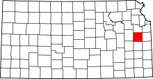 | |
| Unincorporated communities | ||
| Ghost towns | ||
| Townships | ||