Rice, California
| Rice, California | |
|---|---|
| Ghost town | |
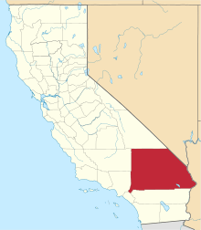
 Rice, California Location within the state of California | |
| Coordinates: 34°5′1″N 114°50′59″W / 34.08361°N 114.84972°WCoordinates: 34°5′1″N 114°50′59″W / 34.08361°N 114.84972°W | |
| Country | United States |
| State | California |
| County | San Bernardino |
| Elevation | 832 ft (254 m) |
| Population (2000) | |
| • Total | 0 |
| Time zone | Pacific (PST) (UTC-8) |
| • Summer (DST) | PDT (UTC-7) |
| GNIS feature ID | 248157[1] |
Rice, California, formerly named Blythe Junction, is a vacant town site in the Rice Valley and the southern tip of the Mojave Desert, and within unincorporated San Bernardino County, southern California.
History
The town, located on present-day California State Route 62 between Twentynine Palms and the Colorado River, grew around a Santa Fe Railroad subdivision[2] and siding. The subdivision and siding are still in use, but have since changed hands and currently belong to the Arizona and California Railroad, a short line serving southeastern California from Rice to Cadiz, California and southwestern Arizona at Parker. It was the starting point of the abandoned Ripley Branch that goes through Blythe to Ripley, California.
Rice Army Airfield/Rice Airport
To the east of Rice is the Rice Municipal Airport, which was acquired by the United States Army's 4th Air Support Command in 1942 as a sub-base of Thermal Army Airfield,[3] and was operational by the end of the year. While the airfield's date of construction is unknown, it was not depicted on a 1932 Los Angeles Airways Chart, indicating construction sometime in the ten years between 1932 and 1942. Rice Army Airfield consisted of two intersecting paved 5,000 foot runways and numerous dispersal pads south of the runways. In 1944 the airfield was transferred from Thermal Army Airfield to March Field. Operations at Rice Field were ended by August 1944, and the field was declared surplus on 31 October 1944.[4]
The desert training area near Rice Army Airfield was at one time considered as the site for the world's first atomic-bomb test ("Trinity"), and in fact was the second-choice site. Instead, a site near Alamogordo, New Mexico, was chosen.[5]
Rice Shoe Tree
Rice became noted for its Rice Shoe Tree, a lone tamarisk on a turnout just south of the highway. For reasons unknown, it became customary for travelers on Highway 62 (also known as Rice Road) to and from the Colorado River to hang an old shoe on the tree's branches. The tree was featured on California's Gold, a PBS program hosted by Huell Howser. The tree burned to the ground in 2003 in a fire of suspicious origin, after which a 'shoe garden' replaced it; a fence on which people hang shoes instead. Travelers still stop to spell their names on the nearby Arizona and California Railroad right-of-way with the multi-colored volcanic rock used as ballast. Hand-assembled graffiti lines the railroad for the entire distance that it parallels Highway 62.
Present day

At some point during the period 1944–48, Rice Army Airfield was renamed Rice Airport and began operations as a public civilian airport, housing a small flight school for missionaries. Between 1952 and 1955, Rice Airport was changed to a private field, and by 1960 it had been abandoned. As of 2007, no standing structures remain and little evidence exists of the airport's former existence.[4]
There are no standing buildings and no residents in Rice at present. A hand-painted sign on the western outskirts of the town once announced that the townsite was for sale, but that sign has since been removed. The only building which remains in any condition is a demolished service station.
In 2010, there was filming for the 2011 movie Fast Five near Rice.[6] It was featured during the train scene in the beginning of the movie.
References
- ↑ "Rice, California". Geographic Names Information System. United States Geological Survey.
- ↑ Defined as "A portion of a division designated by timetable." http://www.transportation-dictionary.org/Railroad-Dictionary/Subdivision Railroad Dictionary; accessed 31 July 2012
- ↑ "Thermal Army Air Field / Naval Air Facility, Thermal". militarymuseum.org. Retrieved 9 November 2015.
- 1 2 Abandoned & Little-Known Airfields: California: Southeastern San Bernardino County
- ↑ "Auto trips were made to the regions north and south of Grants and Thoreau, the Tularosa basin, the Jornada del Muerto Valley, and the desert training area. Aerial surveys were made at low altitude by one or another of the group, K. Bainbridge, R. W. Henderson, Maj. W. A. Stevens, and Maj. P. deSilva, over the same areas. The choices finally narrowed to either the Jornada del Muerto region in the northwest corner of the Alamogordo Bombing Range or the desert training area north of Rice, CA." Kenneth T. Bainbridge, "Trinity" (LA-6300-H), May 1976 (reprinting a 1947 report).
- ↑ Travis, Joan M. (2011-04-13). "Film crew gives Parker area economic boost". Parker Pioneer. Retrieved 2016-04-21.
External links
- History of Midland, Calif (nearby ghost town)