Saint-Vérand, Isère
| Saint-Vérand | |
|---|---|
|
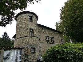
Chateau of Quincivet | |
 Saint-Vérand | |
|
Location within Auvergne-Rhône-Alpes region  Saint-Vérand | |
| Coordinates: 45°10′26″N 5°19′57″E / 45.1739°N 5.3325°ECoordinates: 45°10′26″N 5°19′57″E / 45.1739°N 5.3325°E | |
| Country | France |
| Region | Auvergne-Rhône-Alpes |
| Department | Isère |
| Arrondissement | Grenoble |
| Canton | Saint-Marcellin |
| Intercommunality | Pays de Saint-Marcellin |
| Government | |
| • Mayor (2014–2020) | Bernard Eyssard |
| Area1 | 17.83 km2 (6.88 sq mi) |
| Population (2011)2 | 1,796 |
| • Density | 100/km2 (260/sq mi) |
| Time zone | CET (UTC+1) |
| • Summer (DST) | CEST (UTC+2) |
| INSEE/Postal code | 38463 / 38160 |
| Elevation |
276–480 m (906–1,575 ft) (avg. 290 m or 950 ft) |
|
1 French Land Register data, which excludes lakes, ponds, glaciers > 1 km² (0.386 sq mi or 247 acres) and river estuaries. 2 Population without double counting: residents of multiple communes (e.g., students and military personnel) only counted once. | |
Saint-Vérand is a commune in the Isère department in southeastern France.
Population
| Historical population | ||
|---|---|---|
| Year | Pop. | ±% |
| 1793 | 836 | — |
| 1806 | 945 | +13.0% |
| 1821 | 902 | −4.6% |
| 1831 | 1,041 | +15.4% |
| 1841 | 1,110 | +6.6% |
| 1851 | 1,183 | +6.6% |
| 1861 | 1,062 | −10.2% |
| 1872 | 1,064 | +0.2% |
| 1881 | 992 | −6.8% |
| 1891 | 955 | −3.7% |
| 1901 | 933 | −2.3% |
| 1911 | 874 | −6.3% |
| 1921 | 803 | −8.1% |
| 1931 | 348 | −56.7% |
| 1946 | 860 | +147.1% |
| 1954 | 848 | −1.4% |
| 1962 | 886 | +4.5% |
| 1968 | 839 | −5.3% |
| 1975 | 1,044 | +24.4% |
| 1982 | 1,251 | +19.8% |
| 1990 | 1,348 | +7.8% |
| 1999 | 1,441 | +6.9% |
| 2001 | 1,730 | +20.1% |
| 2011 | 1,796 | +3.8% |
See also
References
| Wikimedia Commons has media related to Saint-Vérand (Isère). |
This article is issued from Wikipedia - version of the 10/28/2016. The text is available under the Creative Commons Attribution/Share Alike but additional terms may apply for the media files.