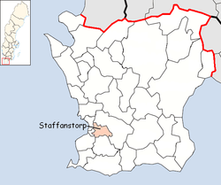
Staffanstorp Municipality
| Staffanstorp Municipality Staffanstorps kommun | ||
|---|---|---|
| Municipality | ||
| ||
 | ||
| Country | Sweden | |
| County | Skåne County | |
| Seat | Staffanstorp | |
| Area[1] | ||
| • Total | 107.28 km2 (41.42 sq mi) | |
| • Land | 106.82 km2 (41.24 sq mi) | |
| • Water | 0.46 km2 (0.18 sq mi) | |
| Area as of January 1, 2014. | ||
| Population (June 30, 2016)[2] | ||
| • Total | 23,273 | |
| • Density | 220/km2 (560/sq mi) | |
| Time zone | CET (UTC+1) | |
| • Summer (DST) | CEST (UTC+2) | |
| ISO 3166 code | SE | |
| Province | Scania | |
| Municipal code | 1230 | |
| Website | www.staffanstorp.se | |
Staffanstorp Municipality (Staffanstorps kommun) is a municipality in Skåne County, southern Sweden. Its seat is located in the town Staffanstorp.
The municipality was formed by the local government reform of 1952, when 12 original units, created out of parishes in 1863, were amalgamated. The next reform in 1971 did not affect the size of this municipality.
In the municipality there are two localities which have grown into suburbs of Malmö, Staffanstorp with 14,800 inhabitants and Hjärup with 4,000 inhabitants, which both are typical residential districts dominated by detached houses built in the second half of the 20th century, wherefrom most people commute for work in the nearby cities of Lund and Malmö.
Localities
There are 5 urban areas (also called a Tätort or locality) in Staffanstorp Municipality.
In the table they are listed according to the size of the population as of December 31, 2010. The municipal seat is in bold characters.
| # | Locality | Population |
|---|---|---|
| 1 | Staffanstorp | 14,808 |
| 2 | Hjärup | 4,265 |
| 3 | Kyrkheddinge | 276 |
| 4 | Grevie och Beden | 241 |
| 5 | Bergströmshusen | 209 |
International relations
Twin towns – Sister cities
Staffanstorp is twinned with:[3]
 Viitasaari, Central Finland
 Muntinlupa, Philippines
 Wolin, Poland
References
- ↑ "Statistiska centralbyrån, Kommunarealer den 1 januari 2014" (Microsoft Excel) (in Swedish). Statistics Sweden. Retrieved 2014-04-18.
- ↑ "Folkmängd i riket, län och kommuner 30 juni 2016" (in Swedish). Statistics Sweden. August 17, 2016. Retrieved August 17, 2016.
- ↑ "Ystävyyskunnat" (in Norwegian). City of Viitasaari. Retrieved 2012-06-01.
External links
- Staffanstorp - Official site
- Coat of arms
Municipalities and seats of Skåne County | ||
|---|---|---|
| Municipalities | ||
| Municipal seats | ||
| Localities | ||
|---|---|---|
Coordinates: 55°38′N 13°12′E / 55.633°N 13.200°E